Sarandë
Sarandë (Albanian pronunciation: [saˈɾa:ndə]; Greek: Άγιοι Σαράντα, romanized: Agioi Saranda; Italian: Santiquaranta), also Saranda, is a coastal town in Albania. Geographically, it is situated on an open sea gulf of the Ionian Sea in the central Mediterranean, about 14 km (8.7 mi) east of the northern end of the island of Corfu. Stretching along the Albanian Ionian Sea Coast, Saranda typically has over 300 sunny days a year.
Sarandë Άγιοι Σαράντα Αgioi Saranda Santiquaranta | |
|---|---|
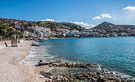 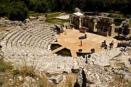   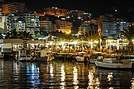    From top: The promenade of Saranda, ancient city of Butrint, castle of Lëkurësi, streets of Saranda, the city at night, coastline of Saranda, harbour of Saranda and a panoramic view from the Lëkurësi Castle towards Saranda. | |
 Emblem | |
 Sarandë | |
| Coordinates: 39°52.5′N 20°0.6′E | |
| Country | |
| County | Vlorë |
| Government | |
| • Mayor | Adrian Gurma (PS) |
| Area | |
| • Municipality | 70.13 km2 (27.08 sq mi) |
| Elevation | 0.8 m (2.6 ft) |
| Population (2020) | |
| • Municipality | 40,227 |
| • Municipality density | 570/km2 (1,500/sq mi) |
| • Municipal unit | 27,233 |
| Demonym(s) | Sarandiot (m) Sarandiote (f) |
| Time zone | UTC+1 (CET) |
| • Summer (DST) | UTC+2 (CEST) |
| Postal Code | 9701–9703 |
| Area Code | (0)85 |
| Vehicle registration | AL |
| Website | Saranda Web |
The city is known for its blue deep waters of the Mediterranean. Near Sarandë are the remains of the ancient city of Butrint, a UNESCO World Heritage site. In recent years, Saranda has seen a steady increase in tourists, many of them coming by cruise ship. Visitors are attracted by the natural environment of Saranda and its archaeological sites. Sarandë has a large Greek population and is considered one of the two centers of the Greek minority in Albania.[1]
Etymology
Saranda is from the name of the Byzantine monastery of the Agioi Saranda (Greek: Άγιοι Σαράντα), meaning the "Forty Saints", in honor of the Forty Martyrs of Sebaste. Under Ottoman rule, the town in the Turkish language became known as Aya Sarandi and then Sarandoz. Owing to Venetian influence in the region, it often appeared under its Italian name Santi Quaranta on Western maps.[2] This usage continued even after the establishment of the Principality of Albania, owing to the first Italian occupation of the region. During the Italian occupation of Albania in World War II, Benito Mussolini changed the name to Porto Edda, in honor of his eldest daughter.[3][4] Following the restoration of Albanian independence, the city employed its Albanian name Saranda.[5]
History
Ancient
Due to the archaic features found in the ancient Greek name of the city: Onchesmus (Ancient Greek: Ὄγχεσμος) and the toponyms of the surrounding region it appears that the site was part of the proto-Greek area of late 3rd-early 2nd millennium BC [6][7] Bronze Age tools typical of Mycenaean Greece have been unearthed in Sarandë which date c. 1400-1100 BC.[8] In antiquity the city was known by the name of Onchesmus or Onchesmos and was a port-town of Chaonia in ancient Epirus, opposite the northwestern point of Corcyra, and the next port upon the coast to the south of Panormus.[9][10] It was inhabited by the Greek tribe of the Chaonians.[11] Onchesmos flourished as the port of the Chaonian capital Phoenice[12][13] (modern-day Finiq). It seems to have been a place of importance in the time of Cicero, and one of the ordinary points of departure from Epirus to Italy, as Cicero calls the wind favourable for making that passage an Onchesmites.[14] According to Dionysius of Halicarnassus the real name of the place was the Port of Anchises (Ἀγχίσου λιμήν), named after Anchises, the father of Aeneas;[15] and it was probably owing to this tradition that the name Onchesmus assumed the form of Anchiasmus or Anchiasmos (Greek: Αγχιασμός) under the Byzantine Empire.[16][17]
Saranda, then under the name of Onchesmos, is held to be the site of Albania's first synagogue, which was built in the 4th[18] or 5th century. It is thought that it was built by the descendants of Jews who arrived on the southern shores of Albania around 70 CE.[19] Onchesmos' synagogue was supplanted by a church in the 6th century.[18]
The city was probably raided by the Ostrogoths in 551 AD,[20] while during this period it became also the target of piratic raids by Gothic ships.[21] In a medieval chronicle of 1191 the settlement appears to be abandoned, while its former name (Anchiasmos) isn't mentioned any more. From that year, the toponym borrows the name of the nearby Orthodox basilica church of Agioi Saranta, erected in the 6th century, ca. 1 km (0.6 mi) southeast of the modern town.[20]
Modern
In the early 19th century during the rule of Ali Pasha, British diplomat William Martin Leake reported that there existed a small settlement under the name Skala or Skaloma next to the harbor.[22] Following the Ottoman administrative reform of 1867, a müdürluk (independent unit) of Sarandë consisting of no other villages was created within the kaza (district) of Delvinë.[23] Sarandë in the late Ottoman period until the Balkan Wars (1912–1913) consisted of only a harbour being a simple commercial station without permanent residents or any institutional community organisation.[23] The creation of the Saranda müdürluk was related to the desires of Ottoman authorities to upgrade the port and reduce the economic dependence of the area on Ioannina and Preveza.[23] In 1878, a Greek rebellion broke out, with revolutionaries taking control of Sarandë and Delvinë. This was suppressed by Ottoman troops, who burned twenty villages in the region.[24] One of the earliest photographs of Saranda dates from 3 March 1913 and shows Greek soldiers in the main street during the course of the Second Balkan War.[25] Saranda was a major centre of the short-lived Autonomous Republic of Northern Epirus.[25]
.jpg)
Greek troops occupied it during the Balkan Wars. Later, the town was included in the newly formed Albanian state in 17 December 1913 under the terms of the Protocol of Florence.[26] The decision was rejected by the local Greek population, and as the Greek army withdrew to the new border, the Autonomous Republic of Northern Epirus was established. In May 1914, negotiations were started in Sarandë between representative of the provisional government of Northern Epirus and that of Albania which continued in nearby Corfu and ended up with the recognition of the Northern Epirote autonomy inside the newly established Albanian state.[27]
It was then occupied by Italy between 1916 and 1920 as part of the Italian Protectorate on southern Albania.[28] Throughout 1926–1939 of the interwar period, Italy financed extensive improvements to the harbour at Sarandë.[29] A small Romanian concession was established in 1934. Sarandë was again occupied by Italian forces in 1939 and was a strategic port during the Italian invasion of Greece. During this occupation, it was called "Porto Edda" in honor of the eldest daughter of Benito Mussolini.
During the Greco-Italian War, the city came under the control of the advancing Greek forces, on 6 December 1940. The capture of this strategic port further accelerated the Greek penetration to the north.[30] As a result of the German invasion in Greece in April 1941, the town returned to Italian control. On 9 October 1944 the town was captured by a group of British commandos under Brigadier Tom Churchill and local partisans of LANÇ under Islam Radovicka. The involvement of the British troops was considered problematic by LANÇ as they considered that they would use the town as their base and install allies of the Greek resistance in the area as British documents indicate that EDES forces also joined the operation. However, the British troops soon withdrew from the region, leaving the region to the Albanian communist forces.[31]
As part of the People's Republic of Albania (1945-1991) policies a number of Muslim Albanians were settled from northern Albania in the area and local Christians are no longer the only community in Saranda.[32] During this period as a result of the atheistic campaign launched by the state the church of Saint Spyridon in the harbor of the city was demolished. After the restoration of democracy in Albania (1991) a small shrine was erected at the place of the church.[32]
During the Albanian Civil War (1997) units comprised by the local Greek minority were able to achieve the first military success through capture of a military tank for the opposition forces.[33]
Environment
Geography
The district of Saranda lies in the most southern extremity of Albania. It is bordered with Vlora to the north, Delvina and Gjirokastër to the east and with Greece to the south of Ionian Sea. Saranda is a place in the most southern part of Albania. It lies between the hills that descend and reach the Ionian Sea. The district of Saranda has a plain relief which is composed of southern seashore mountains that lie from Borsh to the bay of Ftelia, Vrina Fields and the hills of Saranda, Lëkurësi, Ksamil, Butrint and Konispol. All these units make up the southern part of the Albanian Riviera where the eye catches the countless bays, beaches, the rocky coastline, hills with olives and citrus, mountains that surround the landscape. Saranda is traversed by Kalasa, Bistrica and Pavlla rivers which flow in the Ionian Sea. In Saranda's hydrograph belongs even Butrinti Lake which is one of the biggest sea lakes in Albania. The Butrint Lake is very rich in sea species and in their waters now are being growing mussels. Its relief, geographical location and subtropical climate create favorable conditions for planting citrus trees and olives.[34]
The present municipality was formed at the 2015 local government reform by the merger of the former municipalities Ksamil and Sarandë, that became municipal units. The seat of the municipality is the town Sarandë.[35]
Climate
Sarandë has a typical Mediterranean climate and has over 300 sunny days a year. During the summer, temperatures may rise as high as 30 degrees Celsius. However, a refreshing sea breeze constantly blows. Winters are mild and subzero temperatures are uncommon. The wettest months of the year are November and December. Summers are very dry.
| Climate data for Sarandë (1991–2010) | |||||||||||||
|---|---|---|---|---|---|---|---|---|---|---|---|---|---|
| Month | Jan | Feb | Mar | Apr | May | Jun | Jul | Aug | Sep | Oct | Nov | Dec | Year |
| Record high °C (°F) | 24 (75) |
27 (81) |
28.1 (82.6) |
32 (90) |
37 (99) |
40 (104) |
42 (108) |
42 (108) |
38 (100) |
32 (90) |
28 (82) |
25 (77) |
42 (108) |
| Average high °C (°F) | 13.9 (57.0) |
15 (59) |
17.5 (63.5) |
21 (70) |
24.5 (76.1) |
29.5 (85.1) |
32.5 (90.5) |
32.5 (90.5) |
28.5 (83.3) |
24 (75) |
20 (68) |
14.5 (58.1) |
22.8 (73.0) |
| Average low °C (°F) | 4.7 (40.5) |
5.2 (41.4) |
7.3 (45.1) |
10.6 (51.1) |
16.1 (61.0) |
19.7 (67.5) |
22.4 (72.3) |
22.3 (72.1) |
19.1 (66.4) |
13 (55) |
9 (48) |
6.2 (43.2) |
13.0 (55.3) |
| Record low °C (°F) | −5 (23) |
−4 (25) |
0 (32) |
3 (37) |
8 (46) |
12 (54) |
16 (61) |
15 (59) |
6 (43) |
1 (34) |
−2 (28) |
−5 (23) |
−5 (23) |
| Average precipitation mm (inches) | 125 (4.9) |
122 (4.8) |
98 (3.9) |
65 (2.6) |
39 (1.5) |
20 (0.8) |
5 (0.2) |
9 (0.4) |
48 (1.9) |
125 (4.9) |
161 (6.3) |
169 (6.7) |
986 (38.9) |
| Average precipitation days | 14 | 12 | 9 | 7 | 5 | 2 | 1 | 1 | 5 | 9 | 12 | 15 | 92 |
| Source: METEOALB Weather Station | |||||||||||||
Demographics
During the late Ottoman period until the Balkan Wars (1912–1913) Sarandë consisted of only a harbour and was without permanent residents.[23] In 1912, right after the Albanian Declaration of Independence, the settlement had only 110 inhabitants.[36] At the 1927 census, it had 810 inhabitants, but was not yet a town.[36] In the 1930s, it had a good demographic development, and it is in this period that the first public buildings and the main roads were constructed.[36] In 1957, the city had 8,700 inhabitants and was made the center of a district.[36] The population of Sarandë was exclusively Christian. A Muslim community was settled in the city as part of the resettlement policies during the People's Republic of Albania (1945–1991).[32]
The total population is 20,227 (2011 census),[37] in a total area of 70.13 km2.[38] The population of the former municipality at the 2011 census was 17,233;[37] however, the population according to the civil offices is 41,173 (2013 estimate).[39]
According to a survey by the Albanian Helsinki Committee, in 1990 Sarandë numbered 17,000 inhabitants, of whom 7,500 belonged to the Greek minority.[40] The members of the Greek minority of the city, prior to the collapse of the socialist regime (1991), were deprived from their minority rights, since Sarandë did not belong to the "minority areas".[41] In fieldwork undertaken by Greek scholar Leonidas Kallivretakis in the area during 1992 noted that Saranda's mixed ethno-linguistic composition (total population in 1992: 17,555) consisted of 8,055 Muslim Albanians, 6,500 Greeks and an Orthodox Albanian population of 3,000.[42] Statistics from the same study showed that, including the surround villages, Sarande commune had a population consisting of 43% Albanian Muslims, 14% Albanian Christians, 41% Greek Christians, and 2% Aromanian Christians.[43] In the early 1990s, the local Orthodox Albanian population mainly voted for political parties of the Greek minority based in the Saranda area.[42]
Since the 1990s the population of Sarandë has nearly doubled. According to official estimation in 2013, the population of the city is 41,173.[39] According to a survey conducted by the Albanian Committee of Helsinki, in 2001 the Albanian population numbered about 26,500, while Greeks formed the rest with about 3,400 alongside a small number of Vlachs and Roma.[40][44] The city, according to the Albanian Committee of Helsinki, has lost more than half of its ethnic Greeks from 1991 to 2001, because of heavy emigration to Greece.[40] According to official estimates of 2014 the number of the Greek community in the former municipality is 7,920, not to count those who live in the wider current municipality (including additionally 4,207 in Ksamil).[45] Sarandë is considered one of the two centers of the Greek minority in Albania, Gjirokastër being the other.[1][46] According to Human Rights Watch, the Greek community is large enough to warrant a Greek school, according to the local state legislation about minorities, but one still does not exist.[46] According to the representatives of the Greek minority, 42% of the town's population belong to the local Greek community.[41]
Economy

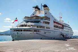
Given its coastal access and Mediterranean climate, Sarandë has become an important tourist attraction since the fall of communism in Albania. Saranda as well as the rest of the Albanian Riviera, according to The Guardian, "is set to become the new undiscovered gem of the overcrowded Med."[47] Tourism is thus the major economic resource, while other resources include services, fisheries and construction. The unemployment rate according to the population census of 2008 was 8.32%. It has been suggested that family tourism and seasonal work during the summer period help mitigate the real unemployment rate. Recently, the town has experienced an uncontrolled construction boom which may hamper the city's future tourism potential. Since 2012, the Port of Saranda is undergoing an expansion to accommodate cruise ships at its terminal.
Tourism
Tourism is the main driver of the economy of Sarandë. It is a significant tourist destination on the Ionian Sea, and by far one of the most popular destination in Albania.
It's a prosperous region with varied attractions, plants and mountains, rivers and lakes, springs and virgin beaches, citrus plantations, olive groves and vineyards, pastures and woods, fish and shellfish farming, desirable hunting places. In short, the right place for the development of tourism. Saranda's stony beaches are quite decent and there are plenty of sights in and around town, including the mesmerising ancient archaeological site of Butrint and the hypnotic Blue Eye Spring. Between Saranda and Butrint, the lovely beaches and islands of Ksamil are perfect for a dip after a day of exploring.[48]
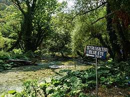 The Blue Eye Spring
 The view over the city and the Port of Sarandë
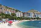
 Promenade with the beach
Notable people
- Antonia Stergiou
- Laert Vasili
- Luiza Xhuvani
International relations
Saranda has cooperation agreements with the following cities/regions:[49]
References
Notes
- Pettifer, James. The Greek Minority in Albania – In the Aftermath of Communism. Conflict Studies Research Center, July 2001 Archived 20 June 2009 at the Wayback Machine ISBN 1-903584-35-3 – p. 12, "The concentration of ethnic Greeks in and around centres of Hellenism such as Saranda and Gjirokastra could guarantee their election there, but nowhere else in the country is success for an Omonia-based candidate possible."
- E.g., Walker, J. & C. "Turkey II: Containing the Northern Part of Greece." Published 1 November 1829 by Baldwin & Cradock, 47 Paternoster Row, London. (London: Chapman & Hall, 1844). Accessed 24 August 2011.
- Murzaku, Ines Angeli (2009). Returning Home to Rome – The Basilian Monks of Grottaferrata in Albania. Analekta Kryptoferris. p. 220. ISBN 978-88-89345-04-7.
- Pearson, Owen (2004). Albania and King Zog: independence, republic and monarchy 1908–1939. I.B.Tauris. p. 470. ISBN 978-1-84511-013-0.
- E.g., Wojskowe Zaklady Kartograficzne. Pergamon World Atlas. "Albania, Greece." Pergamon Press, Ltd. & P.W.N. Poland 1967. Sluzba Topograficzna W.P. Accessed 24 August 2011.
- Georgiev, Vladimir (1966). "The Genesis of the Balkan Peoples". The Slavonic and East European Review. 44 (103): 288. ISSN 0037-6795. JSTOR 4205776.
The Proto Greek region... Study of toponyms shows clearly that this region lay approximately in north-western Greece. The proofs are as follows: ... Almost all toponyms, especially the most important ones from this region, are of Greek origin and they often show archaic Greek features. Toponyms: ... Ογχεσμός
- Crossland, R. A.; Birchall, Ann (1973). Bronze Age migrations in the Aegean; archaeological and linguistic problems in Greek prehistory: Proceedings of the first International Colloquium on Aegean Prehistory, Sheffield. Duckworth. p. 248. ISBN 978-0-7156-0580-6.
Proto Greek: ... Onkhesmos; Aeolic = Attic.... 'ana-khoe', 'volcanic eruption'
- Bejko, Lorenc (2002). "Mycenaean Presence and Influence in Albania". Greek Influence Along the East Adriatic Coast. Kniževni Krug: 12. ISBN 9789531631549. Retrieved 4 April 2020.
- Strabo, The Geography, Book VII, Chapter 7.5: "...these mountains one comes to Onchesmus, another harbor, opposite which lie the western extremities of Corcyraea."
- Ptolemy. The Geography. 3.14.2.
- Hammond, N.G.L. Philip of Macedon. London, UK: Duckworth, 1994. "Epirus was a land of milk and animal products...The social unit was a small tribe, consisting of several nomadic or semi-nomadic groups, and these tribes, of which more than seventy names are known, coalesced into large tribal coalitions, three in number: Thesprotians, Molossians and Chaonians...We know from the discovery of inscriptions that these tribes were speaking the Greek language (in a West-Greek dialect)."
- Talbert, Richard J.A. and Bagnall, Roger S. Barrington Atlas of the Greek and Roman World, 2000, p. 815. "harbor, cape or town in Epirus between Onchesmos and Bouthroton."
- Eidinow, Esther. Oracles, Curses, and Risk Among the Ancient Greeks. Oxford University Press, 2007. ISBN 0-19-927778-8 "Onchesmos was the principal port of Phoinike, the capital of Chaonia,..."
- Cic. Att. 7.2
- Dionysius of Halicarnassus, Ant. Rom. 1.51
- Bowden, William. Epirus Vetus: The Archaeology of a Late Antique Province. London: Duckworth, 2003, ISBN 0-7156-3116-0, p. 14. "Anchiasmos (Onchesmos)"
- Hodges, Richard. Saranda – Ancient Onchesmos: A Short History and Guide. Butrint Foundation, 2007. ISBN 99943-943-6-3
- James K. Aitken; James Carleton Paget (20 October 2014). The Jewish-Greek Tradition in Antiquity and the Byzantine Empire. Cambridge University Press. p. 22. ISBN 978-1-107-00163-3.
The remains of a late antique synagogue were discovered in Saranda (ancient Onchesmos)... The synagogue has been dated to the fourth-fifth century. It was supplanted by a Christian church in the sixth century
- Ariel Scheib. "Albania Virtual Jewish History Tour".
- M. V. Sakellariou. Epirus, 4000 years of Greek history and civilization. Ekdotike Athenon. ISBN 978-960-213-371-2, p. 153.
- M. V. Sakellariou. Epirus, 4000 years of Greek history and civilization. Ekdotike Athenon. ISBN 978-960-213-371-2, p. 164.
- Hodges, Richard (2007). Saranda, Ancient Onchesmos: A Short History and Guide. Migjeni Publishing House. p. 16. ISBN 9789994394364.
- Kokolakis, Mihalis (2003). Το ύστερο Γιαννιώτικο Πασαλίκι: χώρος, διοίκηση και πληθυσμός στην τουρκοκρατούμενη Ηπειρο (1820–1913) [The late Pashalik of Ioannina: Space, administration and population in Ottoman ruled Epirus (1820–1913)]. Athens: EIE-ΚΝΕ. p. 204. ISBN 960-7916-11-5.CS1 maint: ref=harv (link) "Ένα ακόμα μουδιρλίκι λειτούργησε στο εσωτερικό του καζά του Δελβίνου ύστερα από τη μεταρρύθμιση του 1867: το μουδιρλίκι των Αγίων Σαράντα. Η ιδιορρυθμία της διοικητικής αυτής μονάδας ήταν ότι δεν υπαγόταν σ' αυτήν κανένα χωριό, παρά μόνο το λιμάνι των Αγίων Σαράντα, το οποίο παρέμεινε μέχρι το τέλος της Τουρκοκρατίας απλός εμπορικός σταθμός, χωρίς μόνιμους κατοίκους και θεσμοθετημένη κοινοτική οργάνωση. Η τοποθέτηση του μουδίρη έχει άμεση σχέση με την επιθυμία των οθωμανικών αρχών να αναβαθμίσουν αυτό το λιμάνι, μειώνοντας την οικονομική εξάρτηση της βορειότερης Ηπείρου από την Πρέβεζα και τα Γιάννενα.
- M. V. Sakellariou. Epirus, 4000 years of Greek history and civilization. Ekdotike Athenon. ISBN 978-960-213-371-2, p. 292.
- Hodges, Richard (July 2007). Saranda – Ancient Onchesmos: A Short History and Guide. Butrint Foundation. p. 17. ISBN 978-9994394364.
- Pyrrhus J. Ruches (1965). Albania's Captives. Argonaut.
- Kondis, Basil (1976). Greece and Albania: 1908–1914. Thessaloniki: Institute for Balkan Studies, New York University.
Zographos and Karapanos met at Santi Quaranda with the Commission but upon the request of Zographos the final negotiations took place in the island of Corfu... Protocol of Corfu
- Edith Pierpont Stickney. Southern Albania or northern Epirus in European international affairs, 1912–1923 Stanford University Press, 1926.
- Rothschild, Joseph (1974). East Central Europe between the Two World Wars. University of Washington Press. p. 360. ISBN 978-0-295-80364-7.CS1 maint: ref=harv (link)
- Carr, John (2013). The Defence and Fall of Greece 1940–1941. Pen and Sword. pp. 78–79. ISBN 978-1-4738-2830-8.
This made the Greek war effort immeasurably easier ... overland route.
- Fischer, Bernd J. (1999). Albania at war : 1939–1945. London: Hurst. pp. 232–233. ISBN 978-1-85065-531-2.
- Giakoumis, Georgios K. (1996). Monuments of Orthodoxy in Albania. Doukas School. p. 148. ISBN 9789607203090.
The Beautiful harbour of Ayii Saranda... In this harbour stood the church of Saint Spyridon, which was demolished under Enver Hoxha. A temporary wooden hut-shrine was erected in its place in 1991. The locals have laid claims to the site in order to rebuilt their church. This is not a straightforward matter, however, because the inhabitants of the town are no longer exclusively Christians. Under the settlement policy pursued by Hoxha, thousands of Muslims were transferred from the north of Albania in order to alter the ethnic composition of the region.
- Petiffer, James. "The Greek Minority in Albanian in the Aftermatch of Communism" (PDF). Retrieved 19 May 2018.
he Greek minority in Saranda scored the first military success for the opposition by capturing a government tank on March 6.
- "Grand Hotel Saranda". grandhotelsaranda.com.
- Law nr. 115/2014
- Sarande Municipality. "Historiku i Qytetit" (in Albanian). Archived from the original on 6 July 2011. Retrieved 28 July 2010.
- "Population and housing census - Vlorë 2011" (PDF). INSTAT. Retrieved 25 September 2019.
- "Correspondence table LAU – NUTS 2016, EU-28 and EFTA / available Candidate Countries" (XLS). Eurostat. Retrieved 25 September 2019.
- "Vlora's communes". Retrieved 13 January 2016.
- Council of Europe. "Report Submitted by Albania" (PDF). Retrieved 28 July 2010.
According to a survey held last year by the Albanian Helsinki Committee, until 1990, the city of Saranda had about 17 thousand inhabitants, with nearly 7,500 of them belonging to Greek national minority.
- Paik, Charles M. Vance, Yongsun (2006). Managing a global workforce challenges and opportunities in international human resource management. Armonk, N.Y.: M.E. Sharpe. p. 682. ISBN 9780765620163.
- Kallivretakis, Leonidas (1995). "Η ελληνική κοινότητα της Αλβανίας υπό το πρίσμα της ιστορικής γεωγραφίας και δημογραφίας [The Greek Community of Albania in terms of historical geography and demography." In Nikolakopoulos, Ilias, Kouloubis Theodoros A. & Thanos M. Veremis (eds). Ο Ελληνισμός της Αλβανίας [The Greeks of Albania]. University of Athens. p. 34. "Στα πλαίσια της επιτόπιας έρευνας που πραγματοποιήσαμε στην Αλβανία (Νοέμβριος-Δεκέμβριος 1992), μελετήσαμε το ζήτημα των εθνοπολιτισμικών ομάδων, όπως αυτές συνειδητοποιούνται σήμερα επί τόπου. [As part of the fieldwork we held in Albania (November–December 1992), we studied the issue of ethnocultural groups, as they are realized today on the spot.] "; pp. 42–43. "Οι πιθανοί συνδυασμοί αναδεικνύουν την κομβική θέση των Αλβανών Χριστίανών, γεγονός που έχει γίνει αντιληπτό από μερίδα της μειονοτικής ηγεσίας. [Οι πιθανοί συνδυασμοί αναδεικνύουν την κομβική θέση των Αλβανών Χριστίανών, γεγονός που έχει γίνει αντιληπτό από μερίδα της μειονοτικής ηγεσίας.]"; p. 43. "Το ίδιο ισχύει και στην περίπτωση των Αγίων Σαράντα, αν και ο Δήμος πέρασε στα χέρια της μειονότητας, χάρις στις ψήφους των Αλβανών Χριστιανών. [The same applies in the case of Saranda, though the municipality passed into the hands of the minority, thanks to the votes of Albanian Christians.]"; p. 51. "Ε Έλληνες, ΑΧ Αλβανοί Ορθόδοξοι Χριστιανοί, AM Αλβανοί Μουσουλμάνοι, Μ Μικτός πληθυσμός.... SARANDE ΣΑΡΑΧΤΙ (ΑΓ. ΣΑΡΑΝΤΑ) 17555 Μ(8055 AM + 6500 Ε + 3000 ΑΧ)."
- Kallivretakis, Leonidas (1995). "Η ελληνική κοινότητα της Αλβανίας υπό το πρίσμα της ιστορικής γεωγραφίας και δημογραφίας [The Greek Community of Albania in terms of historical geography and demography." In Nikolakopoulos, Ilias, Kouloubis Theodoros A. & Thanos M. Veremis (eds). Ο Ελληνισμός της Αλβανίας [The Greeks of Albania]. University of Athens. Pages: 51
- Pettifer, James. The Greek Minority in Albania – In the Aftermath of Communism. Conflict Studies Research Center, July 2001 Archived 20 June 2009 at the Wayback Machine ISBN 1-903584-35-3 – p. 11, "In 1991, Greek shops were attacked in the coastal town of Saranda, home to a large minority population, and inter-ethnic relations throughout Albania worsened."
- "Fourth Report submitted by Albania pursuant to Article 25, paragraph 2 of the Framework Convention for the Protection of National Minorities". Ministry of Foreign Affairs, Republic of Albania. p. 98. Retrieved 28 December 2018.
- Human rights in post-communist Albania, Fred Abrahams, Human Rights Watch, p.119 "The town of Saranda has an ethnic Greek population large enough to warrant a school, but one still does not exist".
- 2009's hot new beach destination: Albania, www.guardian.co.uk
- Planet, Lonely. "Saranda, Albania – Lonely Planet". lonelyplanet.com.
- "Bashkia Binjakezime". bashkiasarande.gov.al. Retrieved 31 May 2019.
![]()
| ||||||||||||||||||||||||||||||||||||||||||||||||||||||||||||||||||||||||||||||||||