Nakhon Si Thammarat
Nakhon Si Thammarat (Thai: นครศรีธรรมราช, pronounced [ná(ʔ).kʰɔ̄ːn sǐː tʰām.má.râːt]; from Pali Nagara Sri Dhammaraja) is a city (thesaban nakhon) in southern Thailand, capital of the Nakhon Si Thammarat Province and the Nakhon Si Thammarat District. It is about 610 km (380 mi) south of Bangkok, on the east coast of the Malay Peninsula. The city was the administrative center of southern Thailand during most of its history. Originally a coastal city, silting moved the coastline away from the city. The city has a much larger north to south extension than west to east, which dates back to its original location on a flood-save dune. The modern city centre on the train station is north of Old Town. As of 2019, the city had a population of 102,152.[1]
Nakhon Si Thammarat นครศรีธรรมราช | |
|---|---|
| City of Nakhon Si Thammarat เทศบาลนครนครศรีธรรมราช | |
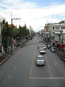 Ratchadamnoen St, Nakhon Si Thammarat | |
 Seal | |
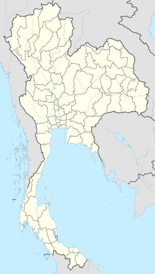 Nakhon Si Thammarat Location in Thailand | |
| Coordinates: 8°26′11″N 99°57′47″E | |
| Country | |
| Province | Nakhon Si Thammarat |
| District | Mueang Nakhon Si Thammarat |
| Sanitation | 5 Sept 1913 |
| Town municipality | 11 Dec 1935 |
| City municipality | 25 Aug 1994 |
| Government | |
| • Type | City Municipality |
| • Mayor | Chaowawat Saenpong (since 2011) |
| Area | |
| • Total | 22.56 km2 (8.71 sq mi) |
| Area rank | 19th |
| Elevation | 9 m (30 ft) |
| Population (2019)[1] | |
| • Total | 102,152 |
| • Rank | 12th |
| • Density | 4,528/km2 (11,730/sq mi) |
| Registered residents | |
| Time zone | UTC+7 (ICT) |
| Postcode | 80000 |
| Calling ode | 075 |
| Website | www |
Toponymy
Thai honorific Sri or Si is from Sanskrit Sri; Thamma, from Dharma; rat, from Raja. Dhammaraja means "righteous ruler", an important Theravada concept.
History
It is one of the most ancient cities of Thailand, previously the Kingdom of Ligor, and contains many buildings and ruins of historical significance.
The king of Srivijaya "had established a foothold on the Malay Peninsular at Ligor" by 775, where he "built various edifices, including a sanctuary dedicated to the Buddha and to the Bodhisattvas Padmapani and Vajrapani." [2]:84–85,91
With the fall of the Siamese capital of Ayutthaya in 1767 it regained independence, but returned to its allegiance on the founding of Bangkok. In the 17th century British, Portuguese, and Dutch merchants set up factories there and carried on an extensive trade. Its origins are not fully known. Most historians recognize the Tambralinga Kingdom of Chinese records as a precursor of Nakhon Si Thammarat.
The town chronicles of this time are hardly separable from legend, but they do tell of an abandonment and refounding of the town, which would explain the break in history between Tambralinga and Nakhon Si Thammarat.
References to a country named Poling appear in Chinese chronicles from the Tang dynasty period down to the early Ming dynasty. Many scholars identify Poling with Maling and Danmaling was one of the member-states of Sanfoqi (the Chinese equivalent to Srivijaya) in the central part of the Malayu Peninsula or today southern Thailand.
Poling may also be equated to the Tambralingarat (Tambralinga State) that appears in Indian sources. By the end of the 12th century, Tambralinga had become independent of Srivijaya Kingdom. Its rapid rise to prominence from the 13th century to the beginning of the 14th century, Tambralinga had occupied the entire Malay Peninsula and become one of the dominant south-east Asian states. By the end of the 14th century, Tambralinga had become a part of Siam (now Thailand) named Nakhon Si Thammaraj.
At the time of the Sukhothai Kingdom, the Nakhon Si Thammarat Kingdom was already listed as one of the kingdoms under control of the Thai, which it has remained during most of its history. It was usually known as Ligor to European merchants in the 16th century.
During the period of the five separate states following the fall of Ayutthaya in 1767, the Prince of Nakhon Si Thammarat made an abortive bid for independence, but was pardoned by Taksin and retired to Thonburi.
At the end of the 19th century, the kingdom was finally fully absorbed into Siam by converting it into the Monthon Nakhon Si Thammarat. When the monthon system was abolished in 1932, the town became a provincial capital.
Climate
Nakhon Si Thammarat has a tropical rainforest climate (Köppen climate classification Af). The city is more subject to the Intertropical Convergence Zone than the trade winds but experiences a few cyclones so is not purely equatorial but subequatorial. Temperatures remain very warm to hot throughout the year. While some rain falls in all months, it is drier in February and March when about 90 millimetres (3.5 in) of rain falls in each month, and wetter in October to December when very heavy rain may fall; November sees 631 millimetres (24.8 in) of rain on average each year.
| Climate data for Nakhon Si Thammarat (1981–2010) | |||||||||||||
|---|---|---|---|---|---|---|---|---|---|---|---|---|---|
| Month | Jan | Feb | Mar | Apr | May | Jun | Jul | Aug | Sep | Oct | Nov | Dec | Year |
| Record high °C (°F) | 34.4 (93.9) |
35.5 (95.9) |
37.6 (99.7) |
38.9 (102.0) |
38.1 (100.6) |
37.8 (100.0) |
38.5 (101.3) |
37.6 (99.7) |
37.7 (99.9) |
35.8 (96.4) |
35.4 (95.7) |
32.7 (90.9) |
38.9 (102.0) |
| Average high °C (°F) | 30.4 (86.7) |
31.5 (88.7) |
32.9 (91.2) |
34.0 (93.2) |
34.0 (93.2) |
34.0 (93.2) |
33.8 (92.8) |
33.7 (92.7) |
33.1 (91.6) |
31.8 (89.2) |
30.2 (86.4) |
29.6 (85.3) |
32.4 (90.3) |
| Daily mean °C (°F) | 26.0 (78.8) |
26.5 (79.7) |
27.4 (81.3) |
28.4 (83.1) |
28.2 (82.8) |
28.2 (82.8) |
27.9 (82.2) |
27.8 (82.0) |
27.3 (81.1) |
26.7 (80.1) |
26.1 (79.0) |
25.7 (78.3) |
27.2 (81.0) |
| Average low °C (°F) | 22.1 (71.8) |
22.0 (71.6) |
22.7 (72.9) |
23.7 (74.7) |
24.0 (75.2) |
24.0 (75.2) |
23.6 (74.5) |
23.5 (74.3) |
23.2 (73.8) |
23.1 (73.6) |
23.0 (73.4) |
22.5 (72.5) |
23.1 (73.6) |
| Record low °C (°F) | 18.0 (64.4) |
17.6 (63.7) |
18.3 (64.9) |
20.2 (68.4) |
21.1 (70.0) |
19.6 (67.3) |
20.1 (68.2) |
20.8 (69.4) |
20.0 (68.0) |
20.6 (69.1) |
18.9 (66.0) |
18.0 (64.4) |
17.6 (63.7) |
| Average rainfall mm (inches) | 145.4 (5.72) |
68.0 (2.68) |
89.7 (3.53) |
107.0 (4.21) |
173.8 (6.84) |
117.3 (4.62) |
117.8 (4.64) |
129.8 (5.11) |
161.6 (6.36) |
303.0 (11.93) |
631.2 (24.85) |
451.6 (17.78) |
2,496.3 (98.28) |
| Average rainy days | 12.5 | 5.1 | 7.3 | 8.6 | 16.5 | 13.0 | 13.9 | 14.4 | 17.2 | 20.5 | 21.1 | 19.2 | 169.4 |
| Average relative humidity (%) | 84 | 81 | 80 | 80 | 81 | 79 | 79 | 78 | 82 | 85 | 87 | 86 | 82 |
| Mean monthly sunshine hours | 179.8 | 180.8 | 201.5 | 183.0 | 155.0 | 150.0 | 155.0 | 114.7 | 108.0 | 108.5 | 105.0 | 142.6 | 1,783.9 |
| Mean daily sunshine hours | 5.8 | 6.4 | 6.5 | 6.1 | 5.0 | 5.0 | 5.0 | 3.7 | 3.6 | 3.5 | 3.5 | 4.6 | 4.9 |
| Source 1: Thai Meteorological Department[3] | |||||||||||||
| Source 2: Office of Water Management and Hydrology, Royal Irrigation Department (sun and humidity)[4] | |||||||||||||
Administration
| Subdistrict | Comm. | People | Househ. |
|---|---|---|---|
| Nai Mueang | 20 | 42,398 | 18,832 |
| Pho Sadet | 18 | 24,664 | 11,052 |
| Khlang | 11 | 17,040 | 8,226 |
| Tha Wang | 13 | 16,854 | 7,563 |
| Nakian | 1 | 1,196 | 472 |
Nakhon Si Thammarat was established as a sanitation (sukhaphiban) on 5 September 1913, with an area of 3.0 sq.km.[5] The sanitation changed to town municipality (thesaban mueang) on 11 December 1935.[6] The municipality was increased to 11.72 sq.km. on 10 November 1965,[7] and up to 22.56 sq.km. on 10 December 1993.[8] The status was upgraded to city municipality (thesaban nakhon) on 25 August 1994.[9] The administration consists of five subdistricts, 63 communities, 102,152 people in 46,145 households.
Points of interest
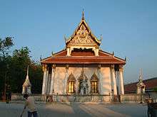
Wat Phra Mahathat Woramahawihan
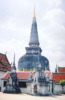
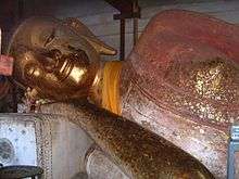
Wat Phra Mahathat Vihan (Thai วัดพระมหาธาตุวรมหาวิหาร) is the most important temple of Nakhon Si Thammarat and southern Thailand. It was constructed at the time of the founding of the town, and contains a tooth relic of Buddha. The 78 m high chedi is surrounded by 173 smaller ones. While the chedi is now in Sri Lankan style, it is said to be built on top of an earlier Srivijaya style chedi. The chedi was renovated in early 2009 and now appears like new.
At the base of the chedi is a gallery named Viharn Tap Kaset, decorated with many Buddha statues and elephant heads emerging from the chedi. Viharn Phra Song Ma are the buildings which contain the staircase which leads to a walkway around the chedi above the gallery. At the bottom of the staircase are demon giants (yak) as guardians. Adjoining to the north is the Viharn Kien, which contains a small temple museum.
South of the chedi is the large ubosot building, the Viharn Luang. Monk living quarters are across the street in a separate temple, Wat Na Phra Boromathat.
The chedi is the symbol of the Nakhon Si Thammarat Province, present on the seal of the province. It is also displayed on the 25 satang coin.
City wall
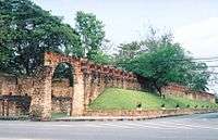
The city chronicle mentions a fortification when the town was refounded in 1278. Restorations were recorded at the time of King Ramesuan (14th century), as well as King Narai (1686). The latter was supported by the French engineer M. de la Mare.
The walls spread 456 m from east to west, and 2238 m north to south, thus enclosing an area of about one square kilometre. The northern wall had only one gate, called Prathu Chai Nua or Prathu Chai Sak. The southern wall had only one gate. To the east there were three gates, which connected the town with the sea. To the west were five gates. Today only the northern gate still exists, together with a short stretch of the northern city wall.
Educational institutions
Kindergarten and primary schools: Anuban Na Nakhon Utit School is a government-run school with kindergarten through grade 6. The school operates both Thai and English programmes.
Sithammarat Suksa School is the largest kindergarten and primary school. They offer nursery-grade 6 classes on all three campuses in the city. They also offer the largest English program housed on a separate campus. Sithammart Suksa is often referred to as "Sirat" "AMC" or "EP AMC".
Secondary schools: Nakhon Si Thammarat has three large schools: Benjamarachutit School and Kanlayanee Si Thammarat School, both public secondary schools with grades 7 to 12, and Sithammarat Suksa School, the largest private pre-kindergarten through grade 12 school.
Vocational Colleges: Nakhon Si Thammarat has numerous vocational colleges, the most notable being Nakhon Si Thammaratt Technical College (Technic), and Nakhon Si Thammarat Vocational college (Acheewa).
Universities: Nakhon Si Thammarat has two universities: Walailak University (the largest university in Thailand) and Nakhon Si Thammarat Rajaphat University.
References
- "รายงานสถิติจำนวนประชากรและบ้านประจำปี พ.ศ.2562" [Statistics, population and house statistics for the year 2019]. Registration Office Department of the Interior, Ministry of the Interior (in Thai). 31 December 2019. Retrieved 10 March 2020, archiving is not necessary because DOPA provides data from 1993 to future years.
- Coedès, George (1968). Walter F. Vella (ed.). The Indianized States of south-east Asia. trans.Susan Brown Cowing. University of Hawaii Press. ISBN 978-0-8248-0368-1.
- "Climatological Data for the Period 1981–2010". Thai Meteorological Department. p. 24. Retrieved 8 August 2016.
- "ปริมาณการใช้น้ำของพืชอ้างอิงโดยวิธีของ Penman Monteith (Reference Crop Evapotranspiration by Penman Monteith)" (PDF) (in Thai). Office of Water Management and Hydrology, Royal Irrigation Department. p. 111. Retrieved 8 August 2016.
- "ประกาศใช้พระราชบัญญัติศุขาภิบาล นครศรีธรรมราช ร.ศ.๑๒๙" [Announcement of the Sanitation Act Re: Nakhon Si Thammarat Rattanakosin Era 129 (1913)] (PDF). Royal Thai Government Gazette. 27: 62–64. 4 September 1913. Retrieved 10 April 2020, effectively on 5 September 1913
- "พระราชกฤษฎีกา จัดตั้งเทศบาลเมืองครรศรีธรรมราช จังหวัดนครศรีธรรมราช พ.ศ.๒๔๗๘" [Royal Decree Establish of Nakhon Si Thammarat Town Municipality, Nakhon Si Thammarat Province, B.E.2478 (1935)] (PDF). Royal Thai Government Gazette. 52: 1687–1691. 10 December 1935. Retrieved 10 April 2020, effectively on 11 December 1935
- "พระราชกฤษฎีกา เปลี่ยนเปลงเขตเทศบาลเมืองนครศรีธรรมราช จังหวัดนครศรีธรรมราช พ.ศ.๒๕0๘" [Royal Decree Change Territory of Nakhon Si Thammarat Town Municipality, Nakhon Si Thammarat Province, B.E.2508 (1965)] (PDF). Royal Thai Government Gazette. 82 (96): 1061–1065. 9 November 1965. Retrieved 10 April 2020, effectively on 10 November 1965
- "พระราชกฤษฎีกา เปลี่ยนเปลงเขตเทศบาลเมืองนครศรีธรรมราช จังหวัดนครศรีธรรมราช (ฉบับที่ ๒) พ.ศ.๒๕0๖" [Royal Decree Change Territory of Nakhon Si Thammarat Town Municipality, Nakhon Si Thammarat Province, (Issue 2) B.E.2536 (1993)] (PDF). Royal Thai Government Gazette. 110 (207): 37–40. 9 December 1993. Retrieved 10 April 2020, effectively on 10 December 1993
- "พระราชกฤษฎีกา จัดตั้งเทศบาลนครนครศรีธรรมราช จังหวัดนครศรีธรรมราช พ.ศ. ๒๕๓๗" [Royal Decree of Nakhon Si Thammarat City Municipality, Nakhon Si Thammarat Province, Buddhist Era 2537 (1994)] (PDF). Royal Thai Government Gazette. 111 (36 Kor): 30–34. 24 August 1994. Retrieved 10 April 2020, effectively on 25 August 1994
- Stuart Munro-Hay. Nakhon Sri Thammarat – The Archaeology, History and Legends of a Southern Thai Town. ISBN 974-7534-73-8
External links

| Wikimedia Commons has media related to Nakhon Si Thammarat. |
| 1,000,000 and more |
|
|---|---|
| 500,000–999,999 |
|
| 200,000–499,999 |
|
| 100,000–299,999 | |
| Authority control |
|
|---|