Lejbailat
Lejbailat (Arabic: لجبيالت; also spelled Al Jubailat and Al Jebailat) is a district in Qatar, located in the municipality of Doha.[2] It has a relatively higher elevation compared to the rest of Doha and provides a vantage point of West Bay, one of Doha's main commercial districts. Imam Muhammad ibn Abd al-Wahhab Mosque, Qatar's state mosque, is situated in the district.[3]
Lejbailat لجبيالت | |
|---|---|
District | |
 View of Lejbailat and the Imam Muhammad ibn Abd al-Wahhab Mosque (State Mosque) | |
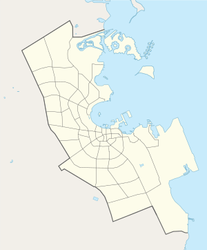 Lejbailat 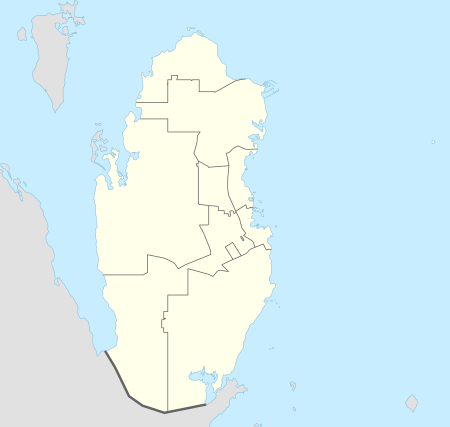 Lejbailat | |
| Coordinates: 25°19′14″N 51°30′19″E | |
| Country | |
| Municipality | Ad-Dawhah |
| Zone | Zone 64 |
| District no. | 104 |
| Area | |
| • Total | 1.4 km2 (0.5 sq mi) |
| Population | |
| • Total | 4,024 |
| • Density | 2,900/km2 (7,400/sq mi) |
Embassies
Lejbailat hosts the following embassies:[4]


Transport
Major roads that run through the district are Abdul Aziz Bin Jassim Street, Khalifa Street, Al Markhiya Street and Onaiza Street.[5]
Demographics
As of the 2010 census, the district comprised 605 housing units[6] and 53 establishments.[7] There were 4,024 people living in the district, of which 52% were male and 48% were female. Out of the 4,024 inhabitants, 74% were 20 years of age or older and 26% were under the age of 20. The literacy rate was 98.4%.[8]
Employed persons made up 57% of the total population. Females accounted for 40% of the working population, while males accounted for 60% of the working population.[8]
| Year | Population |
|---|---|
| 1986[9] | 1,309 |
| 1997[10] | 2,276 |
| 2004[11] | 2,814 |
| 2010[2] | 4,024 |
Education
The following school is located in Lejbailat:
| Name of School | Curriculum | Grade | Genders | Official Website | Ref |
|---|---|---|---|---|---|
| Al Dana Private Kindergarten | Independent | Kindergarten | Both | N/A | [12] |
Gallery
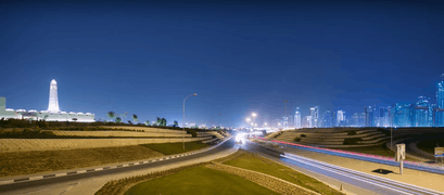 Gently sloping hillocks in Lejbailat.
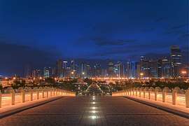 View from Imam Muhammad ibn Abd al-Wahhab Mosque, overlooking West Bay.
References
- "District Area Map". Ministry of Development Planning and Statistics. Retrieved 1 March 2019.
- "2010 population census" (PDF). Qatar Statistics Authority. Archived from the original (PDF) on 2 April 2015. Retrieved 29 June 2015.
- "Attractions in Doha Qatar". Online Qatar. Retrieved 30 July 2018.
- "Embassies". Ministry of Interior (Qatar). Retrieved 27 August 2018.
- "Index map of Qatar". ArcGIS.com. Retrieved 30 August 2019.
- "Housing units, by type of unit and zone (April 2010)" (PDF). Qatar Statistics Authority. Archived from the original (PDF) on 8 July 2015. Retrieved 7 August 2015.
- "Establishments by status of establishment and zone (April 2010)" (PDF). Qatar Statistics Authority. Archived from the original (PDF) on 8 July 2015. Retrieved 7 August 2015.
- "Geo Statistics Application". Ministry of Development Planning and Statistics. Archived from the original on 11 September 2012. Retrieved 7 August 2015.
- "1986 population census" (PDF). Qatar Statistics Authority. Archived from the original (PDF) on 3 July 2015. Retrieved 2 July 2015.
- "1997 population census" (PDF). Qatar Statistics Authority. Archived from the original (PDF) on 29 May 2015. Retrieved 2 July 2015.
- "2004 population census". Qatar Statistics Authority. Archived from the original on 24 September 2015. Retrieved 1 July 2015.
- "Al Dana Private Kindergarten". Supreme Education Council. Archived from the original on 24 September 2015. Retrieved 18 July 2015.