Al Thumama (Doha)
Al Thumama (Arabic: الثمامة, romanized: ath-Thumāma) is a district of both the municipalities of Doha and Al Wakrah in Qatar.[2] It is one of five sites for the government-sponsored project to develop reservoirs in the country.[3] The reservoirs, once completed at the estimated date of 2017, are expected to be the largest in the world in their category.[4] It is one of the proposed venues for the Qatar 2022 World Cup.[5]
Al Thumama الثمامة | |
|---|---|
District | |
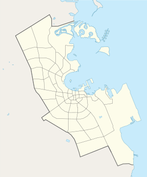
 Aerial view of Zone 47 of Al Thumama, with Airport Street in the foreground, in 2014. | |
 Al Thumama 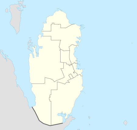 Al Thumama | |
| Coordinates: 25°13′47″N 51°32′45″E | |
| Country | |
| Municipality | Doha / Al Wakrah |
| Zone | Zone 46, Zone 47 |
| District no. | 45 |
| Area | |
| • Total | 7.0 km2 (2.7 sq mi) |
| Elevation | 12 m (39 ft) |
| Population (2010) | |
| • Total | 16,596 |
| • Density | 2,400/km2 (6,100/sq mi) |
As one of Doha's newer districts, the area is well-planned and was laid out according to a strict grid pattern. City authorities first planned the district in the 1990s, and since then it has grown at a fast rate. It is primarily a residential district, with Qataris and Arab expatriates being the most common groups to reside here. Doha's road system is well-connected to the area, with important roads such as the E Ring Road, F Ring Road and Al Matar Street running through it. Furthermore, it is close to Hamad International Airport.[6]
Etymology
The district derives its name from a plant that grows abundantly in the area. Known locally as "thumam" (Latin name Panicum turgidum), it is a sod-forming perennial grass adapted to desert climates.[7]
Transport
Mowasalat is the official transport company of Qatar and serves the community through its operation of public bus routes. Al Thumama serves as the terminus of two bus lines, both of which depart from Al Ghanim Bus Station. Route 10 has stops at Najma and Al Mansoura and a terminus at Al Thumama at Bus Stop 5, running at a frequency of every 30 minutes on all days of the week. The other route, route 11, has stops at Al Najma, Lulu Hyper Market, and Old Airport and a terminus at Al Thumama near the Supreme Education Council, running at frequency of every 20 minutes on all days of the week.[8][9]
Major roads that run through the district are E Ring Road, Airport Street and Al Fadail Street.[10]
Sports
Al Thumama Stadium, a 2022 FIFA World Cup venue, is planned to be built in the district. Designed by Qatari architect Ibrahim Jaidah, it will have a seating capacity of 40,000 spectators and will be designed to mimic a traditional Arabic cap known as a gahfiya.[5]
Demographics
As of the 2010 census, the district comprised 3,451 housing units[11] and 124 establishments.[12] There were 16,596 people living in the district, of which 63% were male and 37% were female. Out of the 16,596 inhabitants, 75% were 20 years of age or older and 25% were under the age of 20.[13]
Employed persons made up 63% of the total population. Females accounted for 24% of the working population, while males accounted for 76% of the working population.[13]
Gallery
 Al Meera Supercenter on Al Hadra Street in Al Thumama.
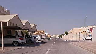 Ibn Al Baitar Street in Al Thumama.
References
- "Al Thumama 46, Zone 46, Qatar on the Elevation Map". elevationmap.net. Retrieved 14 January 2019.
- "2010 population census" (PDF). Qatar Statistics Authority. Archived from the original (PDF) on 2 April 2015. Retrieved 7 August 2015.
- "رئيس الوزراء: يطلق مشروع الخزانات الاستراتيجية الكبرى لتأمين المياه". Qatar Government. 13 May 2015. Retrieved 17 December 2015.
- Amery, Hussain A. (15 June 2015). Arab Water Security: Threats and Opportunities in the Gulf States. Cambridge University Press. p. 121.
- Saraiva, Alexia. "Get To Know The 8 2022 Qatar World Cup Stadiums". ArchDaily.
- Reem Awwad (January 2017). Assessment of neighborhood vitality in Doha (Thesis). Qatar University. pp. 98–100. Retrieved 10 November 2019.
- "District map". The Centre for Geographic Information Systems of Qatar. Retrieved 1 January 2019.
- "Route Maps". Qatar Transit Guide. Retrieved 21 January 2019.
- "Qatar Public Transport Program (QPTP)". Ministry of Transport and Communications. Retrieved 21 January 2019.
- "Index map of Qatar". ArcGIS.com. Retrieved 30 August 2019.
- "Housing units, by type of unit and zone (April 2010)" (PDF). Qatar Statistics Authority. Archived from the original (PDF) on 8 July 2015. Retrieved 7 August 2015.
- "Establishments by status of establishment and zone (April 2010)" (PDF). Qatar Statistics Authority. Archived from the original (PDF) on 8 July 2015. Retrieved 7 August 2015.
- "Geo Statistics Application". Ministry of Development Planning and Statistics. Archived from the original on 2012-09-11. Retrieved 7 August 2015.
| Zone 90 |
|
|---|---|
| Zone 91 |
|
| Zone 92 |
|
| Zone 93 | |
| Zone 94 | |
| Zone 95 | |
| Zone 98 | |