Latani, Dhanbad
Latani is a village in Purbi Tundi CD block in Dhanbad Sadar subdivision of Dhanbad district in the Indian state of Jharkhand.
- This page is about a village in Jharkhand, India. Latani redirects to Cleverman, an Australian television drama program
Latani | |
|---|---|
Village | |
 Latani Location in Jharkhand, India  Latani Latani (India) | |
| Coordinates: 23.889194°N 86.587611°E | |
| Country | |
| State | Jharkhand |
| District | Dhanbad |
| Population (2011) | |
| • Total | 1,762 |
| Languages | |
| • Official | Hindi, Urdu |
| Time zone | UTC+5:30 (IST) |
| Website | dhanbad |
Geography
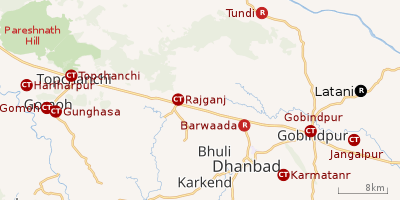 |
| Cities, towns and locations in the northern portion of Dhanbad Sadar subdivision in Dhanbad district MC: Municipal Corporation, CT: Census Town, N: Neighbourhood, R: Rural/ Urban centre Owing to space constraints in the small map, the actual locations in a larger map may vary slightly |
Location
Latani is located at 23.889194°N 86.587611°E.
Note: The map alongside presents some of the notable locations in the area. All places marked in the map are linked in the larger full screen map.
Overview
The region shown in the map lies to the north of Dhanbad city and is an extensive rural area with villages (particulalrly in the northern areas) scattered around hills. One of the many spurs of Pareshnath Hill (1,365.50 m), situated in neighbouring Giridih district, passes through the Topchanchi and Tundi areas of the district. The Barakar River flows along the northern boundary. The region shown in the map covers several CD blocks – Topchanchi, Govindpur, Tundi, Purbi Tundi and a small part of Baghmara. The Kolkata-Agra National Highway 19 (old number NH 2)/ Grand Trunk Road cuts across the southern part of the region.[1]
Police station
Purvi Tundi police station serves Purbi Tundi CD Block.[2]
CD block HQ
Headquarters of Purbi Tundi CD block is at Latani.[3]
Demographics
As per the 2011 Census of India, Latani had a total population of 1,762 of which 883 (50%) were males and 879 (50%) were females. Population below 6 years was 243. The total number of literates in Latani was 1,039 (68.40% of the population over 6 years).[4]
Transport
Latani is on the Dhanbad-Jamtara Road.[5]
Education
Middle School, Latani was established in 1939. It is a Hindi-medium co-educational school with arrangements for teaching from Class I to Class VIII.[6]
References
- "District Census Handbook Dhanbad" (PDF). Series 21, Part XIIA, pages 4-5, 5-6, 8. Directorate of Census Operations, Jharkhand. Retrieved 4 June 2019.
- "Dhanbad – Welcome to the Coal Capital of India". Administrative Structure of Dhanbad District – List of Thana and Outpost of Dhanbad Outpost. Jharkhand Government. Archived from the original on 24 October 2017. Retrieved 15 October 2017.
- "District Census Handbook 2011 Series 21 Part XIIB" (PDF). Map on Page 3. Directorate of Census Operations, Jharkhand. Retrieved 8 October 2017.
- "2011 Census C.D. Block Wise Primary Census Abstract Data(PCA)". Jharkhand – District-wise CD Blocks. Registrar General and Census Commissioner, India. Retrieved 15 October 2017.
- Google maps
- "Ms Latani School Dhanbad". ICBSE. Retrieved 11 July 2019.