Kaliasole
Kaliasole (also spelled Keliasole) is a village in Nirsa (community development block) in Dhanbad Sadar subdivision of Dhanbad district in the Indian state of Jharkhand.
Kaliasole | |
|---|---|
Village | |
 Kaliasole Location in Jharkhand, India  Kaliasole Kaliasole (India) | |
| Coordinates: 23.7413°N 86.6554°E | |
| Country | |
| State | Jharkhand |
| District | Dhanbad |
| Languages | |
| • Official | Hindi, Urdu |
| Time zone | UTC+5:30 (IST) |
| Website | dhanbad |
Geography
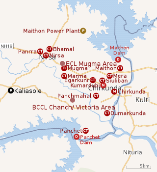 |
| Cities, towns and locations in the eastern portion of Dhanbad Sadar subdivision in Dhanbad district M: Municipality, CT: census town, N: Neighbourhood, R: Rural/ Urban centre, D: Dam, P: Power Plant Owing to space constraints in the small map, the actual locations in a larger map may vary slightly |
Location
Kaliasole is located at 23.7413°N 86.6554°E.
Note: The map alongside presents some of the notable locations in the area. All places marked in the map are linked in the larger full screen map.
Overview
The region shown in the map is a part of the undulating uplands bustling with coalmines. While the Damodar flows along the southern boundary, the Barakar flows along the eastern boundary. Both the rivers form the boundary with West Bengal. Panchet Dam and Maithon Dam, along with their reservoirs, are prominently visible in the map. The entire area is covered in Nirsa (community development block). In Nirsa CD block 69% of the population live in rural areas and 31% live in urban areas. The official website of the district has announced the formation of two new CD blocks – Egarkund and Kaliasole, possibly carved out of Nirsa CD block. As of July 2019, there is no further information about the new CD blocks. BCCL operates Chanch/ Victoria Area partially within the region shown in the map. ECL operates Mugma Area fully within the region shown in the map.[1][2][3]
Demographics
As per the 2011 Census of India, Kaliasole had a total population of 1,985 of which 1,006 (51%) were males and 979 (49%) were females. Population below 6 years was 275. The total number of literates in Kaliasole was 1,320 (77.19% of the population over 6 years).[4]
References
- "District Census Handbook Dhanbad" (PDF). Series 21, Part XIIA, pages 4-5, 5-6, 8. Directorate of Census Operations, Jharkhand. Retrieved 4 June 2019.
- "Area". Bharat Coking Coal Limited. Retrieved 2 July 2019.
- "Area-wise Closed User Group (CUG) Telephone Number". Eastern Coalfields Limited. Retrieved 11 August 2018.
- "2011 Census – Primary Census Abstract Data Tables". Jharkhand – District-wise. Registrar General and Census Commissioner, India. Retrieved 10 July 2019.