Barwaada
Barwaada is an inhabited place in Govindpur CD block in Dhanbad Sadar subdivision of Dhanbad district in the Indian state of Jharkhand.
Barwaada | |
|---|---|
Inhabited place | |
 Barwaada Location in Jharkhand, India  Barwaada Barwaada (India) | |
| Coordinates: 23.8457°N 86.4274°E | |
| Country | |
| State | Jharkhand |
| District | Dhanbad |
| Languages | |
| • Official | Hindi, Urdu |
| Time zone | UTC+5:30 (IST) |
| Website | dhanbad |
Geography
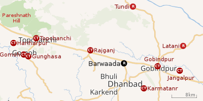 |
| Cities, towns and locations in the northern portion of Dhanbad Sadar subdivision in Dhanbad district MC: Municipal Corporation, CT: Census Town, N: Neighbourhood, R: Rural/ Urban centre Owing to space constraints in the small map, the actual locations in a larger map may vary slightly |
Location
Barwaada is located at 23.8457°N 86.4274°E.
Barwaada has not been identified as a separate place in 2011 census. As per map of Govindpur CD Block on page 121 in District Census Handbook, Dhanbad it appears to be a part of Damkarabarwa mouza.
Dhanbad Airport is located in Barwaada.[1]
Note: The map alongside presents some of the notable locations in the area. All places marked in the map are linked in the larger full screen map.
Overview
The region shown in the map lies to the north of Dhanbad city and is an extensive rural area with villages (particularly in the northern areas) scattered around hills. One of the many spurs of Pareshnath Hill (1,365.50 m), situated in neighbouring Giridih district, passes through the Topchanchi and Tundi areas of the district. The Barakar River flows along the northern boundary. The region shown in the map covers several CD blocks – Topchanchi, Govindpur, Tundi, Purbi Tundi and a small part of Baghmara. The Kolkata-Agra National Highway 19 (old number NH 2)/ Grand Trunk Road cuts across the southern part of the region.[2]
Transport
Barwaada Bypass Road links Barwaada to National Highway 19 (old number NH 2)/ Grand Trunk Road. [1]
References
- Google maps
- "District Census Handbook Dhanbad" (PDF). Series 21, Part XIIA, pages 4-5, 5-6, 8. Directorate of Census Operations, Jharkhand. Retrieved 4 June 2019.
- "Jharkhand Police". Contact Numbers. JP. Retrieved 17 June 2019.
- "Dhanbad – Welcome to the Coal Capital of India". Administrative Structure of Dhanbad District – List of Thana and Outpost of Dhanbad Outpost. Jharkhand Government. Archived from the original on 24 October 2017. Retrieved 17 June 2019.