Langdon Place, Kentucky
Langdon Place is a home rule-class city in Jefferson County, Kentucky, United States. The population was 936 as of the 2010 census.[3]
Langdon Place, Kentucky | |
|---|---|
City | |
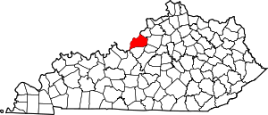
 Location of Langdon Place in Jefferson County, Kentucky | |
 Langdon Place Location within the state of Kentucky  Langdon Place Langdon Place (the United States) | |
| Coordinates: 38°17′7″N 85°35′4″W | |
| Country | United States |
| State | Kentucky |
| County | Jefferson |
| Incorporated | 1977 |
| Area | |
| • Total | 0.19 sq mi (0.48 km2) |
| • Land | 0.19 sq mi (0.48 km2) |
| • Water | 0.0 sq mi (0.0 km2) |
| Elevation | 666 ft (203 m) |
| Population (2010) | |
| • Total | 936 |
| • Estimate (2018)[2] | 982 |
| • Density | 5,098/sq mi (1,968.5/km2) |
| Time zone | UTC-5 (Eastern (EST)) |
| • Summer (DST) | UTC-4 (EDT) |
| ZIP Code | 40242 |
| FIPS code | 21-43900 |
| GNIS feature ID | 1669509 |
| Website | www |
Geography
Langdon Place is located in northeastern Jefferson County at 38°17′7″N 85°35′4″W (38.285246, -85.584417).[4] It is bordered to the north by Murray Hill, at its eastern corner by Meadow Vale, to the southeast by Rolling Hills, to the south by Westwood, to the southwest by Plantation, and otherwise by consolidated Louisville/Jefferson County.
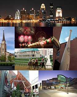
Westport Road forms the southern boundary of the city, and Goose Creek Road forms the northeast boundary. Downtown Louisville is 11 miles (18 km) to the west.
According to the United States Census Bureau, the city has a total area of 0.19 square miles (0.48 km2), of which 0.05 acres (195 m2), or 0.04%, are water.[3]
Demographics
| Historical population | |||
|---|---|---|---|
| Census | Pop. | %± | |
| 1980 | 407 | — | |
| 1990 | 874 | 114.7% | |
| 2000 | 974 | 11.4% | |
| 2010 | 936 | −3.9% | |
| Est. 2018 | 982 | [2] | 4.9% |
| U.S. Decennial Census[5] | |||
As of the census[6] of 2000, there were 974 people, 350 households, and 277 families residing in the city. The population density was 5,568.3 people per square mile (2,212.1/km²). There were 358 housing units at an average density of 2,046.7 per square mile (813.1/km²). The racial makeup of the city was 84.70% White, 8.21% African American, 0.31% Native American, 4.62% Asian, and 2.16% from two or more races. Hispanic or Latino of any race were 1.13% of the population.
There were 350 households out of which 42.9% had children under the age of 18 living with them, 68.6% were married couples living together, 7.1% had a female householder with no husband present, and 20.6% were non-families. 16.9% of all households were made up of individuals and 2.3% had someone living alone who was 65 years of age or older. The average household size was 2.78 and the average family size was 3.17.
In the city, the population was spread out with 28.1% under the age of 18, 7.7% from 18 to 24, 27.1% from 25 to 44, 30.3% from 45 to 64, and 6.8% who were 65 years of age or older. The median age was 38 years. For every 100 females, there were 94.4 males. For every 100 females age 18 and over, there were 99.4 males.
The median income for a household in the city was $67,167, and the median income for a family was $72,813. Males had a median income of $54,861 versus $32,434 for females. The per capita income for the city was $29,231. None of the families and 0.8% of the population were living below the poverty line, including no under eighteens and 3.3% of those over 64.
References
- "2016 U.S. Gazetteer Files". United States Census Bureau. Retrieved June 6, 2018.
- "Population and Housing Unit Estimates". Retrieved February 23, 2020.
- "Geographic Identifiers: 2010 Census Summary File 1 (G001): Langdon Place city, Kentucky". American Factfinder. U.S. Census Bureau. Archived from the original on February 13, 2020. Retrieved June 6, 2018.
- "US Gazetteer files: 2010, 2000, and 1990". United States Census Bureau. 2011-02-12. Retrieved 2011-04-23.
- "Census of Population and Housing". Census.gov. Retrieved June 4, 2015.
- "U.S. Census website". United States Census Bureau. Retrieved 2008-01-31.
External links
City of Louisville and metro area | ||
|---|---|---|
| History |
|  |
| Geography |
| |
| Government |
| |
| Transportation | ||
| Other subject areas | ||
| Top subjects | ||
| National Historic Landmarks | ||
| Prominent suburbs (over 10K pop.) | ||
| ||