Lanet
Lanet is a commune in the Aude department in south-western France.
Lanet | |
|---|---|
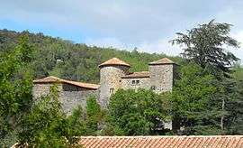 The chateau in Lanet | |
.svg.png) Coat of arms | |
Location of Lanet 
| |
 Lanet  Lanet | |
| Coordinates: 42°57′50″N 2°29′46″E | |
| Country | France |
| Region | Occitanie |
| Department | Aude |
| Arrondissement | Narbonne |
| Canton | Les Corbières |
| Intercommunality | Massif de Mouthoumet |
| Government | |
| • Mayor (2008–2014) | Jean-Marie Galinie |
| Area 1 | 8.75 km2 (3.38 sq mi) |
| Population (2017-01-01)[1] | 50 |
| • Density | 5.7/km2 (15/sq mi) |
| Time zone | UTC+01:00 (CET) |
| • Summer (DST) | UTC+02:00 (CEST) |
| INSEE/Postal code | 11187 /11330 |
| Elevation | 300–723 m (984–2,372 ft) (avg. 350 m or 1,150 ft) |
| 1 French Land Register data, which excludes lakes, ponds, glaciers > 1 km2 (0.386 sq mi or 247 acres) and river estuaries. | |
Geography
The commune is located in the Corbières Massif.
The village lies in the middle of the commune, on the right bank of the Orbieu, which flows northwest through the commune.
Population
| Historical population | ||
|---|---|---|
| Year | Pop. | ±% |
| 1962 | 39 | — |
| 1968 | 68 | +74.4% |
| 1975 | 47 | −30.9% |
| 1982 | 46 | −2.1% |
| 1990 | 57 | +23.9% |
| 1999 | 58 | +1.8% |
| 2008 | 45 | −22.4% |
See also
References
- "Populations légales 2017". INSEE. Retrieved 6 January 2020.
| Wikimedia Commons has media related to Lanet. |
| Authority control |
|
|---|
This article is issued from Wikipedia. The text is licensed under Creative Commons - Attribution - Sharealike. Additional terms may apply for the media files.