Lake Manchar
Lake Manchar (Sindhi: منڇر ڍنڍ , Urdu: منچھر جھیل), also spelled Manchhar,[1] is the largest natural freshwater lake in Pakistan,[2] and is one of Asia's largest.[3] It is located west of the Indus River, in Jamshoro District and Dadu District, Sindh - 18 km away from Sehwan Sharif.[4] Lake Manchar collects water from numerous small streams in the Kirthar Mountains, and then empties into the Indus River.[5] The lake's surface area fluctuates with the seasons - from as little as 36 km²,[6] to as much as 500 km² during monsoon rains.[6][7]
| Manchar | |
|---|---|
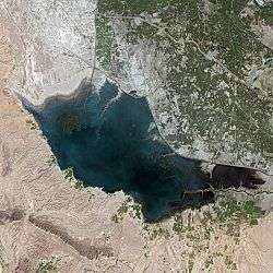 | |
| Location | Lake Manchar is located at a distance of 18 kilometers from Sehwan Sharif on west side of the River Indus, in district Jamshoro. |
| Coordinates | 26.423°N 67.673°E |
| Lake type | reservoir |
| Part of | Indus River basin |
| Primary inflows | Aral Wah Canal, Danister Canal, Nai Gaj |
| Primary outflows | Indus River |
| Basin countries | Pakistan |
| Max. length | 23.5 km (14.6 mi) |
| Max. width | 12.08 km (7.51 mi) |
| Surface area | 228 to 250 km2 (88 to 97 sq mi) |
| Max. depth | 5 m (16 ft) |
| Water volume | 600,000 acre feet (740,000,000 m3) |
| Surface elevation | 35 metres (115 ft) |
| Islands | various islands and islets |

History
The lake's banks and vicinity are home to ancient archaeological sites Ghazi Shah, Wahi Pandhi Ali Murad Mound.[8] The sites of Lal Chatto, Mashak Lohri and Lakhiyo situated along the edge of Lake Manchar are the most ancient sites,[9][10] which date from the Harappan Culture.[11]
The lake was formed when a branch of the Indus River flowed from Kashmore.[9] In 1921, it was connected to Hamal Lake via the Main Nara Valley Drain.[12] In 1958, the lake completely evaporated due to drought.[13] Between 10 August and 23 August 2009, 700 cu ft/s (20 m3/s) of water was introduced in the lake via Indus River.[14] In the 2010 Pakistan floods, the lake overflowed due to a high inflow of water.[15]
Geography
Lake Manchar is directly south of Hamal Lake, and the two are connected by the Main Nara Valley Drain built in 1921.[12] Manchar lake's surface area fluctuates with the seasons - from as little as 200 km² to as much as 500 km² during monsoon rains. The average depth is only 2.5 to 3.75 metres.[7] It is 6 metres lower than the bed of the Indus, and sometimes catches floodwater from the river, while in winter when the river is low, water flows from the lake into the Indus.[6] Freshwater flow from canals amounts to 1.54 MAF,[13] and rainfall in the area averages only 4.46 inches annual.[13]
The southern end of the lake is at the base of the Laki Hills, a branch of the Kirthar Mountains, and water flows to the Indus via the Aral channel,[16] and Danister Canal.[17]
Environmental degradation
The lake supports thousands of fisherfolk, who depend on the freshwater fish in the lake.[18] The lake since construction of the Main Nara Valley Drain in 1921 has underwent environmental degradation with inflow of sewage.[12]
The diversion of water from the Indus and a diminished storm runoff from the Kirthar mountains have contributed to the reduction in fresh water supplies, resulting in the water becoming saline, and killing off fish. At the same time, saline drainage water from agricultural fields of Balochistan and surrounding areas flows into Lake Manchar. The lake was a stop-off on the Indus flyway for Siberian migratory birds, but recently the numbers have fallen from 25,000 birds counted in 1988 to just 2,800 bird counted in 2002, because the lake no longer provides the birds' main food, the lake fish. In the place of the birds, the lake now hosts a saline water reed.
The lake also provided large volumes of water for irrigation, but this has also been reduced and has resulted in a great reduction in the area irrigated by the lake. Right Bank Outfall Drain is being built to save lake from contamination.[19] Construction of the Nai Gaj Dam upstream from the lake will result in freshwater being discharged into the lake throughout the year, instead of seasonally, which should improve the lake's waters.[3]
Population
Lake Manchar is populated by the Mohana tribe, who are sometimes referred to as the "Boat People."[20] The lake supports thousands of fisherfolk, who depend on the freshwater fish in the lake.[18]
References
- "Manchhar Lake | lake, Pakistan". Encyclopædia Britannica. Retrieved 2020-04-20.
- "Indus River and Manchhar Lake". earthobservatory.nasa.gov. 2010-09-10. Retrieved 2020-04-20.
- "NaiGaj Dam inevitable for revival of Manchar Lake". Daily Times. 2019-08-28. Retrieved 2020-04-20.
- "Manchar Lake". Discover Pakistan. Retrieved 2018-12-11.
- "Manchar Lake - The Largest Artficial Freshwater Lake in Pakistan". Pakistantoursguide.com. Retrieved 23 July 2018.
- Goudie, Andrew (2002). Great Warm Deserts of the World: Landscapes and Evolution. Oxford University Press. ISBN 978-0-19-924515-4.
- Ebrahim, Zofeen; September 17; 2015. "Photo story: The destruction of Pakistan's Manchar lake". The Third Pole. Retrieved 2020-04-20.CS1 maint: numeric names: authors list (link)
- Ahmed, Mukhtar (2014-10-25). Ancient Pakistan - an Archaeological History: Volume III: Harappan Civilization - the Material Culture. Amazon. ISBN 9781495966439.
- Abraham, Shinu Anna; Gullapalli, Praveena; Raczek, Teresa P.; Rizvi, Uzma Z. (2016-06-16). Connections and Complexity: New Approaches to the Archaeology of South Asia. Routledge. ISBN 9781315431840.
- Majumdar, Nani Gopal (1996). Explorations in Art and Archaeology of South Asia: Essays Dedicated to N.G. Majumdar. Directorate of Archaeology and Museums, Government of West Bengal.
- Shendge, Malati J. (June 2003). The Civilized Demons: The Harappans in Rigveda. Abhinav Publications. ISBN 9788170170648.
- Ilyas, Faiza (2012-03-15). "Release of minimum 10MAF water downstream Kotri urged". Dawn. Pakistan. Retrieved 2020-04-20.
- Zehra, Syeda Mahe (May 2010). Time series models of the electrical conductivity measured at the Manchar Lake in Pakistan (thesis thesis).
- http://www.akhbar-e-jehan.com/home/text/317hydrabad.gif%5B%5D Baluchistan and Punjab Poisoning the Manchar Lake
- "Six weeks on, south Pakistan faces new flood threat". Reuters. 2010-09-13. Retrieved 2020-04-20.
- Pruthi, R. K. (2004). Indus Civilization. Discovery Publishing House. ISBN 978-81-7141-865-7.
- "DADU: Manchhar lake to get water from Indus". Dawn. Pakistan. 2006-06-26. Retrieved 2020-04-20.
- "Rebuilding life on Manchar Lake in Pakistan". Caritas. 2011-07-26. Retrieved 2020-04-20.
- "PC-I for Right Bank Outfall Drain rejected".
- "PROJECT APPRAISAL DOCUMENT ON A PROPOSED CREDIT IN THE AMOUNT OF 100.1 SDR MILLION (US$150.2 MILLION EQUIVALENT) TO THE ISLAMIC REPUBLIC OF PAKISTAN FOR A SINDH WATER SECTOR IMPROVEMENT PHASE-I PROJECT" (PDF). World Bank. 2007.
External links
- Zofeen Ebrahim. "Life on Lake Turns from Sweet to Bitter". Asia Water Wire. Archived from the original on 2010-01-03. Retrieved 2009-06-14.