La Châtre
La Châtre (French pronunciation: [la ʃɑtʁ]) is a commune in the Indre department in central France.
La Châtre | |
|---|---|
Subprefecture and commune | |
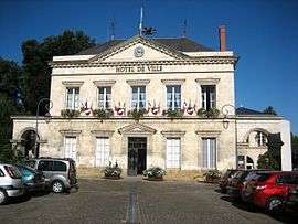 Town hall | |
.svg.png) Coat of arms | |
Location of La Châtre 
| |
 La Châtre  La Châtre | |
| Coordinates: 46°34′59″N 1°59′16″E | |
| Country | France |
| Region | Centre-Val de Loire |
| Department | Indre |
| Arrondissement | La Châtre |
| Canton | La Châtre |
| Government | |
| • Mayor (2008–2014) | Nicolas Forissier |
| Area 1 | 6.06 km2 (2.34 sq mi) |
| Population (2017-01-01)[1] | 4,109 |
| • Density | 680/km2 (1,800/sq mi) |
| Time zone | UTC+01:00 (CET) |
| • Summer (DST) | UTC+02:00 (CEST) |
| INSEE/Postal code | 36046 /36400 |
| Elevation | 198–263 m (650–863 ft) (avg. 222 m or 728 ft) |
| 1 French Land Register data, which excludes lakes, ponds, glaciers > 1 km2 (0.386 sq mi or 247 acres) and river estuaries. | |
Population
| Historical population | ||
|---|---|---|
| Year | Pop. | ±% |
| 1793 | 4,000 | — |
| 1800 | 3,357 | −16.1% |
| 1806 | 3,926 | +16.9% |
| 1821 | 4,049 | +3.1% |
| 1831 | 4,343 | +7.3% |
| 1836 | 4,471 | +2.9% |
| 1841 | 4,635 | +3.7% |
| 1846 | 4,910 | +5.9% |
| 1851 | 4,970 | +1.2% |
| 1856 | 4,981 | +0.2% |
| 1861 | 5,038 | +1.1% |
| 1866 | 5,167 | +2.6% |
| 1872 | 4,928 | −4.6% |
| 1876 | 4,993 | +1.3% |
| 1881 | 5,234 | +4.8% |
| 1886 | 5,215 | −0.4% |
| 1891 | 5,048 | −3.2% |
| 1896 | 4,850 | −3.9% |
| 1901 | 4,737 | −2.3% |
| 1906 | 4,744 | +0.1% |
| 1911 | 4,770 | +0.5% |
| 1921 | 3,931 | −17.6% |
| 1926 | 3,880 | −1.3% |
| 1931 | 3,734 | −3.8% |
| 1936 | 3,779 | +1.2% |
| 1946 | 4,109 | +8.7% |
| 1954 | 4,110 | +0.0% |
| 1962 | 4,025 | −2.1% |
| 1968 | 4,524 | +12.4% |
| 1975 | 4,847 | +7.1% |
| 1982 | 4,922 | +1.5% |
| 1990 | 4,623 | −6.1% |
| 1999 | 4,548 | −1.6% |
| 2008 | 4,477 | −1.6% |
Personalities
- It was the birthplace of Henri de Latouche and Emile Acollas. André Boillot the auto racing driver crashed here in 1932 and died from his injuries.
- George Sand lived for most of her life at Nohant-Vic near La Châtre.
From 1938 to his death in 1953, Jean de Boschère lived in La Châtre with his companion Elizabeth d'Ennetières.
References
- "Populations légales 2017". INSEE. Retrieved 6 January 2020.
| Wikimedia Commons has media related to La Châtre. |
| Authority control |
|
|---|
This article is issued from Wikipedia. The text is licensed under Creative Commons - Attribution - Sharealike. Additional terms may apply for the media files.