Kviteseid
Kviteseid is a municipality in Telemark in the county of Vestfold og Telemark in Norway. It is part of the traditional region of Upper Telemark and Vest-Telemark. The administrative centre of the municipality is the village of Kviteseid. The parish of Hvideseid was established as a municipality on 1 January 1838 (see formannskapsdistrikt). Kviteseid Seminar was the first public school which started in 1819 and was in operation until 1889. Kviteseid Library (Kviteseid Folkebibliotek) was founded in 1895. The library was first based on a book collection from Kviteseid Seminar.[3]
Kviteseid kommune | |
|---|---|
 | |
 Coat of arms  Vestfold og Telemark within Norway | |
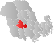 Kviteseid within Vestfold og Telemark | |
| Coordinates: 59°23′54″N 8°29′42″E | |
| Country | Norway |
| County | Vestfold og Telemark |
| District | Vest-Telemark |
| Administrative centre | Kviteseid |
| Government | |
| • Mayor (2015) | Tarjei Gjelstad (Ap) |
| Area | |
| • Total | 708 km2 (273 sq mi) |
| • Land | 624 km2 (241 sq mi) |
| Area rank | 157 in Norway |
| Population (2004) | |
| • Total | 2,622 |
| • Rank | 296 in Norway |
| • Density | 4/km2 (10/sq mi) |
| • Change (10 years) | -6.9% |
| Demonym(s) | Kvitseiding[1] |
| Time zone | UTC+01:00 (CET) |
| • Summer (DST) | UTC+02:00 (CEST) |
| ISO 3166 code | NO-3821 |
| Official language form | Nynorsk[2] |
| Website | www |
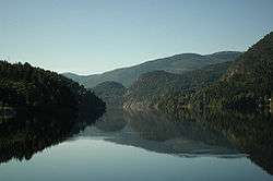
The main industries of the municipality are forestry, agriculture, tourism, and hydroelectric power. The Telemark Canal goes through Kviteseid. There are also several ski resorts in Kviteseid. Vrådal is one of them.
Within the municipality of Kviteseid, one finds the little village of Morgedal, also known as the "Cradle of Modern Skiing" ("Skisportens vugge") and home of Sondre Norheim. Here, the Olympic Flame was lit for the 1952 Winter Olympics in Oslo, 1960 Winter Olympics in Squaw Valley, and 1994 Winter Olympics in Lillehammer.
General information
Name
The Old Norse form of the name was Hvítiseið. The first element is the genitive case of Hvítir which means "the white one" (probably an older name of Kviteseidvatn) and the last element is eið which means "path between two lakes". Prior to 1889, the name was written "Hviteseid".[4]
Coat-of-arms
The coat-of-arms is from modern times. They were granted in 1987. The arms show an old black-colored lock on a gold/yellow background. It was chosen to symbolize safety.
Geography
The municipality borders Seljord to the northwest; Nome to the east; Drangedal, Nissedal, and Fyresdal to the south; and Tokke to the west. The highest point is Sveinsheia at 1,141 metres (3,743 ft) above sea level. The small parish of Åsgrend is within the boundaries of Kviteseid.
References
- "Navn på steder og personer: Innbyggjarnamn" (in Norwegian). Språkrådet.
- "Forskrift om målvedtak i kommunar og fylkeskommunar" (in Norwegian). Lovdata.no.
- "Kviteseid Seminar". lokalhistoriewiki.no. Retrieved March 1, 2018.
- Rygh, Oluf (1914). Norske gaardnavne: Bratsbergs amt (Dokumentasjonsprosjektet) (in Norwegian) (7 ed.). Kristiania, Norge: W. C. Fabritius & sønners bogtrikkeri. pp. 348–349.
External links


- Municipal fact sheet from Statistics Norway

- Fjaagesund.no
Vestfold og Telemark county, Norway | |||||||||||||||||||||||||||
|---|---|---|---|---|---|---|---|---|---|---|---|---|---|---|---|---|---|---|---|---|---|---|---|---|---|---|---|
 |
|  | |||||||||||||||||||||||||
||