Bamble
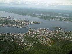
Bamble is a municipality in Vestfold og Telemark county, Norway. It is part of the traditional region of Grenland. The administrative centre of the municipality is the village of Langesund.
Bamble kommune Bamble | |
|---|---|
| Bamble | |
 | |
 Coat of arms  Vestfold og Telemark within Norway | |
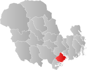 Bamble within Vestfold og Telemark | |
| Coordinates: 59°1′11″N 9°33′39″E | |
| Country | Norway |
| County | Vestfold og Telemark |
| District | Grenland |
| Administrative centre | Langesund |
| Government | |
| • Mayor (2015) | Hallgeir Kjeldal (Labour) |
| Area | |
| • Total | 304 km2 (117 sq mi) |
| • Land | 282 km2 (109 sq mi) |
| Area rank | 274 in Norway |
| Population (2004) | |
| • Total | 14,163 |
| • Rank | 70 in Norway |
| • Density | 50/km2 (100/sq mi) |
| • Change (10 years) | 0.6% |
| Demonyms | Bambling or Bamling Bemling (archaic)[1] |
| Time zone | UTC+01:00 (CET) |
| • Summer (DST) | UTC+02:00 (CEST) |
| ISO 3166 code | NO-3813 |
| Official language form | Neutral[2] |
| Website | www |
General information
Name
The Old Norse form of the name was Bamblar (a plural form). The name could be related to the word bembel m 'belly' (used in the meaning 'round hill/mountain'). The name was written "Bamle" in the period 1889–1917.[3]
See also the name Bømlo.
Coat-of-arms
The coat-of-arms is from modern times. They were granted on 12 December 1986. The arms show a gold-colored ship's wheel on a blue background. The arms are nearly identical to the former arms of Stathelle, which along with Langesund was merged with the municipality of Bamble on 1 January 1964. Sailing and fishing have always been of great importance for the area, and a ship's wheel was thus an appropriate symbol.[4][5]
History
The municipality of Bamble was established on 1 January 1838 (see formannskapsdistrikt). The lading place of Stathelle was separated from the municipality of Bamble in 1851. On 1 January 1964, the municipality of Bamble was merged with the neighboring municipalities of Stathelle and Langesund. The new municipality was named Bamble, the administrative centre was Langesund, and the coat-of-arms of Stathelle were used for the new municipality.[5]
Bamble, lying at the southern tip of the Kongsberg-Bamble geological formation, also has a unique geology that has been extensively researched by geologists such as W. C. Brøgger. It exhibits a high grade gneiss terrane characterized by metasomatism.[6] As such there have been many mines operating in the area, most notably the Ødegården Verk apatite mines and the nickel mines in Nystein.
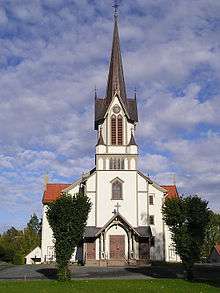
Bamble Church (Bamble kirke) is located at E18 south of Grenland Bridge. It is a wooden cruciform church which was built in 1845. The church is located next to the ruins of Olav Church which dated to around 1145.[7][8]
International relations
Twin towns — Sister cities
The following cities are twinned with Bamble:[9]


References
- "Navn på steder og personer: Innbyggjarnamn" (in Norwegian). Språkrådet.
- "Forskrift om målvedtak i kommunar og fylkeskommunar" (in Norwegian). Lovdata.no.
- Rygh, Oluf (1914). Norske gaardnavne: Bratsbergs amt (in Norwegian) (7 ed.). Kristiania, Norge: W. C. Fabritius & sønners bogtrikkeri. pp. 48–49.
- Norske Kommunevåpen (1990). "Nye kommunevåbener i Norden". Retrieved 2009-01-15.
- "Kommunens våpenskjold". Bamble kommune. Retrieved 2009-01-15. (in Norwegian)
- Nijland, T.G.; Zwaan, J.C.; Touret, L. (Dec 1998). "Topographical mineralogy of the Bamble sector, south Norway". Scripta Geologica. Naturalis. 118: 1–46. Retrieved 18 January 2013.
- "Bamble kirke". lokalhistoriewiki.no. Retrieved September 1, 2016.
- "Olavskirken – Skeidi kirke i Bamble". miklaborg.net. Archived from the original on 2016-09-20. Retrieved September 1, 2016.
- "Vennskapsbyer" (in Norwegian). Bamble kommune. Archived from the original on 5 December 2008. Retrieved 2009-01-15.
External links


- Municipal fact sheet from Statistics Norway

Vestfold og Telemark county, Norway | |||||||||||||||||||||||||||
|---|---|---|---|---|---|---|---|---|---|---|---|---|---|---|---|---|---|---|---|---|---|---|---|---|---|---|---|
 |
|  | |||||||||||||||||||||||||
||