Kottathara
Kottathara or Venniyode is a gram panchayat of Wayanad district, Kerala State, India.[1]
Kottathara | |
|---|---|
village | |
 Paradhevatha Kavu, Venniyode | |
| Coordinates: 11.65636°N 76.02496°E | |
| Country | |
| State | Kerala |
| District | Wayanad |
| Languages | |
| • Official | Malayalam, English |
| Time zone | UTC+5:30 (IST) |
| PIN | 673122 |
| ISO 3166 code | IN-KL |
Location
Kottathara is located near Kambalakkad town on Kalpetta - Mananthavady route.Venniyode is a small township which is located on the link road between Kamblakkad and Padinharathara.Valal is the nearest village from Venniode junction.
Administration
Even though Kottathara is a small town, it has its own administrative structure called a panchayath to It is under LSGD Govt. of Kerala. The headquarters of the Panchayath is located at Venniyod town.
Venniyode Junction
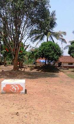
Venniyode Junction is the headquaraters of Kottathara village.[2] There are a few village teashops, schools and temples in this village center. The sacred grove called Paradhevatha Kavu is well maintained and attracts many visitors. This is a sacred grove with many holy stones painted white and a little cute vishnu temple attached t it. There is also one Jain temple here.
Transportation
Kottathara can be accessed from Mananthavady or Kalpetta. The Periya ghat road connects Mananthavady to Kannur and Thalassery. The Thamarassery mountain road connects Calicut with Kalpetta. The Kuttiady mountain road connects Vatakara with Kalpetta and Mananthavady. The Palchuram mountain road connects Kannur and Iritty with Mananthavady. The road from Nilambur to Ooty is also connected to Wayanad through the village of Meppadi.
The nearest railway station is at Mysore and the nearest airports are Kozhikode International Airport-120 km, Bengaluru International Airport-290 km, and Kannur International Airport, 58 km.
Location
Location of Kottathara Panchayath | ||||||||||
|---|---|---|---|---|---|---|---|---|---|---|
| ||||||||||
Gallery
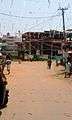 Venniyode Junction
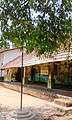 The old school at Venniyode
References