Komsomolsk-on-Amur
Komsomolsk-on-Amur (Russian: Комсомольск-на-Амуре, tr. Komsomolsk-na-Amure, IPA: [kəmsɐˈmolʲsk nɐɐˈmurʲə]) is a city in Khabarovsk Krai, Russia, located on the left bank of the Amur River in the Russian Far East. It is located on the Baikal-Amur Mainline, 356 kilometers (221 mi) northeast of Khabarovsk. As of 2010, it had a population of 263,906 (2010 Census);[3] 281,035 (2002 Census);[11] 315,325 (1989 Census).[12]
Komsomolsk-on-Amur Комсомольск-на-Амуре | |
|---|---|
City[1] | |
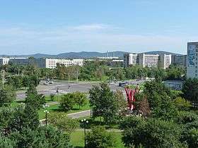 View of Komsomolsk-on-Amur | |
.png) Flag _(1999).png) Coat of arms | |
Location of Komsomolsk-on-Amur 
| |
 Komsomolsk-on-Amur Location of Komsomolsk-on-Amur 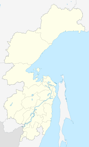 Komsomolsk-on-Amur Komsomolsk-on-Amur (Khabarovsk Krai) | |
| Coordinates: 50°34′N 137°00′E | |
| Country | Russia |
| Federal subject | Khabarovsk Krai[1] |
| Founded | 1932 |
| City status since | 1933 |
| Government | |
| • Head | Alexander Viktorovich Zhornik |
| Area | |
| • Total | 325.10 km2 (125.52 sq mi) |
| Elevation | 47 m (154 ft) |
| Population | |
| • Total | 263,906 |
| • Estimate (2018)[4] | 248,254 (-5.9%) |
| • Rank | 70th in 2010 |
| • Density | 810/km2 (2,100/sq mi) |
| • Subordinated to | city of krai significance of Komsomolsk-na-Amure[1] |
| • Capital of | city of krai significance of Komsomolsk-na-Amure[5], Komsomolsky District[6] |
| • Urban okrug | Komsomolsk-na-Amure Urban Okrug[7] |
| • Capital of | Komsomolsk-na-Amure Urban Okrug[7], Komsomolsky Municipal District[8] |
| Time zone | UTC+10 (MSK+7 |
| Postal code(s)[10] | 6810xx |
| Dialing code(s) | +7 4217 |
| OKTMO ID | 08709000001 |
| Twin towns | Jiamusi, Kamo |
| Website | www |
Geography
The city and its suburbs stretch for over 30 kilometers (19 mi) along the left bank of the Amur River. The river at this point is up to 2.5 kilometers (1.6 mi) wide.
The distance to Khabarovsk—the administrative center of the krai—is 356 kilometers (221 mi); to the Pacific Ocean—about 300 kilometers (190 mi). The nearest other major town is Amursk, about 45 kilometers (28 mi) south.
It is about 3,900 miles (6,300 km) east of Moscow, and lies at the eastern end of the BAM Railway.
History
The future site of Komsomolsk-on-Amur was conquered by Mongols in the 13th century, becoming part of Mongol Empire under the Mongol Yuan Dynasty and later Manchus held until 1858 treaty of Aigun ceded the area to the Russian Empire.
The village of Permskoye (Пе́рмское) was established on the later site of Komsomolsk in 1860 by migrant peasants from what is now Perm Krai.
The government of the Russian SFSR announced in 1931 plans to construct a shipyard on the Amur at the present site of Komsomolsk, with construction beginning in 1932. The town was largely built using volunteer labor from the Communist youth organization Komsomol, thus receiving the name Komsomolsk. However, the construction of the town was aided with the use of penal labour from the prison camps situated in the area.[13] The suffix on Amur was added to differentiate from other towns with the same name. It was granted town status in 1933.
By the end of the 1940s, the shipyards along with facilities for other heavy industry had been completed. The city developed into a regional center for industries such as aircraft manufacturing, metallurgy, machinery, oil refining, and shipbuilding. At present, Komsomolsk-on-Amur is the main center for the manufacture of Sukhoi military aircraft and the Sukhoi Superjet airliner.[14] The MiG-15bis [15] and the Lisunov Li-2[16] were both manufactured in Komsomolsk-on-Amur.
Administrative and municipal status
Within the framework of administrative divisions, Komsomolsk-on-Amur serves as the administrative center of Komsomolsky District,[6] even though it is not a part of it.[1] As an administrative division, it is incorporated separately as the city of krai significance of Komsomolsk-na-Amure—an administrative unit with the status equal to that of the districts.[1] As a municipal division, the city of krai significance of Komsomolsk-na-Amure is incorporated as Komsomolsk-na-Amure Urban Okrug.[7] The city is administratively divided into 2 okrugs (previously raion), coinciding with the historical parts: Leninsky (Dzemgi) and Central.
In the Soviet period, the administrative-territorial division of the city was different from the present. In accordance with the Decree of the Presidium of the Supreme Soviet of the RSFSR of 19 October 1943 were formed Lenin, Stalin and Central areas. Stalinsky district included the territory of Railway Amurstali and residential community.
Presidium of the Supreme Soviet of the RSFSR "On the Abolition of the city of Komsomolsk-on-Amur, Khabarovsk Krai" on August 7, 1957 in the district division was abolished, but the decree of March 31, 1972 the Presidium of the Supreme Soviet of the newly divided the city into two districts - Central and Leninsky.
Layout

Komsomolsk-on-Amur consists of two historical parts: the center, or "city", where the main enterprise - Shipyard, and the Dzemgi - an area that has formed during the construction of an aircraft factory (future KnAAPO). In fact, each of the parts is a separate town, itself a single center in the city.
Areas of the city are very different architectural appearance: Center Stalinist buildings dominated the 40-50s (exception - the residential area near the railway station), Dzemgi is built up mainly typical panel apartment blocks. The "sleeping" area Dzemgi is not, as the majority of their residents work in enterprises located here.
Climate
Komsomolsk-on-Amur has a humid continental climate (Köppen Dfb). Temperatures in the area of the city typically change by over 56 °C (100.8 °F) over the course of the year, with a daily average of −24.7 °C (−12.5 °F) in January, compared to +20.3 °C (68.5 °F) in July.
| Climate data for Komsomolsk-on-Amur | |||||||||||||
|---|---|---|---|---|---|---|---|---|---|---|---|---|---|
| Month | Jan | Feb | Mar | Apr | May | Jun | Jul | Aug | Sep | Oct | Nov | Dec | Year |
| Record high °C (°F) | 0.7 (33.3) |
0.0 (32.0) |
13.6 (56.5) |
23.9 (75.0) |
31.0 (87.8) |
33.2 (91.8) |
36.2 (97.2) |
38.0 (100.4) |
30.0 (86.0) |
20.5 (68.9) |
8.3 (46.9) |
1.0 (33.8) |
38.0 (100.4) |
| Average high °C (°F) | −19.6 (−3.3) |
−13.9 (7.0) |
−4.0 (24.8) |
7.5 (45.5) |
16.1 (61.0) |
22.8 (73.0) |
25.1 (77.2) |
23.4 (74.1) |
17.1 (62.8) |
7.4 (45.3) |
−6.4 (20.5) |
−17.2 (1.0) |
4.6 (40.3) |
| Daily mean °C (°F) | −24.7 (−12.5) |
−19.8 (−3.6) |
−9.5 (14.9) |
2.3 (36.1) |
10.4 (50.7) |
17.3 (63.1) |
20.3 (68.5) |
18.5 (65.3) |
11.9 (53.4) |
2.5 (36.5) |
−10.5 (13.1) |
−21.8 (−7.2) |
−0.6 (30.9) |
| Average low °C (°F) | −30.8 (−23.4) |
−27.2 (−17.0) |
−17.1 (1.2) |
−3.4 (25.9) |
3.7 (38.7) |
10.8 (51.4) |
15.2 (59.4) |
13.5 (56.3) |
6.4 (43.5) |
−2.9 (26.8) |
−16.1 (3.0) |
−27.4 (−17.3) |
−6.6 (20.1) |
| Record low °C (°F) | −47.0 (−52.6) |
−42.0 (−43.6) |
−33.9 (−29.0) |
−20.8 (−5.4) |
−7.5 (18.5) |
−2.2 (28.0) |
0.0 (32.0) |
−8.9 (16.0) |
−6.0 (21.2) |
−22.0 (−7.6) |
−34.0 (−29.2) |
−42.0 (−43.6) |
−47.0 (−52.6) |
| Average precipitation mm (inches) | 30 (1.2) |
19 (0.7) |
30 (1.2) |
43 (1.7) |
63 (2.5) |
65 (2.6) |
95 (3.7) |
110 (4.3) |
74 (2.9) |
62 (2.4) |
49 (1.9) |
32 (1.3) |
669 (26.3) |
| Average precipitation days | 14 | 12 | 13 | 15 | 15 | 13 | 15 | 14 | 14 | 13 | 16 | 15 | 169 |
| Average rainy days | 0 | 0 | 1 | 7 | 14 | 13 | 15 | 14 | 14 | 8 | 1 | 0 | 87 |
| Average snowy days | 14 | 12 | 13 | 11 | 3 | 0 | 0 | 0 | 0 | 8 | 15 | 15 | 91 |
| Source 1: climatebase.ru[17] | |||||||||||||
| Source 2: Weatherbase[18] | |||||||||||||
Economy and infrastructure
Komsomolsk-on-Amur is an important industrial center of Khabarovsk Krai and of the Russian Far East.[19] It has a diversified economy where machine building, metallurgy and timber enterprises dominate.[20]
The city's most notable company is Komsomolsk-on-Amur Aircraft Production Association, Russia's largest aircraft-manufacturing enterprise. It is among Khabarovsk Krai's most successful enterprises, and for years has been the largest taxpayer of the territory.[21] It has manufactured hundreds of civil aircraft and thousands of various-role military aircraft from the first recon aircraft to modern Su- series fighters and light amphibian aeroplanes.[22] The company is hugely important to the city's economy, contributing 45% of all payments into the local budget.[21]
Also based in the city is Amur Shipbuilding Plant, an important producer of ships and submarines.[23]
The eastern-most GLONASS telemetry and tracking station is located in Komsomolsk-on-Amur.
Two air bases are located near the city, Khurba to the south and Dzemgi to the north.
Komsomolsk-on-Amur railway station is an important rail junction of Baikal-Amur Mainline and Komsomolsk-Dezhnyovka railway line.
The city is served by the Komsomolsk-on-Amur Airport
Public transport includes 5 tram routes, bus and fixed-taxi (marshrutka).
The first sortie of the Sukhoi Su-57 prototype occurred at the Gagarin Factory.[24]
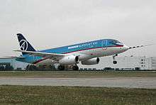 Test flight of a Sukhoi Superjet 100 prototype in Komsomolsk-on-Amur
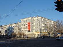
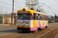 Tram
Tram
Twin towns – sister cities
Notable residents
- Alex Chubrevich, Israeli Russian professional basketball player for Maccabi Haifa of the Israeli Super League.
- Alexandra Ivanovskaya, "Miss Russia 2005"
- Ivan Shtyl, sprint canoer
- Sergei Plotnikov, Ice hockey player with Pittsburgh Penguins, NHL
- Pasha Kovalev, Professional dancer
- Yury Gazinsky, footballer, scorer of the first goal at the 2018 FIFA World Cup, was born in the city.
- Anatoly Dyatlov
- Valentina Khetagurova (1914–1992), founder of the Khetagourova
See also
References
Notes
- Resolution #143-pr
- "Результат запроса". www.gks.ru. Retrieved November 1, 2017.
- Russian Federal State Statistics Service (2011). "Всероссийская перепись населения 2010 года. Том 1" [2010 All-Russian Population Census, vol. 1]. Всероссийская перепись населения 2010 года [2010 All-Russia Population Census] (in Russian). Federal State Statistics Service.
- http://habstat.gks.ru/wps/wcm/connect/rosstat_ts/habstat/resources/4fcf3a80408ea6bca127eb4d45abe5e4/Численность+населения+Хабаровского+края+по+муниципальным+образованиям+на+1+января+2018+года.doc.
- Государственный комитет Российской Федерации по статистике. Комитет Российской Федерации по стандартизации, метрологии и сертификации. №ОК 019-95 1 января 1997 г. «Общероссийский классификатор объектов административно-территориального деления. Код 08 409», в ред. изменения №278/2015 от 1 января 2016 г.. (State Statistics Committee of the Russian Federation. Committee of the Russian Federation on Standardization, Metrology, and Certification. #OK 019-95 January 1, 1997 Russian Classification of Objects of Administrative Division (OKATO). Code 08 409, as amended by the Amendment #278/2015 of January 1, 2016. ).
- Государственный комитет Российской Федерации по статистике. Комитет Российской Федерации по стандартизации, метрологии и сертификации. №ОК 019-95 1 января 1997 г. «Общероссийский классификатор объектов административно-территориального деления. Код 08 220», в ред. изменения №278/2015 от 1 января 2016 г.. (State Statistics Committee of the Russian Federation. Committee of the Russian Federation on Standardization, Metrology, and Certification. #OK 019-95 January 1, 1997 Russian Classification of Objects of Administrative Division (OKATO). Code 08 220, as amended by the Amendment #278/2015 of January 1, 2016. ).
- Law #192
- Law #264
- "Об исчислении времени". Официальный интернет-портал правовой информации (in Russian). June 3, 2011. Retrieved January 19, 2019.
- Почта России. Информационно-вычислительный центр ОАСУ РПО. (Russian Post). Поиск объектов почтовой связи (Postal Objects Search) (in Russian)
- Russian Federal State Statistics Service (May 21, 2004). "Численность населения России, субъектов Российской Федерации в составе федеральных округов, районов, городских поселений, сельских населённых пунктов – районных центров и сельских населённых пунктов с населением 3 тысячи и более человек" [Population of Russia, Its Federal Districts, Federal Subjects, Districts, Urban Localities, Rural Localities—Administrative Centers, and Rural Localities with Population of Over 3,000] (XLS). Всероссийская перепись населения 2002 года [All-Russia Population Census of 2002] (in Russian).
- "Всесоюзная перепись населения 1989 г. Численность наличного населения союзных и автономных республик, автономных областей и округов, краёв, областей, районов, городских поселений и сёл-райцентров" [All Union Population Census of 1989: Present Population of Union and Autonomous Republics, Autonomous Oblasts and Okrugs, Krais, Oblasts, Districts, Urban Settlements, and Villages Serving as District Administrative Centers]. Всесоюзная перепись населения 1989 года [All-Union Population Census of 1989] (in Russian). Институт демографии Национального исследовательского университета: Высшая школа экономики [Institute of Demography at the National Research University: Higher School of Economics]. 1989 – via Demoscope Weekly.
- Aleksander Solzhenitsyn, The Gulag Archipelago: 1918-1956, 592-593
- "Team.Aero - Sukhoi Rolls Out Superjet 100 in Aeroflot Livery". Team.Aero. Retrieved November 1, 2017.
- "What was the yearly number of MiG-15's produced?". aviation.stackexchange.com. Retrieved November 1, 2017.
- http://www.oldwings.nl/st/li2.pdf
- "climatebase.ru (1948-2011)". Retrieved April 28, 2012.
- "Weatherbase: Historical Weather for Komsomolsk-on-Amur, Russia". Weatherbase. 2012. Retrieved on November 24, 2011.
- Komsomolsk-on-Amur city Archived August 12, 2009, at the Wayback Machine
- "Komsomolsk-on-Amur Regional Overview". Retrieved November 1, 2017.
- Pike, John. "KNAAPO Komsomolsk na Amure Aviation Industrial Association named after Gagarin - Russian". www.globalsecurity.org. Retrieved November 1, 2017.
- "Page not found". www.uacrussia.ru. Archived from the original on January 31, 2009. Retrieved November 1, 2017.
- Sputnik. "Crew member 'tampered with temperature sensor on Nerpa sub'". en.rian.ru. Retrieved November 1, 2017.
- "Sukhoi T-50 Prototype Flies For The First Time In 40 Minute Sortie". Retrieved November 1, 2017.
- "Города-побратимы". kmscity.ru (in Russian). Komsomolsk-on-Amur. Retrieved February 4, 2020.
Sources
- Правительство Хабаровского края. Постановление №143-пр от 18 июля 2007 г. «Об утверждении реестра административно-территориальных и территориальных единиц Хабаровского края», в ред. Постановления №273-пр от 28 августа 2015 г. «О внесении изменений в Постановление Правительства Хабаровского края от 18 июля 2007 г. №143-пр "Об утверждении реестра административно-территориальных и территориальных единиц Хабаровского края"». Вступил в силу 13 августа 2007 г. Опубликован: "Собрание законодательства Хабаровского края", №7(60), 12 августа 2007 г. (Government of Khabarovsk Krai. Resolution #143-pr of July 18, 2007 On the Adoption of the Registry of the Administrative-Territorial and Territorial Units of Khabarovsk Krai, as amended by the Resolution #273-pr of August 28, 2015 On Amending the Resolution #143-pr of the Government of Khabarovsk Krai of July 18, 2007 "On the Adoption of the Registry of the Administrative-Territorial and Territorial Units of Khabarovsk Krai". Effective as of August 13, 2007.).
- Законодательная Дума Хабаровского края. Закон №192 от 30 июня 2004 г. «О наделении муниципального образования города Комсомольска-на-Амуре статусом городского округа и об установлении его границы». Вступил в силу со дня официального опубликования. Опубликован: "Приамурские ведомости", №№136–137, 29 июля 2004 г. (Legislative Duma of Khabarovsk Krai. Law #192 of June 30, 2004 On Granting Urban Okrug Status to the Municipal Formation of the City of Komsomolsk-on-Amur and on Establishing Its Border. Effective as of the day of the official publication.).
- Законодательная Дума Хабаровского края. Закон №264 от 14 марта 2005 г «Об административных центрах сельских поселений и муниципальных районов Хабаровского края», в ред. Закона №239 от 28 ноября 2012 г. «О преобразовании городского населённого пункта рабочий посёлок Тырма, находящегося на территории Верхнебуреинского района Хабаровского края, путём изменения его статуса в сельский населённый пункт — посёлок Тырма и о внесении изменений в отдельные Законы Хабаровского края». Вступил в силу со дня официального опубликования. Опубликован: "Приамурские ведомости", №57, 1 апреля 2005 г. (Legislative Duma of Khabarovsk Krai. Law #264 of March 14, 2005 On the Administrative Centers of the Rural Settlements and the Municipal Districts of Khabarovsk Krai, as amended by the Law #239 of November 28, 2012 On the Transformation of the Urban Locality the Work Settlement of Tyrma, Located on the Territory of Verkhnebureinsky District of Khabarovsk Krai, by Changing Its Status to That of a Rural Locality—the Settlement of Tyrma, and on Amending Various Laws of Khabarovsk Krai. Effective as of the day of the official publication.).
External links
| Wikivoyage has a travel guide for Komsomolsk-on-Amur. |
| Wikimedia Commons has media related to Komsomolsk-on-Amur. |
- Komsomolsk-na-Amure at the Encyclopædia Britannica
- Sports in Komsomolsk-on-Amur
- FC Smena (Komsomolsk-on-Amur)
| Districts | ||
|---|---|---|
| Cities and towns | ||
| Urban-type settlements | ||