Koewarasan
Koewarasan is a resort in Suriname, located in the Wanica District. Its population at the 2012 census was 27,713.[1]. It is located to the west of Paramaribo, and is mainly a suburban area. The municipality was founded in 1939, and was originally intended for settlers from Java, however due to World War II, only a single group arrived.[2] The majority of the population are East Indian.[1] Prior to 1939, Koewarasan was an agricultural area used for the cultivation of rice.[3]
Koewarasan | |
|---|---|
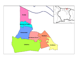 Map showing the resorts of Wanica District.
Koewarasan | |
| Country | |
| District | Wanica District |
| Area | |
| • Total | 71 km2 (27 sq mi) |
| Population (2012)[1] | |
| • Total | 27,713 |
| • Density | 390/km2 (1,000/sq mi) |
| Time zone | UTC-3 (AST) |
Sunny Point
The Surinamese Interior War caused the population of Pokigron to flee. A large group of civilians squatted[4][5] a terrain on Koewarasan, and have named their village, Sunny Point.[5] A school has been setup by the organisation Kansrijk Suriname, and on 24 March 2018, a library opened.[5] On 3 January 2019, 60 families living in Sunny Point-3 faced eviction.[6]
References
- "Resorts in Suriname Census 2012" (PDF). Retrieved 12 May 2020.
- "Geschiedenis". Wanica.nl (in Dutch). Retrieved 20 May 2020.
- "Concurrentie in de landbouw". Dagblad Suriname (in Dutch). Retrieved 20 May 2020.
- "De ondergang van een Surinaams bosnegerdorp". Terdege via Delpher (in Dutch). 2 January 1991. Retrieved 20 May 2020.
- "Wat wij doen in Sunny Point". Kansrijk Suriname (in Dutch). Retrieved 20 May 2020.
- "Dc Ramai belooft spoedige oplossing voor krakers Sunny Point-3". Suriname Herald (in Dutch). Retrieved 20 May 2020.