Route F35 (Iceland)
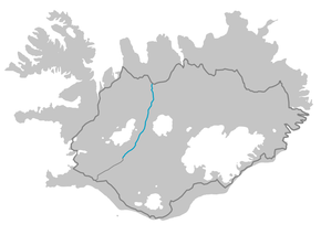
Kjalvegur is a highland road in Iceland, crossing Kjölur from north to south.
| |
|---|---|
| Kjalvegur | |
 | |
| Route information | |
| Length | 168 km (104 mi) |
| Major junctions | |
| Northern end | |
| Southern end | |
| Highway system | |
| F-tracks in Iceland | |

History
Formerly, the name referred to a horse-track closer to Langjökull, west of the current road. This track now goes by the name Kjalvegur hinn forni (Ancient Kjalvegur), and is closed to motorized traffic.
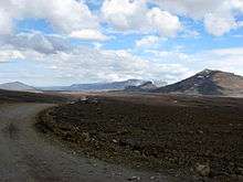
Geography
The road begins in the south of Iceland near Haukadalur and behind the Gullfoss waterfall, ending in the north near Blönduós. The road traverses the interior between two glaciers, Langjökull and Hofsjökull. It is the second longest of the roads through the Highlands of Iceland. It takes about 5 hours to traverse by car.
See also
Routes through the interior highlands of Iceland | ||
|---|---|---|
|  | |
This article is issued from Wikipedia. The text is licensed under Creative Commons - Attribution - Sharealike. Additional terms may apply for the media files.