Route 1 (Iceland)
Route 1 or the Ring Road (Icelandic: Þjóðvegur 1 or Hringvegur) is a national road in Iceland that runs around the island and connects most of the inhabited parts of the country. The total length of the road is 1,322 kilometres (821 mi). Some of the most popular tourist attractions in Iceland, such as the Seljalandsfoss and Skógafoss waterfalls, Dyrhólaey and the Jökulsárlón glacier lagoon, are easily accessible from the Ring Road. The road was completed in 1974, coinciding with the 1,100th anniversary of the country's settlement[2] when the longest bridge in Iceland,[3] crossing the Skeiðará river in the southeast, was opened.
| |
|---|---|
| Þjóðvegur 1 | |
.png) | |
| Route information | |
| Length | 1,322 km[1] (821 mi) |
| Highway system | |
| National Roads in Iceland | |

Characteristics
For almost all its length, the road is two lanes wide: one lane going in each direction. Where it passes through larger towns, the number of lanes may be increased, as it also is in the Hvalfjörður Tunnel. Many smaller bridges are single lane, especially in eastern Iceland, and are constructed of wood or steel. The road is paved with asphalt for all of its length.[4] The Iceland Road Administration, Vegagerðin, oversees the maintenance and building of both main roads and minor roads.
Small portions of the road may contain potential hazards such as blind curves and blind summits, single-lane bridges or narrow passes, although many recent road construction projects have reduced hazardous sections considerably. As of 2019, the road is now fully paved. In winter, icy roads and strong winds, 15 m/s for cars with trailers, 25 m/s for cars without trailers, can make travel hazardous. The maximum speed on most of the road is 90 kilometres per hour (56 mph), though this may be lowered to 70 kilometres per hour (43 mph) in tunnels and 50 kilometres per hour (31 mph) through most urban areas.
Driving in winter
With adequate snow removal, most of Route 1 is kept open over the winter, but some parts are temporarily closed. Most notably, this used to affect the route between Breiðdalsvík and Egilsstaðir (over the Breiðdalsheiði plateau) in the east; although it was open in spring, summer and autumn.[5] Instead, travelers used the somewhat sinuous coastal route via Reyðarfjörður, using (now former) Routes 96 and 92 to travel between the towns. That coastal route became officially part of Route 1 starting in November 2017, replacing the Breiðdalsheiði route, which is now numbered as Route 95.[6]
Natural hazards
Route 1 crosses a few glacial plains, such as Skeiðarársandur, which made the original road construction difficult. In addition, the Skeiðarársandur plain is subject to frequent glacial floods during or after eruptions on the nearby Grímsvötn volcano. Bridges and other stretches of road over the plain have had to be rebuilt as a result.
Traffic
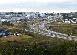
Traffic levels on the road vary considerably between locations: in and near Reykjavík around 10,000–20,000 vehicles use the road daily, but the stretches farthest away from larger towns see an average of fewer than 100 vehicles per day. The Ring Road is popular with tourists since it covers most of the country and many sights of interest are located near to the route. It has long been a popular tour with Icelandic families going on summer vacation, but in recent years the route is becoming more popular with foreign tourists who either rent a car or bring their own on the ferry to Seyðisfjörður.
Sections
The route goes by many names depending on its location. The following table shows road names (excluding tunnels) in a clockwise direction from Reykjavík.
| Name | Location |
|---|---|
| Vesturlandsvegur | Eastern Reykjavík to Borgarnes |
| Borgarbraut | Borgarnes |
| Hringvegur | Borgarnes to northern Akureyri |
| Hörgárbraut | Akureyri |
| Glerárgata | Akureyri |
| Drottningarbraut (partial) | Akureyri |
| Hringvegur | Southern Akureyri to the turning for Höfn |
| Suðurlandsvegur | Höfn to Hella |
| Suðurlandsbraut | From Hella to Selfoss |
| Austurvegur | Selfoss |
| Suðurlandsvegur | From Selfoss to eastern Reykjavík |
Major links
Route 1 includes a number of bridges and a few tunnels. The most notable are:
- Hvalfjörður Tunnel
- Almannaskarð Tunnel
- Fáskrúðsfjarðargöng
- Vaðlaheiði Tunnel
List of cities and towns on Route 1
Travelling clockwise (initially northward) from Reykjavík, the following communities and settlements are located on Route 1.
In popular culture
During the 2016 summer solstice, the Icelandic band Sigur Rós filmed and broadcast a live Slow TV event tour of Iceland driving along the entire route. The event was broadcast live in 360-degree video with a soundtrack of constantly evolving music based around elements of their track Óveður.[7]
Gallery
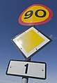 Road sign
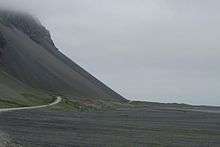
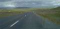 A typical stretch of Route 1, in Borgarfjörður
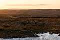
 Road conditions are monitored in real time by a system of weather stations and webcams, such as this station at Vatnsskarð pass in north Iceland.
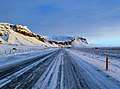 An icy stretch of Route 1 between Vík í Mýrdal and Höfn
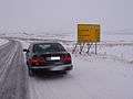 Distance sign (southbound) near Egilsstaðir
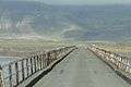 Bridge crossing
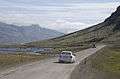 Unpaved stretch between Egilsstaðir and Höfn
References
- "Vegalengdir (Distances between places)" (in Icelandic). Icelandic Road Administration. Retrieved 12 February 2014.
- "Iceland: Milestones in Icelandic History". Iceland.vefur.is. Retrieved 2010-04-17.
- The Road System - 2012. Icelandic Road Administration, ICERA.
- "Vegasjá". Retrieved 2020-01-24.
- "Mokstursdagar" (in Icelandic). Icelandic Road Administration. Retrieved 12 February 2014.
- Geir Finnsson (9 November 2017). "Changes To Ring Road This Weekend". Iceland Review. Retrieved 14 November 2017.
- "sigur rós - route one". Sigur Rós official website. Retrieved 21 September 2016.
External links
| Wikimedia Commons has media related to Hringvegur. |
| Wikivoyage has a travel guide for Route 1-Ring Road. |
- Gateway to Iceland
- Official Icelandic Road Administration
- Driving in Iceland
- Photos from Iceland Ring Road
- Iceland videos
- Iceland’s Ring Road: The Ultimate Road Trip
- Iceland Meteorology Bureau
- Umferðarstofa - Road Traffic Directorate
- Gateway to Iceland
- The Many Reasons Why the Ring Road is the Best Option for Your Travel Plans to Iceland
