Kirkby Stephen
Kirkby Stephen (/ˈkɜːrbi/) is a civil parish and small market town in Cumbria, in North West England. Historically it was part of Westmorland. The town lies on the A685, surrounded by sparsely populated hill country, and about 25 miles (40 km) from the nearest larger towns, Kendal and Penrith. The River Eden rises 6 miles (9.7 km) away in the peat bogs below Hugh Seat and passes by the eastern edge of the town, almost unnoticeably. Kirkby Stephen has a parish council and acts as a centre for surrounding villages and parishes, including Nateby, Ravenstonedale and Mallerstang. A community and council centre in the library provides information and services for all the local councils (county, district and parish).
| Kirkby Stephen | |
|---|---|
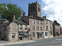 A view over North Road and the Old Forge, with Kirkby Stephen Parish Church beyond | |
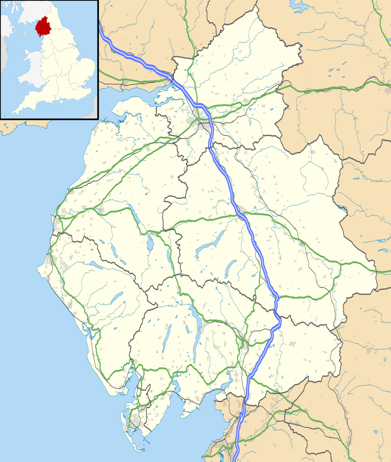 Kirkby Stephen Location within Cumbria | |
| Population | 1,822 (2011 census)[1] |
| OS grid reference | NY7708 |
| Civil parish |
|
| District |
|
| Shire county | |
| Region | |
| Country | England |
| Sovereign state | United Kingdom |
| Post town | KIRKBY STEPHEN |
| Postcode district | CA17 |
| Dialling code | 017683 |
| Police | Cumbria |
| Fire | Cumbria |
| Ambulance | North West |
| UK Parliament | |
Town geography and history
Parish church
Schools
There are primary schools in Kirkby Stephen and in the neighbouring parishes of Brough and Ravenstonedale.
Secondary education for the town and surrounding area is provided by Kirkby Stephen Grammar School. This was founded in 1566 by Thomas Wharton, 1st Baron Wharton, under letters patent granted by Queen Elizabeth I. Although it has retained the name "grammar school", its old buildings were replaced long ago, and it is now a comprehensive school and Sports College with approximately 410 pupils. Within the grounds of the grammar school there was at one time an open-air swimming pool built in the 1960s for the school and local community, which was open from May to August to members of the Kirkby Stephen and District Swimming Club and to visitors to the area.[2]
Market
In 1352–1353, Roger de Clifford, Baron of Westmorland, obtained a charter from King Edward III for a market and two annual fairs to be held in the town. This was reaffirmed by a charter granted in 1605 to George, Earl of Cumberland, by King James I, for "one market on Monday and two fairs yearly; one on the Wednesday, Thursday and Friday after Whitsuntide and the other on the two days next before the feast of St. Luke."
The Monday market, with livestock sales at the Mart in Faraday Road and stalls on Market Square, remains an important event in the town and surrounding countryside. There were special celebrations to mark the 400th anniversary of the King James charter. St Luke's Fair, or "Charter Day", is celebrated every year at the end of October, when the Charter is read at the "Charter Stone" in Market Street. The special "Tup sales", very important in this sheep-rearing area, still take place at around this time each year.
Other facilities
The town has a range of shops: several antique shops, restaurants, cafés, pubs, and an Upper Eden Visitor Centre. Kirkby Stephen has won several awards from Cumbria/Britain in Bloom.
Kirkby Stephen serves as a base for tourism in the Upper Eden Valley area and for walking tours of the Valley. It is on the route of the Coast to Coast Walk, devised by Alfred Wainwright,[3] Each June there is held the "Mallerstang Horseshoe and Nine Standards Yomp", which takes a strenuous route along the high ground on both sides of the neighbouring dale of Mallerstang, including Wild Boar Fell and the summit of nearby Nine Standards Rigg.
The surrounding countryside attracts walkers. There is a Kirkby Stephen Mountain Rescue Team to assist those not fully prepared for harsh conditions on the fell tops.
Faraday connection
It is sometimes said that Faraday Road (parallel with High Street and Market Street) is named in honour of the scientist, Michael Faraday (1791–1867), but in fact it remembers his uncle, Richard Faraday, who was a respected local tradesman. Richard's younger brother James was for some time the blacksmith in Outhgill, but his third child, Michael, was born soon after they had moved to London. The Faraday brothers moved from Clapham in the West Riding to the Kirkby Stephen area because the family were all members of the Sandemanian sect, and at that time there was locally one of the few Sandemanian communities with a chapel, which stood in the courtyard behind what are now the Costa Coffee premises.
Governance
Kirkby Stephen is in the parliamentary constituency of Penrith and the Border. Neil Hudson was elected its Conservative Member of Parliament at the 2019 General Election, replacing Rory Stewart.
Before Brexit, the town was in the North West England European Parliamentary Constituency.
An electoral ward in the same name exists. This stretches south to Aisgill, with a total population at the 2011 Census of 2,580.[4]
Scenic highlights

- Stenkrith Park is to the south of the town, on the B6259 road to Nateby. The river scenery marks a change from limestone at the head of the Eden Valley in Mallerstang to the red sandstone characteristic further along the Eden Valley. The main rock, from which most houses in Kirkby Stephen are built, is brockram, composed of fragments of limestone in a cement of red sandstone. The river at Stenkrith has carved this rock into many fantastic shapes, collectively known as the Devil's Grinding Mill or Devil's Hole. This natural scenery has been supplemented, in recent years, by three human additions.
- The ‘Poetry Path' has 12 stones, which were carved by the artist Pip Hall and bear poems by Meg Peacock that depict a year in the life of a hill farmer.[5]
- Eden Benchmarks: Beside the river there is a sculpture by Laura White, entitled ‘Passage', one of the ten "Eden Benchmarks", a series of sculptures that have been placed at intervals along the River Eden from its source in Mallerstang to the Solway Firth.
- The Millennium Bridge was opened in 2002 and provides pedestrian access from the park to a walk along the old south Durham railway track.
Among many other scenic features in the area are: Nine Standards Rigg to the north-east Pendragon Castle and Wild Boar Fell, to the south.
Unlike neighbouring Brough, Kirkby shows no evidence of Roman settlement, but there are many traces of even more ancient eras in the area, including the remains of a large Iron Age earthwork or hill fort known as Croglam Castle, on the south-eastern edge of the town.
Railways
Kirkby Stephen West station, on the Settle–Carlisle line, is located over 1 mile (2 km) south-west of the town. The line keeps to high ground, avoiding any descent into the valleys where possible.
A second, older railway station is Kirkby Stephen East station at the southern edge of the town. Originally a large junction of the South Durham & Lancashire Union Railway and the Eden Valley Railway, the station was reopened by the Stainmore Railway Company in August 2011 as a heritage centre and operational railway representing the 1950s. It is open to visitors every weekend.
Gallery
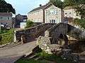 Frank's Bridge
 Kirkby Stephen from the path to Hartley
 River Eden through Kirkby Stephen.
Location grid
See also
References
- "Town population 2011". Retrieved 21 June 2015.
- "Kirkby Stephen, Sports". Archived from the original on 1 January 2010. Retrieved 10 December 2009.
- A Wainwright, Wainwright's Coast to Coast Walk, Michael Joseph, 1987.
- "Ward population 2011". Retrieved 21 June 2015.
External links
| Wikimedia Commons has media related to Kirkby Stephen. |
- Cumbria County History Trust: Kirkby Stephen (nb: provisional research only - see Talk page)
- The Northern Viaducts - Upper Eden Valley
Cumbria Portal | |
| Boroughs or districts | |
| Major settlements |
|
| Topics | |
| Authority control |
|
|---|