Mizan (Dogu'a Tembien)
Mizan is a tabia or municipality in the Dogu'a Tembien district of the Tigray Region of Ethiopia. This tabia includes the rock church of Debre Sema'it, as well as Arefa, reputedly birthplace of the Queen of Sheba. The tabia centre is in Kerene village, located approximately 16 km to the southwest of the woreda town Hagere Selam.
Mizan | |
|---|---|
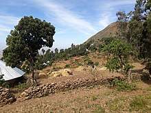
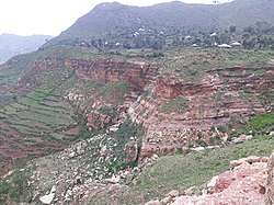 Gumuara village in Mizan | |
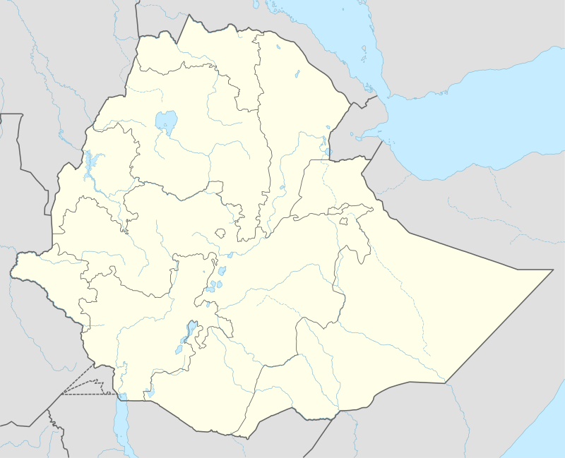 Mizan Location within Ethiopia | |
| Coordinates: 13°35′N 39°3′E | |
| Country | Ethiopia |
| Region | Tigray |
| Zone | Debub Misraqawi (Southeastern) |
| Woreda | Dogu'a Tembien |
| Area | |
| • Total | 31.03 km2 (11.98 sq mi) |
| Elevation | 2,530 m (8,300 ft) |
| Time zone | UTC+3 (EAT) |
Geography
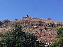
The tabia occupies the Tsilare ridge, that overlooks the wide Tekezze lowlands. At the horizon, across Tekezze River appear the Simien Moutains. The highest area is the plateau in Kerene (2590 m a.s.l.) and the lowest place the foot of the escarpment at Debre Semay'it (1725 m a.s.l.).
Geology
From the higher to the lower locations, the following geological formations are present:[1]
Geological gallery
 Hexagonal outcrop of Ashangi basalts.
 Ashangi basalts in Gumuara.
 Edaga Arbi glacials at the foot of the escarpment.
 Village of Santarfa on a structural flat
Geomorphology and soils
The main geomorphic units, with corresponding soil types are:[2]
- Basalt plateau
- Associated soil types
- Inclusions
- Adigrat Sandstone cliff and footslope
- Associated soil types
- Inclusions
- shallow, dry soils with very high amounts of stones (Leptic and Skeletic Cambisol and Regosol)
- deep, dark cracking clays with good fertility, but problems of waterlogging (Chromic and Pellic Vertisol)
- soils with stagnating water due to an abrupt textural change such as sand over clay (Haplic Planosol]])
Climate
The rainfall pattern shows a very high seasonality with 70 to 80% of the annual rain falling in July and August. Mean temperature in Kerene is 17.8 °C, oscillating between average daily minimum of 9.9 °C and maximum of 25.3 °C. The contrasts between day and night air temperatures are much larger than seasonal contrasts.[3]
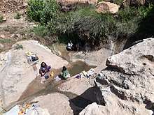
Springs
As there are no permanent rivers, the presence of springs is of utmost importance for the local people. The main springs in the tabia are:[4]
- Debresema'it in the homonymous village
- Debregenet in Kekema
- May Mikale in Tsilere
Reservoirs
In this area with rains that last only for a couple of months per year, reservoirs of different sizes allow harvesting runoff from the rainy season for further use in the dry season.
- Traditional surface water harvesting ponds, particularly in places without permanent springs, called rahaya
- Horoyo, household ponds, recently constructed through campaigns[5]
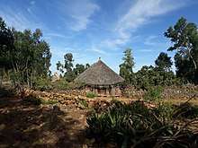
Settlements
The tabia centre Kerene holds a few administrative offices, a health post, a primary school, and some small shops.[4] There are a few more primary schools across the tabia. The main other populated places are:[6]
|
|
Agriculture and livelihood
The population lives essentially from crop farming, supplemented with off-season work in nearby towns. The plateau is dominated by farmlands on Vertisols which are clearly demarcated and are cropped every year. Hence the agricultural system is a permanent upland farming system.[7] The farmers have adapted their cropping systems to the spatio-temporal variability in rainfall.[8]
History and culture
History
The history of the tabia is strongly confounded with the history of Tembien.
Religion and churches
Most inhabitants are Orthodox Christians. The following churches are located in the tabia:
- Medhane Alem
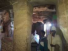
- Debre Sema'it Yohannes (rock church)
- Tsilare Mika'el
- Qeqema Maryam
- Yeresere Abune Ayezgi

Legends and myths
Arefa, at the western side of the tabia and end of the Tsilere ridge, is reputedly the birthplace of the Queen of Sheba. The inhabitants have many legends about her, that all play in and around the rugged mountains of Dog'ua Tembien (Arefa, Megesta, Gelebeda).[9]
Roads and communication
The main road Mekelle – Hagere Selam – Abiy Addi runs through the eastern part of the tabia. There are regular bus services to these towns. Further, a rural access road links Kerene to the main asphalt road.
Schools
Almost all children of the tabia are schooled,[10] though in some schools there is lack of classrooms, directly related to the large intake in primary schools over the last decades.[11] Schools in the tabia include Yeresere school.
Tourism
Its mountainous nature and proximity to Mekelle makes the tabia fit for tourism.[12]
Touristic attractions
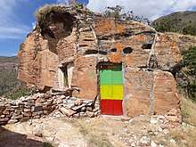
- The Yohannes rock church at Debre Sema'it (13°34.62′N 39°2.24′E) is located in the top of a rock pinnacle. This church has been hewn in Adigrat Sandstone.[13]
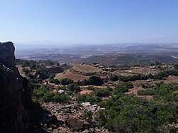
- All along the top of the Tsilere ridge, when the sky is clear, there are good views towards the Simien Mountains, a hundred kilometres away, across Tekezze River.
- The Hagere Selam – Abiy Addi road passes along the foot of the Tsilere ridge, with good views to the escarpment, the Debre Sema'it rock church, and apses in the Adigrat sandstone.
- The high variability of geological formations and the rugged topography invite for geological and geographic tourism or "geotourism".[14]

Trekking routes
Trekking routes have been established in this tabia.[13] The tracks are not marked on the ground but can be followed using downloaded .GPX files.[15]
- Trek 7, is from Abiy Addi across Arefa to the Debre Sema'it rock church, and further along the Tsilare ridge to Inda Maryam Qorar
- Trek 19, from Agbe to Debre Sema'it, and then it continues along the same line as Trek 7
Both treks involve a vertical interval of more than one kilometer and require good physical conditions.
Accommodation and facilities
Though facilities are basic, the inhabitants are hospitable.[16]
See also
- Dogu'a Tembien district.
References
- Sembroni, A.; Molin, P.; Dramis, F. (2019). Regional geology of the Dogu'a Tembien massif. In: Geo-trekking in Ethiopia's Tropical Mountains - The Dogu'a Tembien District. SpringerNature. ISBN 978-3-030-04954-6.
- Nyssen, Jan; Tielens, Sander; Gebreyohannes, Tesfamichael; Araya, Tigist; Teka, Kassa; Van De Wauw, Johan; Degeyndt, Karen; Descheemaeker, Katrien; Amare, Kassa; Haile, Mitiku; Zenebe, Amanuel; Munro, Neil; Walraevens, Kristine; Gebrehiwot, Kindeya; Poesen, Jean; Frankl, Amaury; Tsegay, Alemtsehay; Deckers, Jozef (2019). "Understanding spatial patterns of soils for sustainable agriculture in northern Ethiopia's tropical mountains". PLOS One. 14 (10): e0224041. doi:10.1371/journal.pone.0224041. PMC 6804989. PMID 31639144.
- Jacob, M. and colleagues (2019). Dogu'a Tembien's Tropical Mountain Climate. In: Geo-trekking in Ethiopia's Tropical Mountains - The Dogu'a Tembien District. SpringerNature. doi:10.1007/978-3-030-04955-3_3. ISBN 978-3-030-04954-6.
- What do we hear from the farmers in Dogu'a Tembien? [in Tigrinya]. Hagere Selam, Ethiopia. 2016. p. 100.
- Developers and farmers intertwining interventions: the case of rainwater harvesting and food-for-work in Degua Temben, Tigray, Ethiopia
- Jacob, M. and colleagues (2019). Geo-trekking map of Dogu'a Tembien (1:50,000). In: Geo-trekking in Ethiopia's Tropical Mountains - The Dogu'a Tembien District. SpringerNature. ISBN 978-3-030-04954-6.
- Nyssen, J.; Naudts, J.; De Geyndt, K.; Haile, Mitiku; Poesen, J.; Moeyersons, J.; Deckers, J. (2008). "Soils and land use in the Tigray highlands (Northern Ethiopia)". Land Degradation and Development. 19 (3): 257–274. doi:10.1002/ldr.840.
- Frankl, A. and colleagues (2013). "The effect of rainfall on spatio‐temporal variability in cropping systems and duration of crop cover in the Northern Ethiopian Highlands". Soil Use and Management. 29 (3): 374–383. doi:10.1111/sum.12041.
- Seifu Gebreselassie; Lanckriet, S. (2019). Local myths in relation to the natural environment of Dogu'a Tembien. In: Geo-Trekking in Ethiopia's Tropical Mountains, the Dogu'a Tembien District. SpringerNature. ISBN 978-3-030-04954-6.
- Socio-demographic profile, food insecurity and food-aid based response. In: Geo-trekking in Ethiopia's Tropical Mountains - The Dogu'a Tembien District. SpringerNature. 2019. ISBN 978-3-030-04954-6.
- Hartjen, C.A. and Priyadarsini, S., 2012. Denial of Education. In The Global Victimization of Children (pp. 271-321). Springer, Boston, MA. https://link.springer.com/chapter/10.1007/978-1-4614-2179-5_8 .
- Geo-trekking in Ethiopia's Tropical Mountains - The Dogu'a Tembien District. SpringerNature. 2019. ISBN 978-3-030-04954-6.
- Description of trekking routes in Dogu'a Tembien. In: Geo-trekking in Ethiopia's Tropical Mountains - The Dogu'a Tembien District. SpringerNature. 2019. ISBN 978-3-030-04954-6.
- Miruts Hagos and colleagues (2019). Geosites, Geoheritage, Human-Environment Interactions, and Sustainable Geotourism in Dogu'a Tembien. In: Geo-Trekking in Ethiopia's Tropical Mountains, the Dogu'a Tembien District. SpringerNature. doi:10.1007/978-3-030-04955-3_1. ISBN 978-3-030-04954-6.
- https://www.openstreetmap.org/traces/tag/nyssen-jacob-frankl
- Nyssen, Jan (2019). "Logistics for the Trekker in a Rural Mountain District of Northern Ethiopia". Geo-trekking in Ethiopia's Tropical Mountains. GeoGuide. Springer-Nature. pp. 537–556. doi:10.1007/978-3-030-04955-3_37. ISBN 978-3-030-04954-6.