Abergele (woreda)
Tanqua Abergele (Tigrinya: ጣንቋ ኣበርገለ) is one of the woredas in the Tigray Region of Ethiopia. Part of the Mehakelegnaw Zone, Abergele is bordered on the south and west by the Amhara Region, then by the Tekezé River on the west which separates it from Amhara Region and the Semien Mi'irabawi (North Western) Zone, on the north by Kola Tembien, on the east by Degua Tembien and on the southeast by the Debub Misraqawi (South Eastern) Zone. The administrative center of this woreda is Yechila; other towns in Abergele include Sele and Jijike. Abergele is one of the low lying districts of central Tigray and the Tanqua River, which originates near Hagere Selam, flows through this woreda and joins the Geba just north of Jijike. It further feeds the Tekezze River. The Tekezé Dam is also located in this woreda.

Tanqua Abergele ጣንቋ ኣበርገለ | |
|---|---|
 | |
 Flag | |
 | |
| Country | Ethiopia |
| Region | Tigray |
| Zone | Mehakelegnaw |
| Area | |
| • Total | 2,407.88 km2 (929.69 sq mi) |
| Population (2007) | |
| • Total | 93,185 |
History
It was a constituent of the old Tembien awrajja.[1] Historically, Abergele seems to have formed a province since early times (perhaps the 14th century). It was governed by a shum in the reign of Lebna Dengel and Susenyos (16th-17th century). According to the chronicle of atse Yohannes I, the people of Abergele joined the rebellion, which was led by Fares and Zayohannes and suppressed by abeto Dalbe Iyesus in 1678.[2]
Nowadays Abergele is bounded by Enderta in the east, Sekota in the south and qolla Tembien, in the northern and western directions. It assumes a unique position mainly for its trilinguistic makeup. Its inhabitants constitute the sole Agaw enclave in Tigray, but the majority speaks Tigrinya and some Amharic as well.[3] In terms of religion, however, they are predominantly adherents of Christianity. Very few of them practice Islam.
Agriculture forms the main stay of Abergele economic life. As elsewhere in most districts of Tembien, social services are hardly developed. The first schools and health centers of the calling are just emerging. This was partly attributed to the region's relative geographic remoteness from the center.[1] This seclusion and strategic position at the cross-roads of Wollo, Tigray, and Gondar, seemed to have made it a safe abode for political dissidents for over centuries.[4] It hoisted series of protracted armed encounters between the chiefs of these regions including that of Yejju.[5]
Rock church
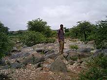
Abergele holds a rock-hewn or monolithic church. It has literally been hewn from rock, probably before the 10th C. CE,[6][7][8] and is located along the slopes of the Degua Tembien massif. The Kidane Mihret rock church of Addi Nefas (13°33.3′N 39°1.44′E) is hewn from Adigrat sandstone.[9][6] Further up, in the Degua Tembien mountains at the northeast, there are an additional eight rock churches and natural caves with a church at its entrance.[9]
Demographics
The population pyramid has a wide base, not unlike most other low-income countries. However, the two lower age groups show that the pyramid base has stopped widening; this concerns particularly the group of 0–9 years old with an even more pronounced effect in the group of 0–4 years old, thus indicating a timid onset of a demographic transition. This may be related to the improved health services and a changing position of women in the society. Indeed, a revised Family Code came into effect in 2000, advocating the principles of gender equality. This raised the minimum age of marriage from 15 to 18 years old and established women rights in terms of sharing any assets the household has accumulated. The Ethiopian penal code states that it is a crime to beat one's wife, and harmful traditional practices such as early marriage, abduction and female genital mutilation are now also considered to be a crime. Nowadays, almost all children are going to school but girls frequently drop out when they reach the age of 13 to 15 years: schools have no facilities for menstrual hygiene management and this is a major reason to interrupt schooling.[10]
Based on the 2007 national census conducted by the Central Statistical Agency of Ethiopia (CSA), this woreda has a total population of 93,185, except an increase of 59.64% over the 1994 census, of whom 47,512 are men and 45,673 women; 7,035 or 7.55% are urban inhabitants. With an area of 2,407.88 square kilometers, Abergele has a population density of 38.70, which is less than the Zone average of 56.29 persons per square kilometer. A total of 19,775 households were counted in this woreda, resulting in an average of 4.71 persons to a household, and 18,767 housing units. The majority of the inhabitants said they practiced Ethiopian Orthodox Christianity, with 98.91% reporting that as their religion.[11]
The 1994 national census reported a total population for this woreda of 58,373, of whom 29,541 were men and 28,832 were women; 2,334 or 4% of its population were urban dwellers. The two largest ethnic groups reported in Abergele were the Tigrayan (97.93%), and the Agaw Kamyr (1.82%); all other ethnic groups made up 0.25% of the population. Tigrinya was spoken as a first language by 98.17%, and 1.43% spoke Kamyr; the remaining 0.4% spoke all other primary languages reported. 99.83% of the population practiced Ethiopian Orthodox Christianity, and 0.12% were Muslim. Concerning education, 5.92% of the population were considered literate, which is less than the Zone average of 14.21%; 4.04% of children aged 7–12 were in primary school; a negligible number of the children aged 13–14 were in junior secondary school, and a negligible number of the inhabitants aged 15–18 were in senior secondary school. Concerning sanitary conditions, about 72% of the urban houses and 19% of all houses had access to safe drinking water at the time of the census; none of the urban and 1.6% of the total had toilet facilities.[12]
Agriculture
Cropping
A sample enumeration performed by the CSA in 2001 interviewed 15,123 farmers in this woreda, who held an average of 1.63 hectares of land. Of the 24,690 hectares of private land surveyed, 87% was in cultivation, 0.2% pasture, 11% fallow, and 1.7% was devoted to other uses. For the land under cultivation in this woreda, 82% was planted in cereals, 2.3% in pulses, 3% in oilseeds, and 0.02% in vegetables. Four hectares were planted in fruit trees and 18 in gesho. Land tenure in this woreda is distributed amongst 85% owning their land, and 15% renting; the percentage reported as holding their land under other forms of tenure is missing.[13]
Livestock
In 2001, 89% of the farmers both raised crops and livestock, while 10% only grew crops and 0.5% only raised livestock.[14]
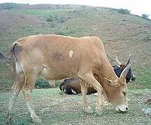
Mainly used for draught, among the different cattle landraces in Tigray,[15][16] Abergele is outstanding, as it holds its own landrace, the small and resistant Abergele cattle.[17] Other varieties include the Arado cattle, the widely dominant variety of adjacent districts. In addition, long-horned Raya oxen are purchased from Southern Tigray as draught animals.
Reservoirs
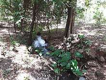
In this district with rains that last only for a couple of months per year, most rivers (for instance May Selelo and Zikuli Rivers) run dry after the end of the rainy season. Hence, reservoirs of different sizes allow harvesting runoff from the rainy season for further use in the dry season. Besides the larger Tekezé Dam, the reservoirs of the district include Aqushela. Overall, these reservoirs suffer from rapid siltation.[18][19] Part of the water that could be used for irrigation is lost through seepage; the positive side-effect is that this contributes to groundwater recharge.[20]

Surrounding woredas
Places adjacent to Abergele (woreda) | |
|---|---|
Notes
- Igziabher, Taddesse Gabre (1972). Power Struggle in Tigray During Zamana Masafint. Addis Ababa: Haile Sellassie I University.
- Guidi, Ignazio (1903). Annales Iohannis I, Iyāsu I et Bakāffā. Paris: E Typographeo Reipublicae. p. 25.
- Rossini, Carlo Conti (1904). "Note sugli Agau: 1. Appunti sulla lingua khamta dell' Averghellé". Giornale della Società Asiatica Italiana. 17: 183–242.
- Huntingford, George Wynn Brereton (1989). The Historical Geography of Ethiopia: From the First Century AD to 1704. London: Union Académique Internationale.
- Berhe, Tsegay (1996). A History of Agame, 1822-1914. Addis Ababa: Addis Ababa University.
- Sauter, R. "Eglises rupestres du Tigré". Annales d'Ethiopie. 10: 157–175. doi:10.3406/ethio.1976.1168.
- Plant, R.; Buxton, D. (1970). "Rock-hewn churches of the Tigre province". Ethiopia Observer. 12 (3): 267.
- Gerster, G. (1972). Kirchen im Fels – Entdeckungen in Äthiopien. Zürich: Atlantis Verlag.
- Nyssen, J. (2019). Description of Trekking Routes in Dogu'a Tembien. GeoGuide. Cham (CH): SpringerNature. pp. 557–675. doi:10.1007/978-3-030-04955-3_38. ISBN 978-3-030-04954-6.
- Nyssen, J.; De Rudder, F.; Vlassenroot, K.; Fredu Nega; Azadi, Hossein (2019). Socio-demographic profile, food insecurity and food-aid based response. In: Nyssen J., Jacob, M., Frankl, A. (Eds.). Geo-trekking in Ethiopia's Tropical Mountains - The Dogu'a Tembien District. SpringerNature. ISBN 978-3-030-04954-6.
- Census 2007 Tables: Tigray Region Archived 2010-11-14 at the Wayback Machine, Tables 2.1, 2.4, 2.5 and 3.4.
- 1994 Population and Housing Census of Ethiopia: Results for Southern Nations, Nationalities and Peoples' Region, Vol. 1, part 1 Archived 2008-11-19 at the Wayback Machine, Tables 2.1, 2.12, 2.19, 3.5, 3.7, 6.3, 6.11, 6.13 (accessed 30 December 2008)
- "Central Statistical Authority of Ethiopia. Agricultural Sample Survey (AgSE2001). Report on Area and Production - Tigray Region. Version 1.1 - December 2007" Archived 2009-11-14 at the Wayback Machine (accessed 26 January 2009)
- "Central Statistical Authority of Ethiopia. Agricultural Sample Survey (AgSE2001). Report on Area and Production - Tigray Region. Version 1.1 - December 2007" Archived 2009-11-14 at the Wayback Machine (accessed 26 January 2009)
- Merha Zerabruk; Vangen, O; Mitiku Haile (2007). "The status of cattle genetic resources in North Ethiopia: On-farm characterization of six major cattle breeds". Animal Genetic Resources Information. 40: 15–32. doi:10.1017/S1014233900002169.
- Cattle breeds, milk production, and transhumance in Dogu'a Tembien. In: Geotrekking in Ethiopia's tropical mountains, Chapter 28. Cham: SpringerNature. 2019. doi:10.1007/978-3-030-04955-3_28.
- Merha Zerabruk; Vangen, O (2005). "The Abergelle and Irob cattle breeds of North Ethiopia: description and on-farm characterization". Animal Genetic Resources Information Bulletin. 36: 7–20. doi:10.1017/S101423390000184X.
- Vanmaercke, M. and colleagues (2019). "Sediment Yield and Reservoir Siltation in Tigray". Geo-trekking in Ethiopia's Tropical Mountains. GeoGuide. Cham (CH): Springer Nature. pp. 345–357. doi:10.1007/978-3-030-04955-3_23. ISBN 978-3-030-04954-6.
- Nigussie Haregeweyn, and colleagues (2006). "Reservoirs in Tigray: characteristics and sediment deposition problems". Land Degradation and Development. 17: 211–230. doi:10.1002/ldr.698.
- Nigussie Haregeweyn, and colleagues (2008). "Sediment yield variability in Northern Ethiopia: A quantitative analysis of its controlling factors". Catena. 75: 65–76. doi:10.1016/j.catena.2008.04.011.
Woredas of the Mehakelegnaw Zone | ||
|---|---|---|
| ||