Abiy Addi
Abiy Addi (also spelled Abi Addi; Tigrigna ዓብዪ ዓዲ "Big town") is a town in central Tigray, Ethiopia. It has a latitude and longitude of 13°37′23″N 39°00′06″E with an elevation ranging from 1917 to 2275 meters above sea level. Abiy Addi is at the southeastern edge of the Kola Tembien woreda, of which it is the capital.
Abiy Addi ዓብዪ ዓዲ | |
|---|---|
 Older houses in Abiy Addi | |
 Flag | |
 Abiy Addi Location within Ethiopia | |
| Coordinates: 13°37′23″N 39°00′06″E | |
| Country | Ethiopia |
| Region | Tigray |
| Zone | Mehakelegnaw (Central) |
| Elevation | 1,950 m (6,400 ft) |
| Population (2007) | |
| • Total | 16,115 |
| Time zone | UTC+3 (EAT) |
Overview
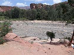
The town is divided into two parts by the Tanqwa River, the lower part being the more respectable part while the upper part "is where you'll find the marketplace ... and the seedier bars in which you're most likely to see Awris dancing as the myes hits the mark." Many customers will prefer the siwa local beer. Briggs notes that Abiy Addi is known in Tigray for the frenetic style of dancing called "Awris", as well as the quality of its honey.[1][2]
Having visited Abiy Abbi in the mid-1940s, David Buxton thought that "perhaps the best thing about Abbi Addi was the panorama of the Simien mountains standing to the west beyond the deep valley of the Tekezé." Buxton notes that the entire height of that mountain range was visible, from the southern foothills to the summit. "And round about the lower slopes, dimly seen through the haze, were many fantastic outlying peaks, square or spiky, like the mountains of a child's imagination."[3] As for the town itself, Philip Briggs describes it as "a reasonably substantial settlement, set in a dusty valley below an impressive cliff."[1]
Abiy Addi is connected to Adwa by an all-weather gravel road which runs through Maykinetal, which has a total length of 100 kilometers; it was rehabilitated between May 2003 and April 2005 at a cost of 54.6 million Birr.[4]
History
19th Century
Abiy Addi owed its importance in the 19th century due to its location on the "King's Road", at the point where the road south from Adwa split, one branch taking travellers to Debre Tabor and the other to the Lake Ashenge region.[5] The British explorer Charles Beke passed through this town (which he called "A'biyad") 15 April 1843, and described it later as "the principal place of Tembien, and a large market-town."[6] However, in later years the fortunes of the town varied. By 1890, visitors described Abiy Addi as a small market town which handled various imported goods, such as mirrors made in France, cotton cloth from Manchester and Mumbai, as well as the usual local produce.[7] Writing a few years later, Augustus B. Wylde described the Abiy Addi market, held on Saturdays, as of medium size.[8]
20th Century
On 5 December 1935, during the Second Italo-Ethiopian War, Abiy Addi was occupied by the Italian Eritrean Corps. the town was evacuated later that month. Then, after having been headquarters of Ras Kassa Haile Darge and Ras Seyoum Mengesha, it was definitely reoccupied by the Italians on 28 February 1936. A rock-hewn church served as the shelter of Ras Kassa.[7]
In 1938, there were shops and restaurants in Abiy Addi, a telephone and telegraph office, a health post and a school. There was also an important market. At May Lomin, there were gardens with bananas, coffee and lemons.[9]
With only minimal forces the Tigrayan People's Liberation Front (TPLF) had captured the lightly defended Abiy Addi in 1976 and controlled it for almost a year before being forced out of the town by superior Derg Forces. The Red Terror was particularly brutal in this town, undoubtedly because of the TPLF's support in this area. During a market day in July 1977, the Derg executed 178 people in the town square, claiming that they were thieves. Eyewitnesses report that most of the victims were peasants, many of whom had travelled from the neighboring woreda of Adet to buy salt because of shortages at home.[7]
In the following years, Abiy Addi exchanged hands between the TPLF and the Derg was bombed by the Derg thirteen times, 340 houses were burnt or destroyed, and over 400 of the town's inhabitants were killed or wounded. This violence caused many people to leave the area, some for Mekele, and others as far as the liberated territories around Shiraro where even merchants took up farming. On 1 March 1985 Abiy Addi was bombed on a market day. In 1988, the TPLF took definite control of Abiy Addi, and held it to the conclusion of the Ethiopian Civil War.[7] However, the Derg attacked the town twice that year, once with helicopters, killing almost 50 people.[10]
Demographics
In 1867, Abiy Addi was described as a “Mahomedan place” with, on market days, “about 2,000 people assembled in the market place”.[11] In 1938, the town counted approximately 20 000 inhabitants (which was very large for that time).[9]
Based on the 2007 national census conducted by the Central Statistical Agency of Ethiopia (CSA), this town has a total population of 16,115, of whom 7,826 are men and 8,289 women. The majority of the inhabitants said they practiced Ethiopian Orthodox Christianity, with 88.59% reporting that as their religion, while 11.31% of the population were Muslim.[12] The 1994 census reported it had a total population of 7,884 of whom 3,545 were men and 4,339 were women.
Geology
From the higher to the lower locations, the following geological formations are present:[13]
Tourism
Its mountainous nature and proximity to Mekelle makes Abiy Addi fit for tourism.[14]
Geotouristic sites
The high variability of geological formations and the rugged topography invite for geological and geographic tourism or “geotourism”.[15] Geosites in the tabia include:
- Geramba Sillasie rock church
- Chege forest
- May Lomin gorge and springs
- Arefa, reputedly birthplace of the Queen of Sheba
Trekking routes
Trekking routes link Abiy Adi with the nearby Dogu’a Tembien mountain district.[16] The tracks are not marked on the ground but can be followed using downloaded .GPX files.[17]
- Route 6, from Abiy Addi, through May Lomin to Hagere Selam
- Route 7, from Abiy Addi, through Debre Semay’it rock church to Inda Maryam Qorar
- Route 25, from Itsiwto, through Geramba to Melfa
Each trek requires a full day and good physical condition.
References
- Philip Briggs, Ethiopia: The Bradt Travel Guide, 3rd edition (Chalfont St Peters: Bradt, 2002), p. 270
- Smidt, W. (2019). "A Short History and Ethnography of the Tembien Tigrayans". Geo-trekking in Ethiopia's Tropical Mountains. GeoGuide. Cham, Switzerland: SpringerNature. pp. 63–78. doi:10.1007/978-3-030-04955-3_4. ISBN 978-3-030-04954-6.
- David Buxton, Travels in Ethiopia, second edition (London: Ernest Benn, 1957), p. 123
- "SUR Construction PLC - Major Projects" Archived 2010-02-26 at the Wayback Machine, SUR Construction webpage (accessed 6 May 2010
- Richard Pankhurst, Economic History of Ethiopia (Addis Ababa: Haile Selassie University, 1968), p. 284
- Charles T. Beke, "Abyssinia: Being a Continuation of Routes in That Country", Journal of the Royal Geographical Society of London, 14 (1844), p. 62
- "Local History in Ethiopia" Archived 2011-05-28 at the Wayback Machine The Nordic Africa Institute website (accessed 11 December 2007)
- Augustus B. Wylde, Modern Abyssinia (London: Methuen, 1901), p. 494
- Consociazione turistica Italiana. Guida dell'Africa orientale Italiana. Milano. p. 281.
- Africa Watch, Ethiopia: "Mengistu has Decided to Burn Us like Wood": Bombing of Civilians and Civilian Targets by the Air Force, 24 July 1990, p. 10
- https://books.google.be/books?id=Pz39jymjOY0C&printsec=frontcover#v=onepage&q&f=false Henri James, 1867. Routes in Abyssinia. London, Harrison and Sons.
- Census 2007 Tables: Tigray Region Archived 2010-11-14 at the Wayback Machine, Tables 2.1, 2.4, 2.5 and 3.4.
- Sembroni, A.; Molin, P.; Dramis, F. (2019). Regional geology of the Dogu'a Tembien massif. In: Geo-trekking in Ethiopia's Tropical Mountains - The Dogu'a Tembien District. SpringerNature. ISBN 978-3-030-04954-6.
- Geo-trekking in Ethiopia's Tropical Mountains - The Dogu'a Tembien District. SpringerNature. 2019. ISBN 978-3-030-04954-6.
- Miruts Hagos and colleagues (2019). Geosites, Geoheritage, Human-Environment Interactions, and Sustainable Geotourism in Dogu'a Tembien. In: Geo-Trekking in Ethiopia's Tropical Mountains, the Dogu'a Tembien District. SpringerNature. doi:10.1007/978-3-030-04955-3_1. ISBN 978-3-030-04954-6.
- Nyssen, Jan (2019). Description of Trekking Routes in Dogu'a Tembien. GeoGuide. Springer-Nature. pp. 557–675. doi:10.1007/978-3-030-04955-3_38. ISBN 978-3-030-04954-6.
- https://www.openstreetmap.org/traces/tag/nyssen-jacob-frankl
Places adjacent to Abiy Addi | ||||||||||
|---|---|---|---|---|---|---|---|---|---|---|
| ||||||||||