Kentucky Route 57
Kentucky Route 57 is an 88.035-mile-long (141.679 km) state highway in the U.S. Commonwealth of Kentucky. The western terminus is at KY 4 (New Circle Road) in eastern Lexington. The eastern terminus is at KY 8 on the banks of the Ohio River in Concord. The road runs generally southwest to northeast.
| ||||
|---|---|---|---|---|
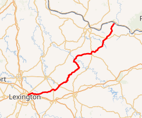
KY 57 highlighted in red | ||||
| Route information | ||||
| Maintained by KYTC | ||||
| Length | 88.035 mi[1] (141.679 km) | |||
| Major junctions | ||||
| West end | ||||
| ||||
| East end | ||||
| Location | ||||
| Counties | Fayette, Bourbon, Nicholas, Fleming, Lewis | |||
| Highway system | ||||
| ||||

The road is two-lane for its entire length, except for a short distance near the southwestern terminus, where, as Bryan Station Road, KY 57 is four lanes wide with a center turn lane for a fraction of a mile, then two lanes plus a center turn lane for another fraction of a mile.
Major intersections
| County | Location | mi | km | Destinations | Notes |
|---|---|---|---|---|---|
| Fayette | Lexington | 0.000 | 0.000 | Southern terminus; road continues southwest into downtown Lexington as Bryan Avenue | |
| 3.050 | 4.908 | Western terminus of KY 1970 | |||
| 6.756 | 10.873 | ||||
| 7.800 | 12.553 | Southern terminus of KY 2335 | |||
| 8.078 | 13.000 | Northern terminus of KY 859 | |||
| Bourbon | Clintonville | 11.547 | 18.583 | ||
| | 16.643 | 26.784 | |||
| North Middletown | 22.530 | 36.259 | South end of US 460 concurrency; 3364 to the west and north | ||
| 22.737 | 36.592 | North end of US 460 concurrency | |||
| Plum | 27.752 | 44.663 | South end of KY 537 overlap | ||
| 27.853 | 44.825 | North end of KY 537 overlap | |||
| | 29.283 | 47.126 | Western terminus of KY 1198 | ||
| Nicholas | | 35.233 | 56.702 | Southern terminus of KY 1285 | |
| Moorefield | 38.344 | 61.709 | South end of KY 36 concurrency | ||
| 38.722 | 62.317 | North end of KY 36 concurrency | |||
| Sprout | 42.161 | 67.852 | Southern terminus of KY 3315 | ||
| | 43.061 | 69.300 | Eastern terminus of KY 928 | ||
| | 47.457 | 76.375 | South end of KY 32 concurrency | ||
| Fleming | | 52.481 | 84.460 | Eastern terminus of KY 681 | |
| | 53.186 | 85.595 | Southern terminus of KY 560 | ||
| | 56.099 | 90.283 | Southern terminus of KY 165 | ||
| Elizaville | 56.812 | 91.430 | |||
| Flemingsburg | 60.590 | 97.510 | Northern terminus of KY 1325 | ||
| 60.784 | 97.822 | North end of KY 32 concurrency; south end of KY 11 concurrency; western terminus of KY 32 business route | |||
| 61.917 | 99.646 | ||||
| 62.363 | 100.364 | North end of KY 11 concurrency; northern terminus of KY 11 business route | |||
| | 63.039 | 101.451 | |||
| | 64.091 | 103.144 | Northern terminus of KY 57 business route | ||
| | 64.930 | 104.495 | Western terminus of KY 3301 | ||
| | 65.811 | 105.913 | Southern terminus of KY 3299 | ||
| | 70.587 | 113.599 | Western terminus of KY 344 | ||
| Lewis | | 72.933 | 117.374 | South end of KY 1237 overlap | |
| | 73.627 | 118.491 | North end of KY 1237 overlap | ||
| | 76.103 | 122.476 | |||
| Tollesboro | 76.675 | 123.396 | South end of KY 10 concurrency | ||
| 76.812 | 123.617 | North end of KY 10 concurrency | |||
| | 82.176 | 132.249 | Western terminus of KY 984 | ||
| Concord | 88.035 | 141.679 | Western terminus of KY 8; eastern terminus of KY 3350 | ||
1.000 mi = 1.609 km; 1.000 km = 0.621 mi
| |||||
Flemingsburg business route
| |
|---|---|
| Location | Flemingsburg |
| Length | 2.753 mi[1] (4.431 km) |
Kentucky Route 57 Business (KY 57 Bus.) is an 2.753-mile-long (4.431 km) business route through Flemingsburg.
Major intersections
The entire route is in Fleming County.
| Location | mi[1] | km | Destinations | Notes | |
|---|---|---|---|---|---|
| Flemingsburg | 0.000 | 0.000 | Southern terminus; south end of KY 32 Bus. overlap | ||
| 0.921 | 1.482 | Northern terminus of KY 2503 | |||
| 1.165 | 1.875 | North end of KY 32 Bus. overlap | |||
| 1.220 | 1.963 | ||||
| | 2.753 | 4.431 | Northern terminus | ||
1.000 mi = 1.609 km; 1.000 km = 0.621 mi
| |||||
References