Kentucky Route 170
Kentucky Route 170 (KY 170) is a 14.362-mile-long (23.113 km) state highway in Kentucky that runs from KY 1325 in rural Fleming County southwest of Flemingsburg to KY 324 in rural Mason County southeast of May's Lick.
| ||||
|---|---|---|---|---|
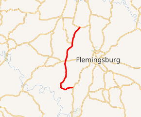
KY 170 highlighted in red | ||||
| Route information | ||||
| Maintained by KYTC | ||||
| Length | 14.362 mi[1] (23.113 km) | |||
| Major junctions | ||||
| South end | ||||
| North end | ||||
| Location | ||||
| Counties | Fleming, Mason | |||
| Highway system | ||||
| ||||

A portion of the route, between KY 1325 and KY 1347, was formerly designated as KY 57. It was redesignated so as to make KY 57 a continuous route and to eliminate a gap due to no bridge crossing the Licking River.
Major intersections
| County | Location | mi[1] | km | Destinations | Notes |
|---|---|---|---|---|---|
| Fleming | | 0.000 | 0.000 | Southern terminus | |
| | 2.078 | 3.344 | Northern terminus of KY 1347 | ||
| | 6.494 | 10.451 | |||
| | 6.747 | 10.858 | Southern terminus of KY 367 | ||
| | 8.448 | 13.596 | Western terminus of KY 559 | ||
| Flemingsburg Junction | 9.581 | 15.419 | Southern terminus of KY 161 | ||
| | 9.728 | 15.656 | Western terminus of KY 860 | ||
| Mason | | 14.362 | 23.113 | ||
| 1.000 mi = 1.609 km; 1.000 km = 0.621 mi | |||||
References
- Division of Planning. "Highway Information System Official Milepoint Route Log Extract". Kentucky Transportation Cabinet. Retrieved November 3, 2015.
This article is issued from Wikipedia. The text is licensed under Creative Commons - Attribution - Sharealike. Additional terms may apply for the media files.