Kaukapakapa
Kaukapakapa is a town in the North Island of New Zealand. It is situated in the Rodney district and is around 50 kilometres (31 miles) northwest of Auckland. State Highway 16 passes through the town, connecting it to Helensville about 12 km (7.5 miles) to the south-west, and Araparera about 14 km to the north. The North Auckland Line also passes through Kaukapakapa. The Kaukapakapa River flows from the town to the Kaipara Harbour to the west.[1][2]
Kaukapakapa | |
|---|---|
 Kaukapakapa | |
| Coordinates: 36°36′58″S 174°29′29″E | |
| Country | |
| Region | Auckland |
| Territorial authority | Auckland Council |
| Ward | Rodney |
| Population (2018) | |
| • Total | 2,484 |
"Kaukapakapa" is a Māori name meaning "to swim with much splashing".[3] The town is commonly known to the locals in its shortened form "Kaukap".[4]
History
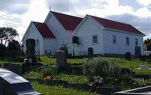
European settlement of the area began in 1860, when the Government bought land from local Māori.[5] A small number of settlers arrived from England and Scotland, and a Methodist church was built in 1872. A monthly boat service operated between Kaukapakapa and the northern Kaipara from 1863.[6] The population of the area was 311 in 1881. The town developed split between the northern and southern banks of the river. Although roads connected the town to Riverhead, Tauhoa and Helensville by the early 1880s, they were of poor quality, and most access was by the river.[7] The roads were still mostly unmetalled in 1920.[8]
The kauri timber industry was responsible for developing the area, with logs floated down the Kaukapakapa River to the Kaipara Harbour, where they were loaded onto ships for export. Gum-digging (beginning in 1873-74 and continuing until at least 1914)[9] and flax processing (in the 1880s)[10] were also significant early industries. A shipyard operated from 1864 and into the 1880s.[11]
The North Auckland railway line reached Kaukapakapa in 1889.[12] A creamery was built next to the railway station to service the developing dairy industry.[13][14]
Genesis Energy has proposed to build a gas-fired power station near Kaukapakapa. The proposal is opposed by the Kaukapakapa Residents & Ratepayers Association and Kaipara Forest and Bird.[15]
Demographics
| Historical population | ||
|---|---|---|
| Year | Pop. | ±% p.a. |
| 2006 | 1,695 | — |
| 2013 | 2,010 | +2.46% |
| 2018 | 2,484 | +4.33% |
| Source: [16] | ||
The statistical area of Te Kuru, which at 81 square kilometres is larger than the town of Kaukapakapa, had a population of 2,484 at the 2018 New Zealand census, an increase of 474 people (23.6%) since the 2013 census, and an increase of 789 people (46.5%) since the 2006 census. There were 792 households. There were 1,233 males and 1,251 females, giving a sex ratio of 0.99 males per female. The median age was 38.8 years, with 561 people (22.6%) aged under 15 years, 414 (16.7%) aged 15 to 29, 1,254 (50.5%) aged 30 to 64, and 255 (10.3%) aged 65 or older.
Ethnicities were 93.4% European/Pākehā, 11.2% Māori, 2.4% Pacific peoples, 2.7% Asian, and 2.3% other ethnicities (totals add to more than 100% since people could identify with multiple ethnicities).
The proportion of people born overseas was 21.1%, compared with 27.1% nationally.
Although some people objected to giving their religion, 61.2% had no religion, 27.7% were Christian, and 3.4% had other religions.
Of those at least 15 years old, 348 (18.1%) people had a bachelor or higher degree, and 255 (13.3%) people had no formal qualifications. The median income was $42,400. The employment status of those at least 15 was that 1,122 (58.3%) people were employed full-time, 327 (17.0%) were part-time, and 45 (2.3%) were unemployed.[16]
Governance
Kaukapakapa is part of the Local Government Rodney Ward of Auckland Council and is part of the Kumeu Subdivision of the Rodney Local Board.
Kaukapakapa is in the Helensville Electorate however proposed Boundary changes in late 2019 could change this.
Economy
The township is in the North West Country Inc business improvement district zone. The business association which represents businesses from Kaukapakapa to Riverhead.
Education
Kaukapakapa School is a coeducational full primary school (years 1-8), with a roll of 279 students as of March 2020.[17][18] The school celebrated its 125th reunion in 1998.[19]
Kaukapakapa also has two early learning institutions: The Kaukapakapa Pre-School, located near the primary school, and a Playcentre located in Macky Road. (Established in 1976) [20]
Publications
Kaukapakapa's only local publication dedicated to Kaukapakapa news and events is the Kaukapakapa Kourier, a free newsletter delivered to local residents by post and also available online in PDF format.[21]
Notable people
- Clint Brown - former TV3 News Anchor
- Tony Woodcock - Former All Black prop
References
- Peter Dowling (editor) (2004). Reed New Zealand Atlas. Reed Books. map 11. ISBN 0-7900-0952-8.CS1 maint: extra text: authors list (link)
- Roger Smith, GeographX (2005). The Geographic Atlas of New Zealand. Robbie Burton. map 34. ISBN 1-877333-20-4.
- Reed, A.W. (1996) The Reed Dictionary of Mǎori Place Names: Te Papakupu Ingoa Wǎhi Mǎori a Reed (3rd ed.). Reed Books: Auckland, New Zealand
- "Kaukapakapa Travel Guide". Jasons Travel Media.
- Ryburn, Wayne (1999). Tall Spars, Steamers & Gum. Auckland, N.Z.: Kaipara Publications. p. 25. ISBN 0-473-06176-7.
- Ryburn, p. 30.
- Ryburn, pp. 49-50, 86-87, 89.
- Ryburn, pp. 187-188.
- Ryburn, pp. 42, 201.
- Ryburn, p. 139.
- Ryburn, pp. 43-44, 138.
- Ryburn, pp. 83-84.
- Ryburn, p. 62.
- "Kaukapakapa". Helensville Museum. Retrieved 2008-09-06.
- Thompson, Wayne (22 August 2008). "Parties warming up on power station hearing". The New Zealand Herald.
- "Statistical area 1 dataset for 2018 Census". Statistics New Zealand. March 2020. Te Kuru (111600). 2018 Census place summary: Te Kuru
- "New Zealand Schools Directory". New Zealand Ministry of Education. Retrieved 26 April 2020.
- Education Counts: Kaukapakapa School
- "Jubilees & reunions - Kaukapakapa School". Education Gazette New Zealand. 77 (13). 3 August 1998.
- "Playcentre Details Kaukapakapa". Archived from the original on 2015-01-26.
- "Kaukapakapa Kourier".