Kattippara
Kattippara (Hard Rock in Malayalam) often called as Kattipara, is a Panchayat in Kozhikode district, Kerala.[1] It is located about 10 km from Thamarassery town. It is a village with a lot of hilly areas. As the name indicates, it is famous for hard rocks which we can find everywhere in this village. The adjacent villages are Thalayad, Chamal, Kolikkal, Unnikulam, Puthupadi and Thamarassery.
Kattippara Kattippara | |
|---|---|
Town | |
 Kattippara Location in Kerala, India  Kattippara Kattippara (India) | |
| Coordinates: 11°21′40″N 76°0′35″E | |
| Country | |
| State | Kerala |
| District | Kozhikode |
| Government | |
| • Member of Parliament | M K Raghavan |
| • MLA (Koduvally) | Karat Razak |
| • Panchayath President | Baby Raveendran |
| Area | |
| • Total | 21.29 km2 (8.22 sq mi) |
| Population (2001) | |
| • Total | 30,123 |
| • Density | 1,400/km2 (3,700/sq mi) |
| Languages | |
| • Official | Malayalam, English |
| Time zone | UTC+5:30 (IST) |
| PIN | 673573 |
| Sex ratio | 1000:1040 ♂/♀ |
| Literacy | 88% |
| Lok Sabha constituency | Kozhikode |
| Vidhan Sabha constituency | Koduvally |
| Climate | pleasant (Köppen) |
History
The name 'Kattipara' was formed from hard rocks which was used by the early occupants of this area and the people who came from other places for agriculture and other people.
Economy
The major source of income in this village is agriculture. Majority of the population depend on the agriculture crops such as rubber, coconut, arecanut, ginger, pepper etc. A very minority only depend on business and govt. jobs. There are many self-help groups, small scale industries and a kudumba shree units active in this place. Other major sources of the people are products of agriculture, daily wagers, constructions and other businesses.
Tourism
The major tourist places in this village are Kualamala and Amaradu Mala which are good for trekking and sightseeing. Wild animals like monkeys, deers, wild pigs, wild buffaloes and a large variety of insects and birds are found in the innermost forest area of both Kulamala and Amarad.
Climate
Kattippara has a generally cool humid climate with a very hot season extending from March to May. The average annual rainfall is more than 3500 mm and it is the highest rain fall in this region.
Demographics
Population consists of mainly Christian, Hindu and Muslim communities.
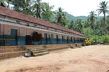
Nazareth LP School, Kattippara
Educational institutions
Holy Family Higher Secondary School and Nazareth U.P. School are the major educational institutions (both are aided) in this village and students from nearby places also depend on these schools for their formal and secondary education. Other than these institutions there are preliminary schools, KGs and andanavadis.
Government Institutions
The Kattipara Gram Panchayath is the major government institution in this locality which has Thamarassery, Poonor, Puthupadi and Thalayad as its borders. Other institutions include Kattipara Veterinary Hospital, Government Homeo Dispensory, Akshaya e kendra, branches of various banks, etc.
Transportation
Kattippara village connects to other parts of India through Calicut city on the west and Thamarassery town on the east. National highway No.66 passes through Kozhikode and the northern stretch connects to Mangalore, Goa and Mumbai. The southern stretch connects to Cochin and Trivandrum. The eastern National Highway No.54 going through Adivaram connects to Kalpetta, Mysore and Bangalore. The nearest airports are at Kannur and Kozhikode. The nearest railway station is at Kozhikode.
References
- "gloriousindia.com". Retrieved 2 May 2010.
| Wikimedia Commons has media related to Koduvally. |