Karlskrona
Karlskrona (UK: /ˈkɑːrlskroʊnə/,[2] US: /kɑːrlzˈkruːnə/,[3] Swedish: [kaɭsˈkrûːna] (![]()
Karlskrona | |
|---|---|
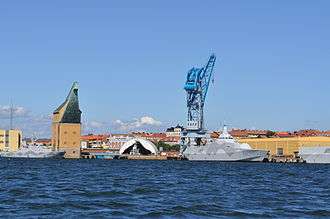
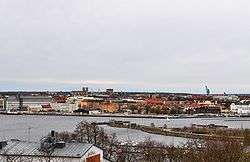 Skyline of Karlskrona in May 2010 | |
 Coat of arms | |
 Karlskrona  Karlskrona | |
| Coordinates: 56°9′39″N 15°35′10″E | |
| Country | Sweden |
| Province | Blekinge |
| County | Blekinge County |
| Municipality | Karlskrona Municipality |
| Charter | 1680 |
| Area | |
| • Total | 21.72 km2 (8.39 sq mi) |
| Elevation | 16 m (52 ft) |
| Population (31 December 2018)[1] | |
| • Total | 66 675 |
| • Density | 1,621/km2 (4,200/sq mi) |
| Time zone | UTC+1 (CET) |
| • Summer (DST) | UTC+2 (CEST) |
| Postal code | 371 xx |
| Area code(s) | (+46) 455 |
| Website | www |
| Official name | Naval Port of Karlskrona |
| Includes |
|
| Criteria | Cultural: (ii)(iv) |
| Reference | 871 |
| Inscription | 1998 (22nd session) |
| Area | 320.417 ha (1.23714 sq mi) |
| Buffer zone | 1,105.077 ha (4.26673 sq mi) |
Geography
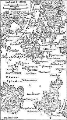
The city of Karlskrona is spread over 30 islands in the eastern part of Blekinge archipelago, Trossö being the main one;.[4] Other populated mentionable islands are Saltö, Sturkö, Hästö, Långö and Aspö. The islet of Stumholmen was formerly property of the Navy and today it houses the National Naval Museum (Marinmuseum). Outside the city lies the archipelago of Karlskrona, the most southern of the Swedish archipelagos. Several islands are connected to the city by ferries.
History
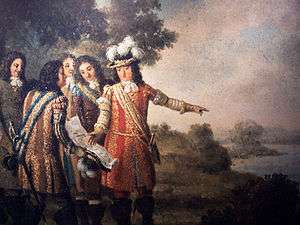
The city was founded on 10 August 1680[5] when the Royal Swedish Navy was relocated from the Stockholm area to the Trossö island which had up until then been used chiefly for farming and grazing. At the time Sweden was the dominant military power in the Baltic sea region, but needed a better strategic location against Denmark, since southern parts of Sweden had been conquered only a few decades before (see the Torstenson War). The Swedish fleet tended to get stuck in the ice during winter while located close to Stockholm and was therefore moved south. The island had a very strategic position with short sailing distances to the German and Baltic provinces. The city name means Karl's Crown in honour of King Karl XI of Sweden, the name being inspired by the name of the city Landskrona.
The city grew quickly and by 1750 Karlskrona had about 10,000 inhabitants. It was then one of the biggest cities in the country. Most of the baroque buildings from this era are still standing, which is why the city centre is architecturally uniform.
The shipyard in Karlskrona was established almost at the same time as the city. It was a necessity because of the heavy losses the Swedish navy had suffered in 1659. In 1711, the shipyard was Sweden's largest industrial employer with 1,100 workers. The oldest dock, the Polhem dock, is cut in the cliff itself and is still in use. It got its name from Christopher Polhem ("The Swedish da Vinci", a famous scientist with several inventions still in use). There is also a historical rope making factory, Repslagarbanan, that is now open for guided tour.
The city has kept its street structure since its foundation. Since the streets all follow a grid pattern the winds can blow freely from the sea right into the heart of the city.
Parts of the city (mainly the Naval Port) have been declared a UNESCO World Heritage Site.[6]
In October 1981 the Whiskey-class Soviet submarine S-363 (known as "U137" in Sweden) ran aground in the archipelago near Sturkö just outside Karlskrona. The media characterized it as the "Whiskey on the Rocks" affair. The incident caused a temporary rise in tensions between Sweden and the Soviet Union. While the submarine's grounding was inadvertent, and likely the result of inebriation among the crew, the submarine almost certainly was engaged in an unspecified covert mission at the time.
Culture and heritages
The most important day in Karlskrona is the day before midsummer's eve. On that day a big fair takes place and attracts tens of thousands to visit Karlskrona. The fair is called Lövmarknaden (The Leaf Fair) and is very popular among the locals.
The main square of Karlskrona is the biggest in Scandinavia.
Every year in late July/early August a popular festival called The Sail takes place in the harbor of Karlskrona. Usually it is a place where families go to have something to eat and drink, and perhaps watch the sailing boats lined up at the pier. During the sail, the seascouts of Karlskrona will row a boat carrying torches along the docks while playing the national anthems for the visiting ships.
Lately The Sail has been replaced with a festival called Skärgårdsfest.[7]
The old architecture together with the naval installations comprise the major tourist attractions of Karlskrona. The city has a pleasant atmosphere and is one of the highlights of south-east Sweden.
Architectural Heritage
Karlskrona has preserved its buildings and its layout virtually intact since its foundation.
When the city was founded in 1680, it was primarily thought of as a military city, with many defenses and fortifications exploiting the particular topography of the city. Some fortifications were located on the main island (Trossö) such as the Bastion Aurora, built at the beginning of the 18th century,[8] but much of it was located on the nearby islands (Ljungskär, Mjölnareholmen, Godnatt, Koholmen and Kurrholmen) or more distant, such as the islands closing the bay, with in particular the important fortress of Kungsholmen and its circular port.[9]
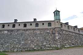 Bastion Aurora
 Västra kruthuset
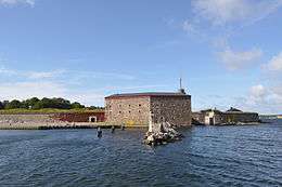 The Kungsholmen fort
 The circular harbor of Kungsholmen
But the civil part of the city was also carefully planned. It has a rectangular grid plan, with however some diagonal streets, created because of the relief of the city center. Nicodème Tessin l'Ancien was responsible for the design of the buildings, and he gave the city a very uniform baroque style.
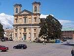
The central building of the city is the Fredrikskyrkan church, built in the 1690s,[10] On the main square, which is also the highest point of the island. Several other churches are located in the city, such as the Church of the Holy Trinity, built for the Germans of the city in 1709,[11] ou encore Amiralitetskyrkan, consacrée en 1685[12]
 The Fredrikskyrkan Church
 Church of the Holy Trinity
 Amiralitetskyrkan
In front of the Amiralitetskyrkan church is the statue of Rosenbom, made famous by the children's book of Selma Lagerlöf, The Wonderful Adventures of Nils, in which the statue tells the story of the c.[13] Near the church is also the Admiralstorn Tower, dating from 1699, originally used to indicate the time for the shipyard workers but used since 1909 as the church tower[14] The ma is seen holding some text in Swedish. The English translation of that text is "I humbly beg of you, even though my voice may be weak, come and put a penny in but first lift my hat. Blessed are those that care for the poor." which is the last sentance in the bible. Nearby, there is paper with the translation of that text, the translated languages are English, German, Polish, Danish, Norwegian, and Finish. The English translation is written by Gorge Hopkins.
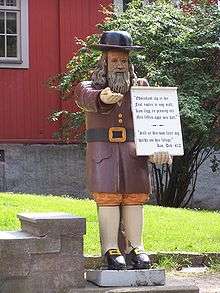 The statue of Rosenbom
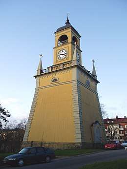 Admiralstorn
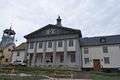
Finally, the city has some more recent buildings, such as the model room, having hosted between 1780 and 1920 models of boats,[15] Now transferred to the Marine Museum, or the town hall built after the fire of 1790.[16] Finally, the county building (Länsresidenset) built between 1909 and 1911.[17]
 The model room
 City Hall
 Länsresidenset
Museums

The most visited museum of the city is the Naval Museum, with around 250 000 visitors a year. About half of those visitors are Swedish, the other half from other countries.[18] The Naval Museum is Sweden's national museum for the history of the Swedish Navy. Along with exhibitions, the museum contains object collections, a drawings archive, photographic archive and a library. The museum is also involved in research.
The present museum building on Stumholmen in Karlskrona was opened in 1997 by the present king Carl XVI Gustaf. Before that the museum lay in the former cadet barracks in the naval harbour, Örlogshamnen, and until 1963 was known as the Shipyard Museum (Varvsmuseet).
The museum is based on the "model room" created in 1752 by Adolphe-Frédéric of Sweden, in which several boat models were stored in order to test different types of structures.[19] Nowadays, these models still form the core of the museum's collection, but the museum also traces the history of the Royal Swedish Navy.[19]
The city is also home to the Blekinge Museum, with 82,443 visitors in 2008.[20]
Economy
Some of the biggest employers in Karlskrona are Telenor, Ericsson and Roxtec. The city has an overall strong presence in information technology based industries.
Transport
The city is positioned at the south east corner of Sweden with excellent connections to the other side of the Baltic Sea. There is a ferry line to Gdynia in Poland transporting both goods and passengers provided by the ferry operator Stena Line.
Most of the islands of Karlskrona are connected by roads. One of the bigger populated Islands Aspö is connected with a small road ferry. Boats also travel between the archipelago's various islands during the summer months.
Truck transport
The city is close to the European Highway 22, connected by a small section of highway, part of the national road 28. The E22 connects the main cities of southern Sweden such as Malmö, Lund, Kristianstad, then climbs along the east coast towards Kalmar and Norrköping. The national road 28 connects the Karlstad to Emmaboda.
Rail transport

The city being one of the most important in Sweden, with in particular a large shipyard, the need for railway was great.[21] The city received its first railway line in 1874, connecting it to Växjö, which itself was connected since 1865 to the main line Södra stambanan.[21] The line then came to the north of the city center of Karlskrona. The shipyard, further south, was connected in 1888, thanks to an underground line of 2 km, but the line closed in 1990.[21] This line is now part of the Kust till Kust banan, linking Göteborg and Kalmar.[22] The town received a new railway line in 1889 when the future Blekinge kustbana, linking Kristianstad to Karlskrona, was built.[23]
Religion
There are three important churches in Karlskrona. Fredrikskyrkan (The Frederick church) was designed by Nicodemus Tessin the Younger, who was influenced by Italian architecture. The foundation of that church were laid in 1720, and it was inaugurated in 1744. It differs from usual Swedish churches in its orange color, adornment and its two towers despite not being a bishop's church.
Trefaldighetskyrkan (Church of Holy Trinity), also called The German Church, was built between 1697–1709, following Tessin's drawings. It is likewise located at the market square in the centre core. The dome-shaped roof also takes its influence from Italian architecture and is rarely seen on Swedish churches.
Karlskrona Admiralty Church (Amiralitetskyrkan) was built in 1685 in red-painted wood and is one of Sweden's largest wooden churches. Outside the church there is a well-known statue called Rosenbom.
Parishes
- Karlskrona City Parish (from 10 August 1680)
- Karlskrona German Parish (from 10 August 1680 to 1 November 1846)
- Karlskrona Prisoner's Parish (from 1808 to 4 July 1866)
- The Mosaic Parish in Karlskrona (1785 to 1994)
- Royal Karlskrona Admiralty Parish (from 1681, a non-territorial parish)

There is also a Catholic Church, St Klara, at Lindesnäsvägen 2b, 371 45 Karlskrona
Education

The city is the main campus of Blekinge tekniska högskola, an Institute of Technology founded in 1989,[28] which is one of the few högskolor (university colleges) in Sweden with the right to issue a doctorate,[29] Thus having a status quite similar to that of a real university. The institute employs about 600 people and hosts about 8,000 students.[28]
Sports
The following sports clubs are located in Karlskrona:
- Karlskrona HK
- FK Karlskrona
- Hästö IF
- Pillagers HC
In literature
In The Surgeon's Mate by Patrick O'Brian, Karlskrona is the base for the British Baltic fleet, approximately 1813, when the two nations were at peace with each other and allied against Napoleon. Captain Jack Aubrey and Stephen Maturin start an action to free a group of Catalan forces still in French service on a fictional island on the Pomeranian coast. The estimable Vice Admiral Sir James Saumarez is still in command of the Baltic fleet for the purpose of the novel.
Gallery
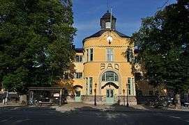
 Karlskrona city public library
 Museum Lionardo da Vinci Ideale
 Kapellparken
- Admiralstorn (bell tower)
- Gunpowder House
 The shipyard Karlskronavarvet with the old crane
 Fiskbron, the old harbour in centre of karlskrona
- Bastion Aurora
 Bath-house in Karlskrona
 Milestone in Karlskrona
 Nils Holgersson, statue made by Ralf Borselius
 Statue of King Charles XIII
References
- "Kommunfakta och statistik2 2018" (in Swedish). Karlskrona kommun. 31 December 2018. Archived from the original on 27 January 2012. Retrieved 10 January 2012.
- "Karlskrona". Collins English Dictionary. HarperCollins. Retrieved 24 April 2019.
- "Karlskrona". Merriam-Webster Dictionary. Retrieved 24 April 2019.
- Berezin, Henrik (30 April 2006). Adventure Guide Scandinavia: Sweden, Norway, & Denmark. Hunter Publishing, Inc. pp. 120–. ISBN 978-1-58843-579-8. Retrieved 1 July 2012.
- "Grattis Karlskrona, 337 år!" (in Swedish). Blekinge läns tidning. 10 August 2017. Retrieved 10 August 2018.
- "Karlskrona". www.worldheritagesite.org. Retrieved 7 May 2017.
- "Hem - Karlskrona Skärgårdsfest". www.karlskronaskargardsfest.se.
- "The Aurora Bastion". The naval city of Karlskrona. Retrieved 14 March 2011..
- "Fortifications". The naval city of Karlskrona. Retrieved 14 March 2011..
- "The Fredrik Church". The naval city of Karlskrona. Retrieved 14 March 2011..
- "The Church of the Holy Trinity". The naval city of Karlskrona. Retrieved 14 March 2011..
- "The Admiralty Church". The naval city of Karlskrona. Retrieved 14 March 2011..
- "Gubblen Rosenbom". Karlskrona (in Swedish). Archived from the original on 12 January 2012. Retrieved 14 March 2011..
- "The Admiralty Clock Tower". The naval city of Karlskrona. Retrieved 14 March 2011..
- "The Ships´ Models Room and Mustering Hall". The naval city of Karlskrona. Retrieved 14 March 2011..
- "The Town Hall". The naval city of Karlskrona. Retrieved 14 March 2011..
- "Upplev länsresidenset i Karlskrona och skärgårdens befästningar". Stats fastighetsverk (in Swedish). Archived from the original on 9 September 2012. Retrieved 14 March 2011..
- "Om Marinmuseum". www.marinmuseum.se (in Swedish). Retrieved 2017-08-04.
- "About". Marinmuseum. Archived from the original on 7 December 2010. Retrieved 14 March 2011..
- "Museer & Konsthallar 2008" (PDF). Kulturrådet (in Swedish). Archived from the original (PDF) on 3 December 2013. Retrieved 11 March 2011..
- "Emmaboda-Karlskrona". Järnväg (in Swedish). Retrieved 14 March 2011..
- "Kust till kust-banan". Trafikverket (in Swedish). Retrieved 14 March 2011..
- "Kristianstad-Karlskrona". Järnväg (in Swedish). Retrieved 14 March 2011..
- "Tidtabeller Karlskrona - Gdynia". Stena Line (in Swedish). Retrieved 14 March 2011..
- "Kommunikationer". Karlskrona (in Swedish). Retrieved 14 March 2011..
- "Destinationer". Swedavia (in Swedish). Archived from the original on 8 March 2011. Retrieved 14 March 2011..
- "Passagerarfrekvens 2009" (PDF). Transportstyrelsen (in Swedish). Archived from the original (PDF) on 21 July 2011. Retrieved 14 March 2011..
- "A short presentation of Blekinge institute of technology". Blekinge tekniska högskola. Archived from the original on 27 December 2010. Retrieved 14 March 2011..
- "Universitet&högskolor Högskoleverkets årsrapport 2009" (PDF). Högskoleverket (in Swedish). Archived from the original (PDF) on 18 August 2010. Retrieved 14 March 2011..
External links
![]()
![]()
- Karlskrona Municipality - Official site
- Photos from Karlskrona
- (in Swedish) article Karlskrona (from online version of Nordisk familjebok)
- . Encyclopædia Britannica (11th ed.). 1911.
Municipalities and seats of Blekinge County | ||
|---|---|---|
| Municipalities | ||
| Municipal seats | ||
 | ||
For official site names, see each article or the List of World Heritage Sites in Sweden. | ||
| East | Flag of Sweden | |
| South |
| |
| North |
| |
| ||