Ronneby Municipality
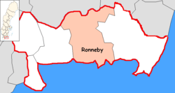
Ronneby Municipality (Ronneby kommun) is a municipality in Blekinge County in South Sweden in southern Sweden. It borders to Tingsryd Municipality, Emmaboda Municipality, Karlskrona Municipality and Karlshamn Municipality. The town of Ronneby is the seat of the municipality.
Ronneby Municipality Ronneby kommun | |
|---|---|
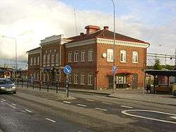 Ronneby Train Station | |
 Coat of arms | |
 | |
| Coordinates: 56°12′N 15°17′E | |
| Country | Sweden |
| County | Blekinge County |
| Seat | Ronneby |
| Area | |
| • Total | 1,241.85 km2 (479.48 sq mi) |
| • Land | 825.34 km2 (318.67 sq mi) |
| • Water | 416.51 km2 (160.82 sq mi) |
| Area as of 1 January 2014. | |
| Population (31 December 2019)[2] | |
| • Total | 29,633 |
| • Density | 24/km2 (62/sq mi) |
| Time zone | UTC+1 (CET) |
| • Summer (DST) | UTC+2 (CEST) |
| ISO 3166 code | SE |
| Province | Blekinge |
| Municipal code | 1081 |
| Website | www.ronneby.se |
The present municipality was created in 1967 through the amalgamation of the City of Ronneby with three surrounding units.
Localities
There are 9 urban areas (also called a Tätort or locality) in Ronneby Municipality.
In the table the localities are listed according to the size of the population as of December 31, 2005. The municipal seat is in bold characters.
| # | Locality | Population |
|---|---|---|
| 1 | Ronneby | 11,767 |
| 2 | Kallinge | 4,767 |
| 3 | Bräkne-Hoby | 1,769 |
| 4 | Johannishus | 773 |
| 5 | Listerby | 672 |
| 6 | Ronnebyhamn | 464 |
| 7 | Backaryd | 399 |
| 8 | Eringsboda | 340 |
| 9 | Hallabro | 252 |
Politics
Ronneby was run by the Social Democratic Party for over 80 consecutive years, until a right wing coalition won the election in 2010. This coalition consists of the Moderate Party (23,5 %), the Center Party (11,8 %), the Peoples Party (5,7%), the Christian Democrats (1,8%) and the Ronneby Party (7,2%). The chairman of the municipal board of directors is moderate Roger Fredriksson. The Ronneby Party is a party with local interests formed before the national election of 1994. In 1998 the party had got 6.3% of the votes and three seats in the municipal council. In 2002 the vote share was reduced to 3.0%.
Parishes
Parishes ordered by hundreds:
- Bräkne Hundred
- Bräkne-Hoby Parish
- Öljehult Parish
- Medelstad Hundred
- Backaryd Parish
- Edestad Parish
- Eringsboda Parish
- Förkärla Parish
- Hjortsberga Parish
- Listerby Parish
- Ronneby Parish
International relations
|
|
|
References
- "Statistiska centralbyrån, Kommunarealer den 1 januari 2014" (in Swedish). Statistics Sweden. 2014-01-01. Archived from the original (Microsoft Excel) on 2016-09-27. Retrieved 2014-04-18.
- "Folkmängd i riket, län och kommuner 31 december 2019" (in Swedish). Statistics Sweden. February 20, 2020. Retrieved February 20, 2020.
Municipalities and seats of Blekinge County | ||
|---|---|---|
| Municipalities | ||
| Municipal seats | ||