Kandahar, Saskatchewan
Kandahar is a hamlet in Rural Municipality of Big Quill No. 308, Saskatchewan, Canada. Listed as a designated place by Statistics Canada, the hamlet had a population of 20 in the Canada 2016 Census.[4] Located on Highway 16 near Wynyard, Saskatchewan, Canada, named by Canadian Pacific Railway executives in the late 19th century for a British military victory in Kandahar, Afghanistan. The hamlet is too small to be enumerated on its own, so its population belongs to the Rural Municipality of Big Quill No. 308. It is located near the south shore of Big Quill Lake, the largest inland body of salt water in Canada.
Kandahar Candahar Post Office | |
|---|---|
Organized hamlet | |
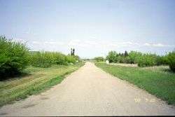 The road into Kandahar in May 2003 | |
 Kandahar Location within Saskatchewan | |
| Coordinates: 51.7581°N 104.3619°W | |
| Country | Canada |
| Province | Saskatchewan |
| Rural Municipality | Big Quill |
| Federal Electoral District | Regina—Qu'Appelle |
| Provincial Constituency | Arm River |
| Government | |
| • Member of the Legislative Assembly | Greg Brkich, (SP) |
| • Member of Parliament | Andrew Scheer |
| Time zone | UTC−6 (Central Standard Time) |
| [1][2][3] | |
History
Many of the first settlers in the Kandahar district were immigrants from Iceland or of Icelandic descent. A significant number arrived from the Argyle settlement in Manitoba.[5] An Icelandic immigrant, Thorvidur Halldorson (born Þorviður Magnússon), served as the district's first postmaster in 1910. From 1910 to 1913, the spelling of the post office was Candahar. Kandahar became a village in 1913, following a petition from its inhabitants. In 1925, Kandahar was listed as a Canadian Pacific Railway Ltd. Station on the Minnedosa, Saskatoon, Edmonton Section, CPR. Businesses included a printing press, Prentsmiðja A. Helgasonar, run by Andres Helgason (1867-1939), who was a skilled bookbinder and printer.[6]
The one room school house was named Kandahar School District #3333.
Until the 1970s, Kandahar was a thriving town with various stores and attractions, including a popular steak house. However, in the late 1980s the village's only school closed, and the population has steadily decreased since.
Demographics
| Canada census – Kandahar, Saskatchewan community profile | |||
|---|---|---|---|
| 2016 | |||
| Population: | 20 (0.0% from 2011) | ||
| Land area: | 0.36 km2 (0.14 sq mi) | ||
| Population density: | 55.6/km2 (144/sq mi) | ||
| Median age: | |||
| Total private dwellings: | 12 | ||
| Median household income: | $N/A | ||
| References: 2016[7] earlier[8] | |||
See also
- List of communities in Saskatchewan
- Hamlets of Saskatchewan
- Designated place
References
- Government of Saskatchewan, MRD Home, Municipal Directory System, archived from the original (– Scholar search) on March 21, 2005, retrieved 2007-04-24
- Canadian Textiles Institute. (2005), CTI Determine your provincial constituency, archived from the original on 2007-09-11, retrieved 2007-04-24
- Commissioner of Canada Elections, Chief Electoral Officer of Canada (2005), Elections Canada On-line, archived from the original on 2007-04-21, retrieved 2007-04-24
- Canada 2016 Census: Designated places in Saskatchewan
- Lindal, W. J. (1946). The Saskatchewan Icelanders: A Strand of the Canadian Fabric. Winnipeg: Columbia Press. pp. 165–167.
- Oleson, G. J. (1 February 1939). "Ferð til Vatnabygða". Heimskringla. p. 2.
- "2016 Community Profiles". 2016 Canadian Census. Statistics Canada. February 21, 2017.
- "2001 Community Profiles". 2001 Canadian Census. Statistics Canada. February 17, 2012.
| Towns | 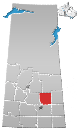 | ||||
|---|---|---|---|---|---|
| Villages | |||||
| Resort villages | |||||
| Rural municipalities | |||||
| First Nations | |||||
| Indian reserves | |||||
| Unincorporated communities |
| ||||