Kama Reservoir
The Kama Reservoir, also known as the Perm Reservoir (Russian: Камское водохранилище, Пермское водохранилище), is a reservoir formed by the dam of the Kama Hydroelectric Station near Perm (constructed in 1954-1956). The Kama Reservoir has a surface area of 1,915 km² and a water volume of 12,2 cubic km. Its length along the Kama is 272 km, major width - up to 30 km, average depth - 6,3 m (with maximum depth equaling 30 m). The Kama Reservoir was created for the benefit of transportation, energetics, and water supply. It also performs seasonal flow regulation. The cities of Perm, Dobryanka, Chyormoz, Berezniki, Usolye, and Solikamsk are located on the shores of the Kama Reservoir.
| Wikimedia Commons has media related to Kama Reservoir. |
The river Kama | ||
|---|---|---|
Left tributary of the Volga | ||
| Tributaries | 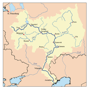 | |
| Reservoirs | ||
| Hydroelectric stations |
| |
| Kama Reservoir Perm Reservoir | |
|---|---|
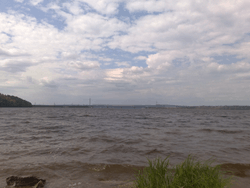 View from the confluence area of the Chusovaya River. | |
| Coordinates | 58°59′N 56°10′E |
| Lake type | reservoir |
| Primary inflows | Kama, Chusovaya, Sylva, Obva, Inva, Kosva |
| Primary outflows | Kama |
| Basin countries | Russia |
| Max. length | 272 km (169 mi) |
| Max. width | 30 km (19 mi) |
| Surface area | 1,915 km2 (739 sq mi) |
| Average depth | 6.3 m (21 ft) |
| Max. depth | 30 m (98 ft) |
| Water volume | 12.2 km3 (2.9 cu mi) |
| Surface elevation | 108.5 m (356 ft) |
| Settlements | Perm, Dobryanka, Chyormoz, Berezniki, Usolye, and Solikamsk |
This article includes content derived from the Great Soviet Encyclopedia, 1969–1978, which is partially in the public domain.