Kaktovik, Alaska
Kaktovik (/kækˈtoʊvɪk/;[6] Inupiaq: Qaaktuġvik, IPA: [qaːktoʁvik]) is a city in North Slope Borough, Alaska, United States. The population was 293 at the 2000 census[7] and 239 as of the 2010 census.[4]
Kaktovik, Alaska | |
|---|---|
City | |
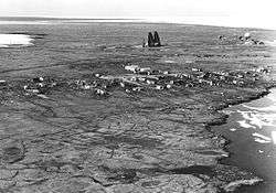 Aerial view of Kaktovik and Barter Island LRRS. | |
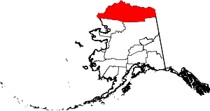 Location in North Slope Borough and the state of Alaska | |
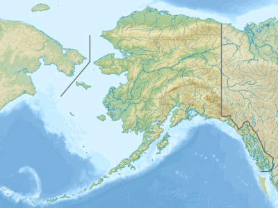 Kaktovik, Alaska Location in the United States of America | |
| Coordinates: 70°07′58″N 143°36′58″W | |
| Country | United States |
| State | Alaska |
| Borough | North Slope |
| Incorporated | March 26, 1971[1] |
| Government | |
| • Mayor | Nora Jane Burns[2] |
| • State senator | Donny Olson (D) |
| • State rep. | John Lincoln (D) |
| Area | |
| • Total | 1.05 sq mi (2.71 km2) |
| • Land | 0.77 sq mi (2.01 km2) |
| • Water | 0.27 sq mi (0.70 km2) |
| Elevation | 36 ft (11 m) |
| Population | |
| • Total | 239 |
| • Estimate (2018)[5] | 256 |
| • Density | 330.75/sq mi (127.65/km2) |
| Time zone | UTC-9 (Alaska (AKST)) |
| • Summer (DST) | UTC-8 (AKDT) |
| ZIP code | 99747 |
| Area code | 907 |
| FIPS code | 02-36990 |
| GNIS feature ID | 1404349, 2419404 |
History
Until the late nineteenth century, Barter Island was a major trade center for the Inupiat and was especially important as a bartering place for Inupiat from Alaska and Inuit from Canada.
Kaktovik was a traditional fishing place—Kaktovik means "Seining Place"—that has a large pond of good fresh water on high ground. It had no permanent settlers until people from other parts of Barter Island and northern Alaska moved to the area around the construction of a runway and Distant Early Warning Line station in the 1950s. The area was incorporated as the City of Kaktovik in 1971.
Due to Kaktovik's isolation, the village has maintained its Inupiat Eskimo traditions. Subsistence is highly dependent upon the hunting of caribou and whale.
In the early twenty-first century Kaktovik became a tourist destination to view polar bears.[8][9]
Geography
Kaktovik is located at 70°7′58″N 143°36′58″W (70.132832, -143.616230).[10]
Kaktovik is on the north shore of Barter Island, between the Okpilak and Jago River on the Beaufort Sea coast. It lies in the 19.6 million acre (79,000 km²) Arctic National Wildlife Refuge.
According to the United States Census Bureau, the city has a total area of 1.0 square mile (2.6 km2), of which, 0.8 square miles (2.1 km2) of it is land and 0.2 square miles (0.52 km2) of it (21.00%) is water.
Transportation
Barter Island LRRS Airport is located near the city.
Climate
Being located at 70°N, Kaktovik experiences a Tundra climate (Köppen ET). Winters are long, very cold and owing to its high latitude the sun does not rise above the horizon leaving only twilight as the source of light during mid-winter. Summers, on the other hand, bring along temperatures slightly above freezing with the midnight sun appearing for a few weeks.
| Climate data for Kaktovik, Alaska | |||||||||||||
|---|---|---|---|---|---|---|---|---|---|---|---|---|---|
| Month | Jan | Feb | Mar | Apr | May | Jun | Jul | Aug | Sep | Oct | Nov | Dec | Year |
| Record high °F (°C) | 37 (3) |
40 (4) |
33 (1) |
43 (6) |
51 (11) |
72 (22) |
83 (28) |
76 (24) |
67 (19) |
48 (9) |
35 (2) |
35 (2) |
83 (28) |
| Average high °F (°C) | −11 (−24) |
−13 (−25) |
−10 (−23) |
7 (−14) |
27 (−3) |
44 (7) |
54 (12) |
50 (10) |
38 (3) |
19 (−7) |
1 (−17) |
−8 (−22) |
17 (−9) |
| Daily mean °F (°C) | −17 (−27) |
−21 (−29) |
−17 (−27) |
−2 (−19) |
22 (−6) |
39 (4) |
47 (8) |
44 (7) |
33 (1) |
14 (−10) |
−5 (−21) |
−14 (−26) |
10 (−12) |
| Average low °F (°C) | −23 (−31) |
−27 (−33) |
−25 (−32) |
−10 (−23) |
16 (−9) |
33 (1) |
39 (4) |
37 (3) |
28 (−2) |
9 (−13) |
−10 (−23) |
−20 (−29) |
4 (−16) |
| Record low °F (°C) | −62 (−52) |
−59 (−51) |
−53 (−47) |
−47 (−44) |
−20 (−29) |
19 (−7) |
28 (−2) |
25 (−4) |
1 (−17) |
−26 (−32) |
−45 (−43) |
−53 (−47) |
−62 (−52) |
| Average precipitation inches (mm) | 0.07 (1.8) |
0.11 (2.8) |
0.04 (1.0) |
0.03 (0.76) |
0.05 (1.3) |
0.17 (4.3) |
0.50 (13) |
0.73 (19) |
0.84 (21) |
0.32 (8.1) |
0.08 (2.0) |
0.10 (2.5) |
0.25 (6.4) |
| Average snowfall inches (cm) | 1.42 (3.6) |
2.09 (5.3) |
0.98 (2.5) |
0.79 (2.0) |
2.21 (5.6) |
0.79 (2.0) |
0 (0) |
0.12 (0.30) |
3.11 (7.9) |
8.12 (20.6) |
2.01 (5.1) |
2.09 (5.3) |
1.97 (5.0) |
| Source: http://www.myforecast.com/bin/climate.m?city=10604&metric=false | |||||||||||||
Demographics
| Historical population | |||
|---|---|---|---|
| Census | Pop. | %± | |
| 1950 | 46 | — | |
| 1960 | 120 | 160.9% | |
| 1970 | 123 | 2.5% | |
| 1980 | 165 | 34.1% | |
| 1990 | 224 | 35.8% | |
| 2000 | 293 | 30.8% | |
| 2010 | 239 | −18.4% | |
| Est. 2018 | 256 | [5] | 7.1% |
| U.S. Decennial Census[11] | |||
Kaktovik first appeared on the 1950 U.S. Census as an unincorporated village. In 1960 it returned as Barter Island. In 1970, the name of Kaktovik was restored and it was formally incorporated in 1971.
As of the 2010 United States Census, there were 239 people living in the city. The racial makeup of the city was 88.7% Native American, 10.0% White and 1.3% from two or more races.
As of the census[7] of 2000, there were 293 people, 89 households, and 70 families living in the city. The population density was 371.0 people per square mile (143.2/km²). There were 95 housing units at an average density of 120.3 per square mile (46.4/km²). The racial makeup of the city was 14.68% White, 75.43% Native American, 0.34% Asian, 0.68% from other races, and 8.87% from two or more races.
There were 89 households out of which 47.2% had children under the age of 18 living with them, 48.3% were married couples living together, 14.6% had a female householder with no husband present, and 21.3% were non-families. 21.3% of all households were made up of individuals and 3.4% had someone living alone who was 65 years of age or older. The average household size was 3.29 and the average family size was 3.76.
In the city the population was spread out with 35.8% under the age of 18, 6.8% from 18 to 24, 27.0% from 25 to 44, 22.9% from 45 to 64, and 7.5% who were 65 years of age or older. The median age was 32 years. For every 100 females, there were 110.8 males. For every 100 females age 18 and over, there were 116.1 males.
The median income for a household in the city was $55,624, and the median income for a family was $60,417. Males had a median income of $50,000 versus $38,750 for females. The per capita income for the city was $22,031. About 9.9% of families and 6.6% of the population were below the poverty line, including 5.3% of those under the age of eighteen and none of those sixty five or over.
Education
The North Slope Borough School District operates the Harold Kaveolook School in Kaktovik.[12] The school suffered a major loss due to fire on the night of 6 Feb 2020.[13]
References
- 1996 Alaska Municipal Officials Directory. Juneau: Alaska Municipal League/Alaska Department of Community and Regional Affairs. January 1996. p. 74.
- 2015 Alaska Municipal Officials Directory. Juneau: Alaska Municipal League. 2015. p. 80.
- "2018 U.S. Gazetteer Files". United States Census Bureau. Retrieved Jul 1, 2019.
- "Kaktovik city, Alaska". Profile of General Population and Housing Characteristics: 2010 Demographic Profile Data. United States Census Bureau. Archived from the original on February 12, 2020. Retrieved January 22, 2013.
- "Population and Housing Unit Estimates". Retrieved June 4, 2019.
- "Kaktovik". Division of Community and Regional Affairs, Alaska Department of Commerce, Community and Economic Development. Archived from the original on December 24, 2012. Retrieved January 24, 2013.
- "U.S. Census website". United States Census Bureau. Retrieved 2008-01-31.
- "Tiny Alaska village experiences boom in tourists seeking to see polar bears as Arctic ice shrinks". The Japan Times. 5 September 2018. Archived from the original on 5 September 2018.
- Breyer, Melissa (2019-07-31). "Why Alaska hasn't had a polar bear attack since 1993". TreeHugger. Retrieved 2019-11-16.
- "US Gazetteer files: 2010, 2000, and 1990". United States Census Bureau. 2011-02-12. Retrieved 2011-04-23.
- "Census of Population and Housing". Census.gov. Retrieved June 4, 2015.
- "Kaktovik." North Slope Borough School District. Retrieved on February 14, 2017.
- "Kaktovik's only school declared a total loss after fire". 7 February 2020.
External links
Municipalities and communities of North Slope Borough, Alaska, United States | ||
|---|---|---|
Borough seat: Utqiagvik | ||
| Cities | North Slope Borough map | |
| CDPs | ||
| Unincorporated communities | ||
| Ghost towns | ||
| Authority control |
|
|---|