Jerma
The Jerma (Serbian: Јерма) or Erma (Bulgarian: Ерма) is a river in southeastern Serbia and western Bulgaria. Though not very long (72 km),[1] it is notable for passing the Serbian-Bulgarian border twice.
| Jerma | |
|---|---|
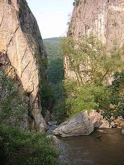 The Erma Gorge, Bulgaria | |
| Native name | Јерма, Ерма |
| Location | |
| Country | Serbia, Bulgaria |
| Physical characteristics | |
| Source | |
| ⁃ location | near Lake Vlasina, Serbia |
| Mouth | |
⁃ location | Nišava near Pirot, Serbia |
⁃ coordinates | 43°4′0″N 22°41′7″E |
| Length | 72 km (45 mi)[1] |
| Basin features | |
| Progression | Nišava→ South Morava→ Great Morava→ Danube→ Black Sea |
Course
Serbia
The Jerma originates in the undeveloped and sparsely populated area of Krajište, in the southeastern corner of Serbia. Starting from the area between the artificial Lake Vlasina and the Bulgarian border, it flows to the northwest on the eastern slopes of the Gramada mountain, passing through the village of Klisura, after which it enters the area of Знепоље (Znepolje, Bulgarian: Знеполе, Znepole), an arid region stretching over the border into Bulgaria. This is where the Jerma crosses the border for the first time, at the border crossing of Strezimirovci.


Bulgaria
Continuing through the Bulgarian part of Znepole curving around the eastern side of the Ruy mountain, the river, now called Erma, is also known as Transka reka after the town of Tran, a regional centre of this area. The Erma passes close to the villages of Glavanovtsi and Turokovtsi, where it turns north, running through Tran. After Tran, the Erma cut the famous gorge Transko zhdrelo ("Gorge of Tran"). After the gorge, Erma flows through the Bulgarian part of the village of Petačinci. Erma receives its major tributary, the Yablanitsa, right before it re-enters Serbia after a 26 km travel through Bulgaria. The river crosses the border for the second time about a kilometer after Petachinci.
Returning to Serbia
The Jerma continues to flow generally to the north, passing next to the village of Iskrovci and the picturesque spa of Zvonačka Banja. Proceeding between the mountains of Greben and Vlaška planina, it runs close to the villages of Trnsko-Odorovce and Vlasi, and the monasteries of Sveti Jovan, Sveti Nikolaj and Sveta Bogorodica, before it empties into the Nišava River, southeast of Pirot after a total of 48 km in Serbia (thus belonging to the Black Sea drainage area). In this last section, the Jerma flows through the Sukovo coal basin, named after the village Sukovo, which is not on the banks of the Jerma itself, but slightly to the west. Despite the hard coal's high quality (7,000 cal), the coal mine near Pirot was shut down and coal is not being extracted any more. In this final section, the Jerma is also known as Sukovska reka (Cyrillic: Суковска река; "river of Sukovo").
References
| Wikimedia Commons has media related to Erma (Jerma River). |
- Statistical Yearbook of the Republic of Serbia 2017 (PDF) (in Serbian and English). Belgrade: Statistical Office of the Republic of Serbia. October 2017. p. 16. ISSN 0354-4206. Retrieved 30 May 2018.
- Mala Prosvetina Enciklopedija, Third edition (1985); Prosveta; ISBN 86-07-00001-2
- Jovan Đ. Marković (1990): Enciklopedijski geografski leksikon Jugoslavije; Svjetlost-Sarajevo; ISBN 86-01-02651-6