Issiglio
Issiglio is a comune (municipality) in the Metropolitan City of Turin in the Italian region Piedmont, located about 45 kilometres (28 mi) north of Turin.
Issiglio | |
|---|---|
| Comune di Issiglio | |
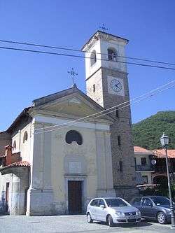 Parish church. | |
Location of Issiglio 
| |
 Issiglio Location of Issiglio in Italy 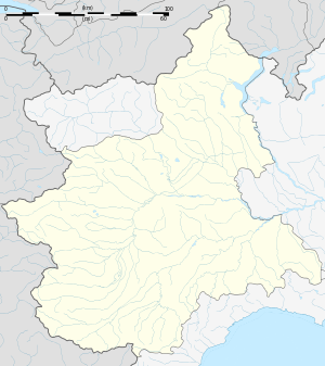 Issiglio Issiglio (Piedmont) | |
| Coordinates: 45°27′N 7°45′E | |
| Country | Italy |
| Region | Piedmont |
| Metropolitan city | Turin (TO) |
| Government | |
| • Mayor | Antonio Oberto Petto |
| Area | |
| • Total | 5.6 km2 (2.2 sq mi) |
| Elevation | 485 m (1,591 ft) |
| Population | |
| • Total | 422 |
| • Density | 75/km2 (200/sq mi) |
| Demonym(s) | Issigliesi |
| Time zone | UTC+1 (CET) |
| • Summer (DST) | UTC+2 (CEST) |
| Postal code | 10080 |
| Dialing code | 0125 |
Issiglio borders the following municipalities: Castellamonte, Alice Superiore, Rueglio, Vistrorio, and Vidracco.
History
The most reliable researcher in the history of Canavese is certainly the Bertolotti who in the second half of the nineteenth century wrote that the current name of Issiglio does not have a sure origin, but there are more versions. A first version wants to derive from the ancient pagan cult that was celebrated in a small temple of the country dedicated to a goddess protector of the countryside: it is not known, however, whether it was the goddess Isis or Isi, deity received from Egypt or the nereide Isea or the goddess Isis, protector of wool mills. This temple was later transformed into a church and was a parish for the towns of Issiglio and Vidracco up to 1693 and still exists near the cemetery.
A second version wants him to derive from In Exilio for being the place of deportation of Roman prisoners who had to work in the mines of the Valley. A third version holds that it derives from Isily, from the Gallic Isiliacum, used to mean place along running waters.
Certain historical facts are known only towards the end of the 1300s: the Village is mentioned in the toll exemptions for the Val di Chy, (which included all the countries of the orographic right of Chiusella) and in the documents of the various feudal lords who owned it. the San Martino di Strambino, the Arundello, the Parella, the Loranzè, the San Martino di Agliè and the Bishops of Ivrea. Until the end of the nineteenth century the village was not served by driveways, it communicated only through paths with Rueglio, Muriaglio, Vidracco and Vistrorio, which was the chief mandate of all the villages of the Bassa Valle starting from Rueglio, and that was only reachable through a walkway of wooden planks laid on the stones of the Chiusella torrent in the border area between Vistrorio and Gauna and then with the
In the second half of the nineteenth century the inhabitants were 775 distributed in less than 200 families. The lower part of the town was in ancient times certainly flooded: from this was born the legend that tells then that the country was much higher, near the current Sardus village and that on the opposite bank the Prince of Arundello fell in love with a poor peasant Issigliese. He managed to drain the lake to win his mother's opposition to the wedding.
The ancient economy of the country was based on breeding, agriculture and craft trades. With the forestation, in addition to solving the problem of heating, it was provided to the dwelling and furnishings. The houses were almost exclusively built of wood and stone, which were raw materials that were found on site. There is also evidence of the existence of two lime kilns and one of bricks, as in the absence of roads external supplies were quite difficult. The houses stood on the territory wherever there was the slightest possibility of agricultural activities, since they had to be adjusted with what was available. Often the craft became so refined up to be a real art as evidenced by some still existing architectural features, for example,
A similar symbiosis between practical functionality and aesthetic peculiarity can also be found in stone arches and, in some less modernized buildings, in brick or wooden ceilings.[4]
Nature and Landscape of Issiglio
Visit to the ancient aqueduct
Until the 1960s, the town of Issiglio had no drinking water in the houses, but was only equipped with five drinking fountains, three of which with a watering hole for livestock. The water came from a derivation of the Savenca torrent with an open-air conduit with discharge openings on its path to divert it into the torrent if necessary, such as work on the pipeline or on the loading tank or with earthy residues following thunderstorms. The first section of the pipeline was occasionally filled with coal, which was used for filtering-water litteration. The loading tank or reservoir placed at an altitude that could serve all the fountains located in the concentric with very little descent and therefore with little pressure was buried in the ground with overlying building,
The vaulted building with full bricks is of all merit, as was the iron access door that was stolen. Of this aqueduct (which went into disuse with the arrival of the present at the beginning of the Sixties), the date of its construction is unknown, even the older ones remember it already existing since their youth, for which it is only possible to hypothesize that was done in the second half of the nineteenth century. The distance to be covered is about one kilometer on an easy and flat path consisting of a dirt road that only narrows along the path. The departure is from the junction between Via Marconi and Via Sale and continues between the narrow of two old villas. The mountain rock dominates the villas on the left and our road, even if an impervious stony path attacks it departing to reach the reservoir tanks of the current aqueduct whose water comes from two sides. From the right comes the withdrawal of the sources that feed the consortium of the six municipalities of the Lower Valchiusella: Rueglio, Alice, Pecco, Lugnacco, Vistrorio and Issiglio located in the area of Bossola and called Fiaut, Cassa, Marciana and Rosone, of which only the last one is on the south side while the other ones are on the north side. A branch of this aqueduct of part in proximity of the old Bridge of Rueglio and through the Lavesso hill and our region Sendola passing the Savenca along a shoulder of the bridge with round trip through the road we cross, and up the mountain up to the two pools that overlook us at an altitude just under six hundred meters, serving as a reserve for the distribution of drinking to the concentric and suburban villages. The other arrival channel has arisen with two purposes; the first is due to the lack of supply of the consortium of the aqueduct, both for errors in assessing the flow rates of the sources and for the increase in consumption. Second motivation is to serve the population spread on the ridge towards Castelnuovo Nigra, resident at an altitude above the loading tanks. consortium aqueduct, both for errors in the assessment of the flow rates of the sources and for the increase in consumption. Second motivation is to serve the population spread on the ridge towards Castelnuovo Nigra, resident at an altitude above the loading tanks. consortium aqueduct, both for errors in the assessment of the flow rates of the sources and for the increase in consumption. Second motivation is to serve the population spread on the ridge towards Castelnuovo Nigra, resident at an altitude above the loading tanks.
This last aqueduct, built solely for the service of our territory, collects the small springs of our municipal assets: Moia Rotonda, Cère and Flussa plus the Sorgenti Cercer in the municipality of Castelnuovo Nigra. In addition to serving almost all of our high hamlets and scattered farmhouses it covers most of all the needs of our country. Leaving aside the news of our current aqueduct, we continue our journey by observing on the right the course of our stream that we will follow in parallel, only separated in this first stretch from the irrigation channel that flows lower down. Beyond the Savenca we see our plain of Sendola - now full of new houses built among the old farmsteads-, whose inhabitants cultivated it in the past and still today in gardens and orchards still has the best meadows of the village and is the base of the Lavesso hill, on which there are some houses, is now abandoned and the wooded carpet expands increasingly. Only its tip (which we call the Mèc or Monte Sinai and the Ruegliesi to which it belongs, the Urget), is still kept alive, even if for some time the friars who were said to have built the housing complex surrounded by a great wall of dry stone, which remains intact. Further on we come to the confluence of the Rio Madone with the Savenca that descends rather steeply with pleasant little waterfalls. Then the small and flat collection of the Stantera which presents a curiosity of borders between municipalities,
Meanwhile, we have reached the tank of the old aqueduct and we can observe its width for the rise of the ground with the small building still intact over time with the special vault and in the center the hatch with the circular stone lid, we can still see the traces of the old adduction channel.
The gold mine
Still starting from the building of the ancient aqueduct, we now return to the "old" paths of Valfosca. Here a draft of auriferous extraction of some veins was attempted. The path that connects us is as short as it is steep. It worked a couple of years between 1876 and 1877 with unsatisfactory economic results. We are fortunate enough to have a copy of the payroll of the workers at the time. We can not say instead of the length of the gallery because it does not appear that someone has had the courage to inspect it. However, seeing its entrance, one can understand that the attempt to search for the precious metal was done at least on two levels before abandoning it. The workers hired for the realization of this activities ranged from 10 to 14 managed by an assistant who was paid monthly with a pay of 100 pounds, those of the workers did not exceed 1 - 2 lire pro die. The dealer of the mine was a certain Bertino di Settimo Tavagnasco. This is the tangible evidence that the valley of the Savenca has various mineral qualitiDes, already noted by the Romans.[5]
The Church of San Pietro
The church was built around the year one thousand, as attested by the antiquity of its architecture, the Romanesque apse decorated with hanging arches, partly concealed today by a funeral construction built next to the building. Until 1696 it was also a parish church for the nearby municipality of Vidracco. With the separation of the two parishes, it was decided to build a new church in Issiglio that preserved the dedication to Saint Peter in bonds. Since then the church has maintained only the function of cemetery chapel.
The church is a single room, with an apse facing east, covered by a trussed roof, left in a state of great decay for many years, has recently been restored with the complete rebuilding of the roof and the restoration of the load-bearing walls.
An unprecedented cycle of fifteenth century Gothic frescoes has been discovered in the church since 2008.[6]
Description of the Church Site
The cycle of AFFRESCHI is large and of a certain iconographic complexity, even if for some parts it is not in good conditions and with large areas of lack. The affected portions are apse, triumphal arch and attached walls, and the right side of the church. The triumphal arch is painted in alternating gray and red segments and surrounded by a decorative motif that recalls bird plumage and which contains the frescoed parts; in the side walls, one on each side, the figures of the angel and the Madonna: the latter, better preserved, with hands on the chest, is reached by the dove of the Holy Spirit above rays of light, while reading, laid on an inclined plane, the book of Isaiah. At the center of the arch, within another decorated cornice, no longer visible due to falling plaster, perhaps a head of the Eternal Father. In the lower registers of the walls, on the left the fresco is almost illegible, on the right is a figure of a blessing bishop, probably of San Dionigi; there, at the top, a curious little black image of a devil. The intrados of the apse arch houses, within shielded frames, a series of portraits, only partially visible, but very expressive, in fifteenth-century dresses, probably prophets and sibyls; the basin shows pictorial fragments that can be interpreted as the symbols of the four Evangelists (Tetramorfo), in a rough rocky landscape, and in the center a lacunose Maiestas Domini. On the left a kneeling female figure, probably still a Virgin, and on the right a fragment of a figure. In the lower part, in the center, the wood of the cross with the canonical inscription, which could be the background of a Pietà. The portion still below carries the traces of the apostles placed in a semicircle, and is partly still hidden by the altar placed there in the following centuries. In the side wall of the hall it is visible, always within a large decorative frame of the same shape as that of the triumphal arch, a large scene, depicting a Madonna of Mercy with the mantle supported by two angels: under the mantle, in two registers superimposed, there are many characters, left male and female right. The two upper ranks house saints and saints, the lower ones pope, cardinal, lords, men and women religious, that is to say the representatives of the earthly hierarchies. Remarkable iconographic peculiarity is the fact that the Virgin of Mercy is depicted on a throne, with the Child in his arms and that the two registers depict dead figures and, below, alive, but with a skull at the center to indicate the transience of life. On the left of this scene is still visible the image of St. Peter bishop, owner of the building, sitting on a bench and with the attribute of the keys.[6]
It is a cycle of considerable stylistic level and of great interest, also iconographic, with overabundance of elegant cartouches, sometimes furnished with a colored initial. Substantial are still the stylistic and thematic references to the world of Jaquerian frescoes with other aspects that recall certain visible developments in the Novarese painting, as shown by the general structure and certain details such as the seated Virgin, with a polygonal perspective base (cycles of Novara or Casalvolone). But the most direct stylistic reference is with the cycle discovered in the summer of 2007 in the parish church of San Giovanni di Torre Canavese. The cycle that seems possible, at least temporarily, to date to the second half of the fifteenth century, after that of Torre, that the interpretation of a writing is still fragmentary.[6]
References
- "Superficie di Comuni Province e Regioni italiane al 9 ottobre 2011". Istat. Retrieved 16 March 2019.
- All demographics and other statistics: Italian statistical institute Istat.
- Istat, Wikidata Q214195
- "Storia e cultura - Associazione Culturale Issigliese Onlus - Museo Vita Alpina di Issiglio". sites.google.com. Retrieved 2019-02-17.
- "Natura e Paesaggio - Associazione Culturale Issigliese Onlus - Museo Vita Alpina di Issiglio". sites.google.com. Retrieved 2019-02-17.
- "Issiglio (TO) : chiesa di San Pietro". Archeocarta (in Italian). 2014-11-18. Retrieved 2019-02-17.