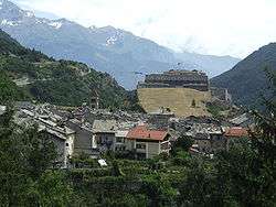
Exilles
Exilles (Occitan: Exilhas, local Occitan: Isiya,[3] Piedmontese: Isiles, Latin: Scingomagus,[4] Italianization under Italian Fascism: Esille) is a comune (municipality) in the Metropolitan City of Turin in the Italian region Piedmont, located about 60 kilometres (37 mi) west of Turin, on the border with France.
Exilles | |
|---|---|
| Comune di Exilles | |
 | |
Location of Exilles 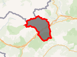
| |
 Exilles Location of Exilles in Italy 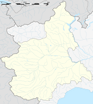 Exilles Exilles (Piedmont) | |
| Coordinates: 45°6′N 6°56′E | |
| Country | Italy |
| Region | Piedmont |
| Metropolitan city | Turin (TO) |
| Frazioni | Deveys, Morliere, San Colombano, Champbons |
| Government | |
| • Mayor | Michelangelo Luigi Castellano |
| Area | |
| • Total | 46.55 km2 (17.97 sq mi) |
| Elevation | 870 m (2,850 ft) |
| Population (1-1-2017)[2] | |
| • Total | 268 |
| • Density | 5.8/km2 (15/sq mi) |
| Demonym(s) | Esillese(i) or Exillese(i) |
| Time zone | UTC+1 (CET) |
| • Summer (DST) | UTC+2 (CEST) |
| Postal code | 10050 |
| Dialing code | 0122 |
| Patron saint | Saint Peter |
| Saint day | June 29 |
| Website | Official website |
It is the location of the Exilles Fort, an alpine fortification which guarded the route between the Kingdom of France and the Duchy of Savoy.
Exilles borders the following municipalities: Bardonecchia, Bramans (France), Chiomonte, Giaglione, Oulx, Pragelato, Salbertrand, and Usseaux.
History
The ancients considered Exilles the first place in Italy coming from Gaul over the Alpine passes. As Scingomagus (Ancient Greek: Σκιγγόμαγος), Exilles is first mentioned by Strabo,[5] who, when speaking of one of the passes of the Alps, says that from Ebrodunum (modern Embrun) on the Gallic side through Brigantium (modern Briançon) and Scingomagus and the pass of the Alps to Ocelum, the limit of the land of Cottius (the Alpes Cottiae) is 159 kilometres (99 mi); and at Scingomagus Italy begins, the distance from Scincomagus to Ocelum being 43 kilometres (27 mi). Pliny the Elder also makes Italy extend to the Alps at Scingomagus, and then he gives the breadth of Gallia from Scingomagus to the Pyrenees and Illiberis.
References
- "Superficie di Comuni Province e Regioni italiane al 9 ottobre 2011". Istat. Retrieved 16 March 2019.
- All demographics and other statistics: Italian statistical institute Istat.
- As seen on the entrance road sign (cf. Google Street View)
- Richard Talbert, Barrington Atlas of the Greek and Roman World, (ISBN 0-691-03169-X), Map 17.
- iv.
Sources

External links