Phayao
Phayao (Thai pronunciation: [pʰā.jāw]) is a town (thesaban mueang) in northern Thailand, capital of Phayao Province. The town is divided into the sub-districts of Mae Tam and Wiang, tambon of Mueang Phayao District.
Phayao พะเยา | |
|---|---|
Town | |
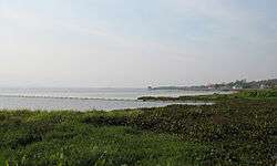 Phayao Lake | |
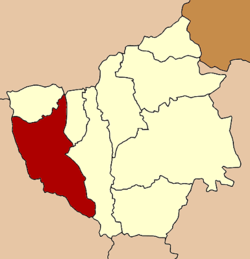 Location in Phayao Province | |
| Country | Thailand |
| Province | Phayao Province |
| Population (2005) | |
| • Total | 19,118 |
| Time zone | UTC+7 (ICT) |
| Area code(s) | 54 |

View of Phayao Lake
The town is on the shore of the Phayao Lake.[1] It dates back to the semi-independent city-state (mueang), founded between 900–1,000 years ago.[1]
As of 2005 Phayao had a population of 19,118. Phayao lies 726 km north of Bangkok.[2]
Climate
| Climate data for Phayao (1981–2010) | |||||||||||||
|---|---|---|---|---|---|---|---|---|---|---|---|---|---|
| Month | Jan | Feb | Mar | Apr | May | Jun | Jul | Aug | Sep | Oct | Nov | Dec | Year |
| Record high °C (°F) | 34.3 (93.7) |
37.1 (98.8) |
39.7 (103.5) |
42.0 (107.6) |
40.7 (105.3) |
40.0 (104.0) |
37.2 (99.0) |
35.6 (96.1) |
35.2 (95.4) |
36.1 (97.0) |
34.6 (94.3) |
33.6 (92.5) |
42.0 (107.6) |
| Average high °C (°F) | 29.3 (84.7) |
32.2 (90.0) |
35.0 (95.0) |
36.0 (96.8) |
33.5 (92.3) |
32.4 (90.3) |
31.6 (88.9) |
31.3 (88.3) |
31.4 (88.5) |
30.7 (87.3) |
29.2 (84.6) |
27.8 (82.0) |
31.7 (89.1) |
| Daily mean °C (°F) | 20.6 (69.1) |
22.8 (73.0) |
26.4 (79.5) |
28.7 (83.7) |
27.8 (82.0) |
27.6 (81.7) |
27.0 (80.6) |
26.7 (80.1) |
26.3 (79.3) |
25.3 (77.5) |
22.7 (72.9) |
20.0 (68.0) |
25.2 (77.4) |
| Average low °C (°F) | 13.7 (56.7) |
15.4 (59.7) |
19.5 (67.1) |
22.9 (73.2) |
23.6 (74.5) |
24.0 (75.2) |
23.7 (74.7) |
23.5 (74.3) |
23.0 (73.4) |
21.7 (71.1) |
18.0 (64.4) |
14.0 (57.2) |
20.2 (68.4) |
| Record low °C (°F) | 6.0 (42.8) |
7.0 (44.6) |
8.5 (47.3) |
16.0 (60.8) |
17.0 (62.6) |
21.3 (70.3) |
20.6 (69.1) |
20.6 (69.1) |
18.7 (65.7) |
12.6 (54.7) |
6.9 (44.4) |
2.5 (36.5) |
2.5 (36.5) |
| Average rainfall mm (inches) | 5.7 (0.22) |
9.2 (0.36) |
30.2 (1.19) |
89.2 (3.51) |
179.7 (7.07) |
102.8 (4.05) |
141.8 (5.58) |
204.0 (8.03) |
203.6 (8.02) |
122.6 (4.83) |
37.3 (1.47) |
10.9 (0.43) |
1,137 (44.76) |
| Average rainy days | 1.2 | 1.6 | 3.2 | 8.6 | 15.5 | 15.3 | 17.7 | 19.4 | 17.0 | 11.4 | 4.2 | 1.4 | 116.5 |
| Average relative humidity (%) | 75 | 66 | 58 | 62 | 74 | 78 | 80 | 83 | 84 | 84 | 81 | 79 | 75 |
| Mean monthly sunshine hours | 272.8 | 257.1 | 275.9 | 243.0 | 198.4 | 117.0 | 120.9 | 117.8 | 144.0 | 179.8 | 216.0 | 251.1 | 2,393.8 |
| Mean daily sunshine hours | 8.8 | 9.1 | 8.9 | 8.1 | 6.4 | 3.9 | 3.9 | 3.8 | 4.8 | 5.8 | 7.2 | 8.1 | 6.6 |
| Source 1: Thai Meteorological Department[3] | |||||||||||||
| Source 2: Office of Water Management and Hydrology, Royal Irrigation Department (sun and humidity)[4] | |||||||||||||
References
- "Phayao". Tourism Authority of Thailand (TAT). Retrieved 18 May 2015.
- "Distance phayao bangkok". Google Maps. Retrieved 18 May 2015.
- "Climatological Data for the Period 1981–2010". Thai Meteorological Department. p. 2. Retrieved 31 July 2016.
- "ปริมาณการใช้น้ำของพืชอ้างอิงโดยวิธีของ Penman Monteith (Reference Crop Evapotranspiration by Penman Monteith)" (PDF) (in Thai). Office of Water Management and Hydrology, Royal Irrigation Department. p. 13. Retrieved 31 July 2016.
External links

This article is issued from Wikipedia. The text is licensed under Creative Commons - Attribution - Sharealike. Additional terms may apply for the media files.