Interstate 294
Interstate 294 (I-294) is a tolled auxiliary Interstate Highway in northeastern Illinois. It forms the southern portion of the Tri-State Tollway in Illinois. I-294 runs from South Holland at I-80/I-94, and Illinois Route 394 (IL 394) to Northbrook at I-94. I-294 is 53.42 miles (85.97 km) long; 5.32 miles (8.56 km) are shared with I-80.[1] It serves as a bypass around the city of Chicago. I-294 is also the longest auxiliary route of I-94, at 10 miles (16 km) longer than I-494 in Minneapolis–Saint Paul. In addition the tollway is the longest auxiliary Interstate Highway in Illinois.
| ||||
|---|---|---|---|---|
| Tri-State Tollway | ||||
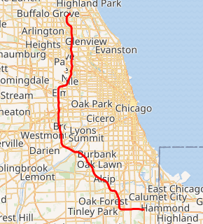
I-294 highlighted in red | ||||
| Route information | ||||
| Auxiliary route of I-94 | ||||
| Maintained by ISTHA | ||||
| Length | 53.45 mi[1] (86.02 km) | |||
| Existed | 1957–present | |||
| History | Completed 1968 | |||
| Major junctions | ||||
| South end | ||||
| ||||
| North end | ||||
| Location | ||||
| Counties | Cook | |||
| Highway system | ||||
| ||||

Route description
I-294 has four of the Tri-State Tollway's six mainline barriers. These are located at:
- 163rd Street
- 82nd Street (southbound) and 83rd Street (northbound)
- Cermak Road
- Irving Park Road (IL 19; southbound) and Touhy Avenue (northbound)
The other two barriers are on I-94.
History
The portion of the Borman Expressway that was completed from Gary westward and the Kingery Expressway were originally designated as I-80, I-90, and I-294 from shortly after the Interstate Highway program was enacted until about 1965, when the connection between the Borman and the Indiana Toll Road was completed, and I-90 was swapped with I-94 west of that junction (and east of where those routes share the same road in Chicago), cutting back I-294 to its current south terminus (eliminating the Indiana part of I-294). Indiana later proposed to extend I-294 east on the current Borman Expressway to Indiana State Route 912, before having it turn north at that point, west at U.S. Route 12, and then back to I-94, most likely somewhere on the Bishop Ford Freeway near 130th Street. The request was denied.
I-294 was built largely before the growth and maturation of the suburbs that run along the corridor. As a result, the vast majority of the interchanges are partial, or were configured to have entrance ramps feeding the toll plazas. Gaps between exit ramps are common, the 6.5-mile (10.5 km) gap between Cicero Avenue (IL 50/IL 83) and 95th Street (US 12/US 20) being one of the more notable ones. Partial interchanges are located at Roosevelt Road (IL 38; northbound exit, southbound entrance), Irving Park Road (IL 19) (southbound exit, northbound entrance), Touhy Avenue (northbound exit, southbound entrance), Dempster Street (US 14; northbound exit, southbound entrance), and Golf Road (IL 58; southbound exit, northbound entrance). Several former partial interchanges have been converted to full interchanges, with automated toll collection facilities on the new ramps, such as at 159th Street (US 6; northbound on and southbound off added) and 95th Street (US 12/US 20; southbound on and northbound off added). The 79th Street exit was moved to 75th Street/Willow Springs Road, and made a complete interchange in the same manner.
From 1992-1993, the central portion of Interstate 294 between Interstate 90 and 95th Street was widened to eight lanes.[2] Between 2006-2009, the southern and northern portions of I-294 (IL-394 to 95th Street and I-90 to Lake Cook Road respectively) were fully reconstructed and expanded, bringing the entire highway up to eight lanes.
Move Illinois Program construction
.jpg)
As part of the $12 billion Move Illinois capital program, ISTHA and the Illinois Department of Transportation (IDOT) are partnering to construct a new, all-electronic interchange to connect I-294 to I-57. In 2014, ISTHA completed the primary interchange connections between I-294 and I-57 and at 147th Street. The remaining ramps to complete the interchange will be completed in 2023–24.[3]
Additionally, ISTHA will rebuild the central portion of Interstate 294 between 95th Street and Balmoral Avenue.[4] When this portion of I-294 is rebuilt, it will be widened up to five or six lanes in each direction, get wider shoulders for buses and get active traffic management features that are currently in use on the Jane Addams Memorial Tollway as part of its rebuilding and widening project.[5][6]
Exit list
The entire route is in Cook County.
| Location | mi[1][7] | km | Exit[8] | Destinations | Notes | |
|---|---|---|---|---|---|---|
| Lansing | 0.00 | 0.00 | Southern terminus; southern end of I-80 concurrency; southern end of US 6 concurrency (NB lanes only) | |||
| 161 | Exit number follows I-80; no southbound entrance; northern end of US 6 concurrency (NB lanes only); only free exit northbound | |||||
| Lansing–Thornton Township line | 0 | Southbound exit and northbound entrance; southern terminus of Tri-State Tollway; I-94 exit 74B | ||||
| South Holland | 0.90 | 1.45 | Chicago Southland Lincoln Oasis | |||
| East Hazel Crest | 2.83 | 4.55 | 2 | Signed as exits 2A (north) and 2B (south) | ||
| 4.33 | 6.97 | 4 | Dixie Highway | Southbound exit and northbound entrance | ||
| Hazel Crest | 5.26 | 8.47 | 5 | Northern end of I-80 concurrency; I-80 exit 155 | ||
| 5.81 | 9.35 | 163rd Street Toll Plaza | ||||
| Markham | 6.48 | 10.43 | 6 | Signed as exits 6A (east) and 6B (west) | ||
| Blue Island | 7.75 | 12.47 | 7 | I-Pass only; southbound exit and northbound entrance; full interchange opening 2023–24; I-57 exit 349 | ||
| 8.33 | 13.41 | 8 | I-Pass only; southbound exit and northbound entrance | |||
| Alsip | 12.13 | 19.52 | 12 | Signed as exits 12A (south) and 12B (north) | ||
| Hickory Hills | 17.63 | 28.37 | 17 | Signed as exits 17A (east) and 17B (west) southbound; no northbound signage for 76th Avenue | ||
| 19.37 | 31.17 | 83rd Street Toll Plaza (northbound) | ||||
| 19.78 | 31.83 | 82nd Street Toll Plaza (southbound) | ||||
| Justice | 20.45 | 32.91 | — | Southbound entrance only | ||
| Des Plaines River | 21.20– 21.88 | 34.12– 35.21 | Mile-Long Bridge | |||
| Hodgkins | 22.04– 22.28 | 35.47– 35.86 | 22 | 75th Street / Willow Springs Road (10800 West) | ||
| Indian Head Park | 23.20– 24.24 | 37.34– 39.01 | 23 | Signed as Exit 23A (north) and Exit 23B (south) northbound; no exit number southbound; no southbound entrance from I-55 south. (Access from I-55 South to I-294 South is via US 12-20-45 La Grange Rd. and is signed as such on I-55.); I-55 exit 277; southbound exit and northbound entrance provide access from and to Joliet Road | ||
| 23.42 | 37.69 | 23B | Wolf Road (11200 West) | Northbound exit and southbound entrance | ||
| Hinsdale | 25.13 | 40.44 | Hinsdale Oasis | |||
| Western Springs | 27.57 | 44.37 | 27 | Signed as exits 27A (east) and 27B (west) | ||
| Oak Brook | 29.40 | 47.31 | 29 | Northbound exit and southbound entrance; I-88 exit 138 | ||
| 29.63 | 47.68 | 29 | Cermak Road (22nd Street) | Southbound exit and northbound entrance | ||
| 30.00 | 48.28 | Cermak Road Toll Plaza | ||||
| Hillside | 30.64 | 49.31 | 30 | Northbound exit and southbound entrance; signed as exits 30A (east) and 30B (west) | ||
| 31.15 | 50.13 | 31A | Southbound exit and northbound entrance | |||
| Berkeley | 31.74 | 51.08 | 31B | Signed as exit 31 northbound; I-290 exit 15 | ||
| Elmhurst | 33.76 | 54.33 | 33 | Signed as exit 31 northbound; I-290 exit 13A | ||
| Bensenville | Future interchange | |||||
| Schiller Park | 37.96 | 61.09 | O'Hare Oasis (Gas station only) | |||
| 38.41 | 61.81 | 38 | Southbound exit and northbound entrance; signed as exits 38A (east) and 38B (west) | |||
| 38.89 | 62.59 | Irving Park Toll Plaza (southbound) | ||||
| Rosemont | 39.91 | 64.23 | 39 | Balmoral Avenue | I-Pass only on northbound exit ramp; northbound exit and southbound entrance | |
| 40.42 | 65.05 | 40A | Signed as exit 40 northbound; I-190 exits 1C-D | |||
| 40.88 | 65.79 | 40B | Signed as exit 40 northbound; I-90 exits 77 and 78 | |||
| Park Ridge | 41.64 | 67.01 | Touhy Avenue Toll Plaza (northbound) | |||
| 42.28 | 68.04 | 42 | Touhy Avenue | Northbound exit and southbound entrance; signed as exits 42A (east) and 42B (west) | ||
| Des Plaines | 44.32 | 71.33 | 44 | Northbound exit and southbound entrance; signed as exits 44A (east) and 42B (west) | ||
| 45.34 | 72.97 | 45 | Southbound exit and northbound entrance | |||
| Glenview | 49.02 | 78.89 | 48 | Willow Road | ||
| Northbrook | 52.75 | 84.89 | 52 | Lake Cook Road | Northbound exit and southbound entrance | |
| — | Northern terminus; northbound exit and southbound entrance; I-94 exit 25B | |||||
1.000 mi = 1.609 km; 1.000 km = 0.621 mi
| ||||||
References
- Illinois Technology Transfer Center (2006). "T2 GIS Data". Retrieved November 8, 2007.
- P. Davis Szymczak (September 27, 1991). "Widening of Tri-State could begin in October". Chicago Tribune. Retrieved April 18, 2010.
- Staff. "I-294/I-57 Interchange Fact Sheet". Illinois State Toll Highway Authority. Archived from the original on May 26, 2014. Retrieved May 17, 2014.
- Staff. "Move Illinois: Fact Sheets" (PDF). Illinois State Toll Highway Authority. Archived from the original (PDF) on May 22, 2013. Retrieved September 19, 2014.
- Wronski, Richard. "Tollway to Add 'Smart Highway' Features Too". Chicago Tribune. Retrieved September 19, 2014.
- Wronski, Richard. "Tollway Working on Plan to Rebuild, Maybe Widen, Tri-State". Chicago Tribune. Retrieved December 12, 2014.
- Illinois State Toll Highway Authority. System Map (Map). Downers Grove: Illinois State Toll Highway Authority. Archived from the original on January 24, 2009. Retrieved January 23, 2009.
- "Toll Rates by Plaza (For Years 2009+)" (PDF). Illinois State Toll Highway Authority. Archived from the original (PDF) on January 12, 2009. Retrieved January 23, 2009.
External links
| Wikimedia Commons has media related to Interstate 294. |