Hunsur
Hunsur is a city in Mysore district in the Indian state of Karnataka. It is the headquarters of the Hunsur Taluk administrative division. Hunsur is maintained by the Hunsur City Municipal Council and has a total of 31 wards.


Hunasuru TimberLand | |
|---|---|
City | |
| Nickname(s): GaadiPalya | |
 Hunasuru Location in Karnataka, India  Hunasuru Hunasuru (India) | |
| Coordinates: 12.3105671°N 76.2802055°E | |
| Country | India |
| State | Karnataka |
| District | Mysore |
| Elevation | 792 m (2,598 ft) |
| Population (2020) | |
| • Total | 62,668 |
| Languages | |
| • Official | Kannada |
| Time zone | UTC+5:30 (IST) |
| PIN | 571 105 |
| Telephone code | 08222 |
| Vehicle registration | KA-45( Includes nearby places like K R Nagar,Periyaptna and H D Kote) |
| Website | www |
Geography
Hunsur is located at 12.31°N 76.29°E.[1] Hunsur is situated on the western side of Mysore city on the way to Virajpet town(SH 90). Madikeri (NH-275) also lies on the western side of Hunsur on another road. Hassan (SH 86) lies on the northern side of Hunsur and H.D.Kote town is on the southern side and Mysore on the Eastern side. Hunsur lies on NH-275 and connects Bangalore to the Nagarahole National Park, Madikeri, Kodagu, Mangalore, and Virajpet.
Hunsur has an average elevation of 792 meters (2598 feet). Hunsur city is about 11.76 km2 of the total area. The river Lakshmana Tirtha flows through the town and is crossed by two bridges. The town is the administrative center of Hunsur taluk, which is part of the Mysore District. The average temperature in summer is 28°c. The average temperature in winter is 21°c.
People
Former Chief Minister of Karnataka state Sri D. Devaraj Urs hailed from this constituency. The film director Hunsur Krishnamurthy also hailed from here. H P Manjunath from INC is the current MLA.
Hunsur taluk
The total population of Hunsur Taluk is 253,926 (2001 census) living in 52,437 houses, spread across total 323 villages and 31 panchayats. There were 129,409 males and 124,517 females. There are 4 hoblis in Hunsur Taluk which are Bilikere, Hanagudu, Gavadagere and Kasaba. Hunsur Taluk shares a border with Kodagu district to the south west.
Economy
Hunsur is well known for the timber trade, especially teak. Hunsply, a plywood manufacturing company, is located in Hunsur. Hunsur teak is noted for its quality and durability. Another important trade activity is tobacco growing and tobacco auctions.There is a tobacco board in Kattemalalavadi which is 5 km from the city. Consolidated Coffee Curing Works employs many people in coffee bean processing. This location is also a growing market for sheep farming. Farmland surrounds the town, and there is a government owned milk decimation centre in the city.
Education
Schools
- Adarsha vidyalaya
- Shastry public school
- St Joseph's central school
- Talent public school
- New Cambridge public school
- Takshashila public school
- Holy Family public school
- Christ school
- Rotary school
- Adullam convent
- Central school for Tibetan
- Icon International residential school
Colleges
- D Devaraj Arasu degree college
- Chayadevi group of institutions
- Gnanadhara degree college
- St. Joseph's degree college
- Government degree college (women)
- Government degree college (men)
- Vikram paramedical college
Tourism
Nagarahole National Park is about 40 km located in Hunsur Taluk, which shares a border with Coorg district.
There is a gaddige kendaganneshwara temple which is about 20 km from Hunsur. Gurupura, a village with Tibetan settlement, is also about 13 km away.
Etymology
This town used to be called 'Gaadi Palya', meaning 'a resting station for bullock carts'. Hunsur is a common place to get settled for all officials who are working in Mysore, as it is only about 45 minutes away from Mysore.
Transport
Hunsur is connected by bus to many cities and towns of Karnataka. It also has bus connectivity to neighbouring states of Kerala and Tamil Nadu. The nearest railway station is K R Nagar railway station which is 22 km from Hunsur. The nearest international airports are
- Kannur International Airport (113 km)
- Mangalore international airport (215 km)
- Kempegowda International Airport (217 km).
- Mysore Airport (58 km)
By road, Hunsur city is located 45 km from Mysore, 185 km from Bangalore. The city passes NH-275, SH-86, SH-90 The mist city Madikeri is about 70 km, Virajpete town is 55 km.
Politics and administration
The city is administered by Hunsur CMC with the total number of 31 wards. Hunsur is a subdivision of Mysore district, hence major government offices are located here.{{fact} } Central tobacco research institute (CTRI), Hunsur wildlife region office are also located in the city. Hunsur has its own RTO office (KA-45) which also includes neighbouring towns.
H P Manjunath from INC is the current MLA.
Languages
Kannada is the predominant and widely spoken language in Hunsur. English and Kannada are used as a medium of instruction in the schools and colleges.
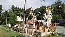
Temples
There is a hilltop ayyappa Swamy temple in the city, and another hilltop Omkareswara temple about 4 km from the city at Ramenahalli.
Of the other many temples, churches and mosque located here, examples include the famous Sai Baba mandira and mooruramma temple.
Infrastructure
The city has a number of amenities, which include a shopping complex, super markets, shopping malls, snacks and juice corners, stadium, municipality swimming pool and many number of parks in each area. Hunsur city has two Karnataka State Road Transport Corporation (KSRTC) bus stations and a KSRTC bus depot, fire brigade, hospitals and health care are also located in the city.
Demographics
As of 2011 India census,[2] Hunsur had a population of 62668(2020). Males constitute 51% of the population and females 49%. 12% of the population is under six years of age.Hunsur has an average literacy rate of 69%, higher than the national average of 59.5%: male literacy is 74%, and female literacy is 63%.
See also
References
| Wikimedia Commons has media related to Hunsur. |
- Falling Rain Genomics, Inc - Hunsur
- "Census of India 2020: Data from the 2020 Census, including cities, villages and towns (Provisional)". Census Commission of India. Archived from the original on 16 June 2004. Retrieved 1 November 2008.