Huehuetenango
Huehuetenango ([weweteˈnanɡo]) is a city and municipality in the highlands of western Guatemala. It is also the capital of the department of Huehuetenango. The city is situated 269 kilometres (167 mi) from Guatemala City, and is the last departmental capital on the Pan-American Highway before the Mexican border at La Mesilla.
Huehuetenango Xinabahul | |
|---|---|
Municipality | |
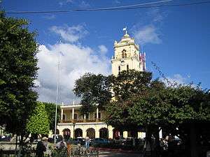 The city center of Huehuetenango | |
| Nickname(s): Huehue | |
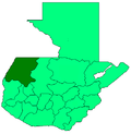
 Huehuetenango Location in Guatemala | |
| Coordinates: 15°18′53″N 91°28′34″W | |
| Country | |
| Department | |
| Municipality | Huehuetenango |
| Government | |
| • Mayor | GERONIMO MARTINEZ[1] (LIDER) |
| Area | |
| • Municipality | 222 km2 (86 sq mi) |
| Elevation | 1,901 m (6,237 ft) |
| Population (census 2018)[2] | |
| • Municipality | 117,818 |
| • Density | 530/km2 (1,400/sq mi) |
| • Urban | 117,818 |
| • Ethnicities | Mam, Ladino |
| • Religions | Roman Catholicism, Evangelicalism, Maya |
| Climate | Cwb |
Overview
Huehuetenango (originally called Xinabajul in the Mam language) was already a Mayan settlement before the Spanish conquest of the fortified city of Zaculeu, which was the Pre-Columbian capital of the Mam kingdom situated just a few kilometers from Xinabahul. 'Huehuetenango' means place of the ancients (or ancestors) in Nahuatl, which is the name Gonzalo de Alvarado adopted from his Nahua allies when Zaculeu and Xinabahul were conquered.
Many people of Mam descent still live in and around Huehuetenango, and the nearby ruins of Zaculeu have become a tourist attraction. The ruins are markedly distinct from other Mayan archeological sites; the original unearthed stones, comprising only a small portion of the original structures, were coated with plaster during restoration works carried out in the 1940s. There is also a small museum at Zaculeu that includes statues and small artifacts found on the site.
Huehuetenango's primary export is coffee.
Huehuetenango Airport (IATA: HUG , ICAO: MGHT ) is within the city and has a paved 825 metres (2,707 ft) runway and a small terminal building. There are currently no scheduled airline flights.[4]
Climate
The city has a subtropical highland climate (Köppen: Cwb), with warm summers and mild winters.[5]
| Climate data for Huehuetenango | |||||||||||||
|---|---|---|---|---|---|---|---|---|---|---|---|---|---|
| Month | Jan | Feb | Mar | Apr | May | Jun | Jul | Aug | Sep | Oct | Nov | Dec | Year |
| Average high °C (°F) | 21.6 (70.9) |
23.0 (73.4) |
25.1 (77.2) |
25.7 (78.3) |
25.1 (77.2) |
23.5 (74.3) |
23.2 (73.8) |
23.8 (74.8) |
23.3 (73.9) |
22.5 (72.5) |
22.0 (71.6) |
21.8 (71.2) |
23.4 (74.1) |
| Daily mean °C (°F) | 14.9 (58.8) |
15.8 (60.4) |
17.7 (63.9) |
18.6 (65.5) |
18.8 (65.8) |
18.1 (64.6) |
17.6 (63.7) |
17.7 (63.9) |
17.6 (63.7) |
17.0 (62.6) |
15.9 (60.6) |
15.0 (59.0) |
17.1 (62.7) |
| Average low °C (°F) | 8.3 (46.9) |
8.6 (47.5) |
10.4 (50.7) |
11.6 (52.9) |
12.6 (54.7) |
12.8 (55.0) |
12.1 (53.8) |
11.6 (52.9) |
11.9 (53.4) |
11.5 (52.7) |
9.8 (49.6) |
8.7 (47.7) |
10.8 (51.5) |
| Average precipitation mm (inches) | 9 (0.4) |
12 (0.5) |
25 (1.0) |
46 (1.8) |
120 (4.7) |
228 (9.0) |
134 (5.3) |
140 (5.5) |
229 (9.0) |
156 (6.1) |
37 (1.5) |
11 (0.4) |
1,147 (45.2) |
| Source: Climate-data.org | |||||||||||||
Sports
The city currently boasts one Guatemalan top level football side with Peñarol La Mesilla (Halcones now) in the Liga Nacional de Fútbol de Guatemala.
Notable people
Former president Efraín Ríos Montt was born in Huehuetenango.
Notes
- Resultados de elección de Alcades Huehuetenango realizadas en el año 2015
- Citypopulation.de Population of departments and municipalities in Guatemala
- Citypopulation.de Population of major cities in Guatemala
- "Huehuetenango - Guatemala". World Airport Codes. Retrieved May 1, 2019.
- "Huehuetenango climate: Average Temperature, weather by month, Huehuetenango weather averages - Climate-Data.org". en.climate-data.org. Retrieved 2019-02-15.