Houtkerque
Houtkerque (from Dutch: Houtkerke) is a communes in the Nord department in northern France. It is located near the Belgian border, 8 km (5.0 mi) north of Steenvoorde, on the Steenvoorde/Hondschoote road. The Yser River crosses the border at Houtkerque.
Houtkerque Houtkerke | |
|---|---|
.jpg) Église Saint-Antoine d'Houtkerque | |
_Nord-France.svg.png) Coat of arms | |
Location of Houtkerque 
| |
 Houtkerque  Houtkerque | |
| Coordinates: 50°52′12″N 2°35′46″E | |
| Country | France |
| Region | Hauts-de-France |
| Department | Nord |
| Arrondissement | Dunkirk |
| Canton | Wormhout |
| Intercommunality | Communauté de communes de Flandre Intérieure |
| Government | |
| • Mayor (2014-2020) | Samuel Bever |
| Area 1 | 13.13 km2 (5.07 sq mi) |
| Population (2017-01-01)[1] | 994 |
| • Density | 76/km2 (200/sq mi) |
| Demonym(s) | Houtkerquois |
| Time zone | UTC+01:00 (CET) |
| • Summer (DST) | UTC+02:00 (CEST) |
| INSEE/Postal code | 59318 /59470 |
| Elevation | 2–22 m (6.6–72.2 ft) (avg. 18 m or 59 ft) |
| 1 French Land Register data, which excludes lakes, ponds, glaciers > 1 km2 (0.386 sq mi or 247 acres) and river estuaries. | |
Houtkerque saw much action during World War I. Seven Commonwealth war graves are situated within Houtkerque's church.
 Gravestone
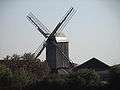 Windmill "Hofland"
.jpg) Mill of Hofland also called mill Accou, Houtkerque, North, France.
Mill of Hofland also called mill Accou, Houtkerque, North, France.
Politics
Presidential Elections 2nd Round
| Election | Winning Candidate | Party | % | |
|---|---|---|---|---|
| 2017 | Marine Le Pen | FN | 53.83 | |
| 2012 | Nicolas Sarkozy | UMP | 59.60 | |
| 2007 | Nicolas Sarkozy | UMP | 62.03 | |
| 2002 | Jacques Chirac | RPR | 77.42 | |
See also
References
- "Populations légales 2017". INSEE. Retrieved 6 January 2020.
- http://www.lemonde.fr/data/france/presidentielle-2017//
| Wikimedia Commons has media related to Houtkerque. |
| Authority control |
|
|---|
This article is issued from Wikipedia. The text is licensed under Creative Commons - Attribution - Sharealike. Additional terms may apply for the media files.