Horní Kamenice (Domažlice District)
Horní Kamenice is a village and municipality (obec) in Domažlice District in the Plzeň Region of the Czech Republic. The municipality covers an area of 3.85 square kilometres (1.49 sq mi), and has a population of 212 (as at 3 July 2006).
Horní Kamenice | |
|---|---|
Municipality | |
 Municipal office and chapel (left) | |
 Flag .svg.png) Coat of arms | |
 Horní Kamenice | |
| Coordinates: 49°33′39″N 13°5′59″E | |
| Country | |
| Region | Plzeň |
| District | Domažlice |
| Area | |
| • Total | 3.85 km2 (1.49 sq mi) |
| Elevation | 377 m (1,237 ft) |
| Population (2006) | |
| • Total | 212 |
| • Density | 55/km2 (140/sq mi) |
| Postal code | 345 62 |
Location
Horní Kamenice is located in the valley of the river Radbuza and west of Wittuna forest. Through the village flows a small river named Srbický potok. Horní Kamenice lies approximately 19 kilometres (12 mi) north-east of Domažlice, 29 km (18 mi) south-west of Plzeň, and 112 km (70 mi) south-west of Prague.
History
The village of Horní Kamenice was first mentioned in 1115.[1]
Buildings
- Chapel
- Ruin of Castle Lacembok (south of village)
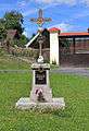 Crucifix in Horní Kamenice
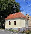 Chapel in Horní Kamenice
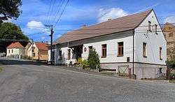
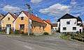 Village view
This article is issued from Wikipedia. The text is licensed under Creative Commons - Attribution - Sharealike. Additional terms may apply for the media files.