Chodská Lhota
Chodská Lhota (until 1946 Lhota, German: Melhut) is a village and municipality (obec) in Domažlice District in the Plzeň Region of the Czech Republic.
Chodská Lhota | |
|---|---|
Municipality | |
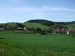 General view of the village | |
 Flag  Coat of arms | |
 Chodská Lhota | |
| Coordinates: 49°20′54″N 13°4′49″E | |
| Country | |
| Region | Plzeň |
| District | Domažlice |
| Area | |
| • Total | 10.27 km2 (3.97 sq mi) |
| Elevation | 500 m (1,600 ft) |
| Population (2011) | |
| • Total | 433 |
| • Density | 42/km2 (110/sq mi) |
| Postal code | 345 10 |
| Website | http://www.chodskalhota.cz |
The municipality covers an area of 10.27 square kilometres (3.97 sq mi), and has a population of 406 (as of 28 August 2006).
Chodská Lhota lies approximately 16 kilometres (10 mi) south-east of Domažlice, 50 km (31 mi) south-west of Plzeň, and 127 km (79 mi) south-west of Prague.
Gallery
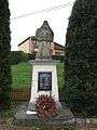 Monument
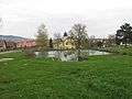 Water tank
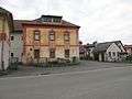 Pub
Pub
This article is issued from Wikipedia. The text is licensed under Creative Commons - Attribution - Sharealike. Additional terms may apply for the media files.