Hoorn
Hoorn [ˈɦoːr(ə)n] (![]()
Hoorn, Netherlands | |
|---|---|
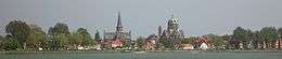      .jpg) From top down, left to right: skyline of Hoorn; Halve Maen; West-Frisian Museum, Roode Steen square; Hoofdtoren, Hoorn Central Station, city canal | |
 Flag | |
.svg.png) Location in North Holland | |
| Coordinates: 52°39′12″N 05°04′24″E | |
| Country | Netherlands |
| Province | North Holland |
| Government | |
| • Body | Municipal council |
| • Mayor | Jan Nieuwenburg (PvdA) |
| Area | |
| • Total | 53.25 km2 (20.56 sq mi) |
| • Land | 20.25 km2 (7.82 sq mi) |
| • Water | 33.00 km2 (12.74 sq mi) |
| Elevation | −1 m (−3 ft) |
| Population (January 2019)[4] | |
| • Total | 73,004 |
| • Density | 3,605/km2 (9,340/sq mi) |
| Demonym(s) | Horinees |
| Time zone | UTC+1 (CET) |
| • Summer (DST) | UTC+2 (CEST) |
| Postcode | 1620–1628, 1689, 1695 |
| Area code | 0229 |
| Website | www |
Cape Horn, the most southerly point of the Americas, was named after the town by Willem Schouten, who navigated the cape in 1616.
The Hoorn Islands of the French overseas collectivity of Wallis and Futuna in Oceania are also named after this city.
Etymology
The origin of the name Hoorn, even in old spelling Hoern(e) or Hoirne, is surrounded in myths. Hoorn's name, according to Old Frisian legends, is derived from the stepson of King Redbad (Radboud), called Hornus. Another story about the origin of the name is that it is derived from a sign depicting a post horn in an early 14th-century hanging outside one of the establishments situated on the Roode Steen Square. A third version says that the name was derived from the horn shape of one of its first ports. The author of the 'Origo Civitatis Hornensis' (see page. 256, 'Uit de schemer van Hoorns verleden') assumes that name Hoorn was derived from Damphoorn. Damphoorn is the medieval name for a weed that could be made into whistles, which grew in abundance in the area outside the dykes of Hoorn. Chronicler Velius rejects this statement because there are no old historical entries that Hoorn was called Damphoorn. He wrote: The name was from the start Hoorn: not (against better judgement) derived from the weed Damphoorn, as the current sentiment holds (De name was van eersten af Hoorn: niet (behoudens beter oordeel) van het kruyt Damphoorn, als t'ghemeyne ghevoelen van noch heden hout). Velius also rejects the assertion that the name's origin is Dampter Horn: a neighbourhood of the village Dampten, which flooded and had fallen into disuse.
The name is most probably derived from Hornicwed, a name that is popping up in early mediaeval documents. The medieval meaning of hornic is 'corner', with wed or wedor being the medieval word for water. Many places and neighbourhoods in the Netherlands are called, even today, Heurne, Huurne and Horn. Hornicwed would therefore refer to the location of a corner on the coastline: the location of Hoorn at the Zuiderzee. We see hornic in the meaning of 'corner' also reflected in another municipality in the mediaeval County of Holland: Uithoorn, meaning uithoek, which refers to a certain occupied area (or corner) at some distance.
It is also sometimes argued that hornic refers to a corner in a dike, but this raises doubts: the coast of the Zuiderzee was originally farther away from Hoorn compared to the present day: the Westfriese Omringdijk ran, originating from the West, in a straight line to Schardam and in front of this dyke there were then low-lying tracts of land, where the village of Dampten was located according to Velius. This area was abandoned and flooded after 1391, following the abandonment of the old dyke. A new dyke was built farther inland, resulting in a bay which is now the Hoornse Hop. Hoorn was already in existence then.
History
| Historical population | ||
|---|---|---|
| Year | Pop. | ±% p.a. |
| 1398 | 3,800 | — |
| 1514 | 5,400 | +0.30% |
| 1550 | 8,000 | +1.10% |
| 1622 | 14,139 | +0.79% |
| 1632 | 13,500 | −0.46% |
| 1732 | 12,000 | −0.12% |
| 1795 | 9,551 | −0.36% |
| Source: Lourens & Lucassen 1997, pp. 62–63 | ||
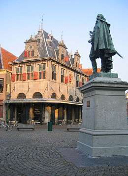
Founded in 716, Hoorn rapidly grew to become a major harbour town. During Holland's 'Golden Age' (or 'Golden Century'), Hoorn was an important home base for the Dutch East India Company (VOC) and a very prosperous centre of trade. The Hoorn fleet plied the seven seas and returned laden with precious commodities. Exotic spices such as pepper, nutmeg, cloves, and mace were sold at vast profits. With their skill in trade and seafaring, sons of Hoorn established the town's name far and wide. Jan Pieterszoon Coen (1587–1629) is famous for his violent raids in Dutch Indies (now Indonesia), where he "founded" the city of Batavia in 1619 (now Jakarta). He has a big statue on the Rode Steen square in the center of Hoorn.
In 1618 Willem Bontekoe (1587–1657) undertook his first and only voyage for the VOC. His story of his travel and hardship found its way into the history books when he published his adventures in 1646 under the title Journael ofte gedenckwaerdige beschrijvinge van de Oost-Indische reyse van Willem Ysbrantsz. Bontekoe van Hoorn, begrijpende veel wonderlijcke en gevaerlijcke saecken hem daer in wedervaren ('Journal, or memorable description, of the East-Indian voyage of Willem Ysbrantz. Bontekoe of Hoorn, comprising many wondrous and dangerous things experienced by him'). In 1616, the explorer Willem Corneliszoon Schouten braved furious storms as he rounded the southernmost tip of South America. He named it Kaap Hoorn (Cape Horn) in honour of his home town.[5]
Hoorn's fortunes declined somewhat in the eighteenth century. The prosperous trading port became little more than a sleepy fishing village on the Zuiderzee. Following Napoleonic occupation, there was a period during which the town gradually turned its back on the sea. It developed to become the market for the entire West Frisian agricultural region. Stallholders and shopkeepers devoted themselves to trading in dairy produce and seeds. When the railway and metalled roads came to Hoorn in the late nineteenth century, the town rapidly took its rightful place as a conveniently located and readily accessible centre in the network of towns and villages which make up the province of Noord-Holland. In 1932, the Afsluitdijk, or Great Enclosing Dyke, was completed, and Hoorn was no longer a seaport.
The years after the Second World War saw a period of renewed growth. At the centre of a flourishing horticultural region, Hoorn developed an extremely varied economy. During the 1960s, Hoorn was designated an 'overflow' city to relieve pressure on the overcrowded Randstad region. Thousands of people swapped their cramped little apartments in Amsterdam for a family house with garden in one of Hoorn's modern new developments.
On 26 March 2007, Hoorn celebrated 650 years as a city: in 1357 Hoorn was awarded city rights by the Count of Holland after a lump sum payment of 1500 schilden to the Count.
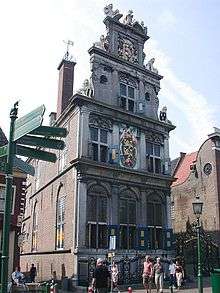
Notable buildings
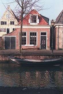
Hoorn has a very high number of surviving 17th and 18th century houses, especially north of the harbour area, adding much to the character of the area. Other notable buildings include:
- The main Protestant church on Kerkplein, converted to shops and community uses in 1997[6] but currently (2018) closed.
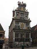
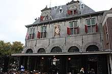
- The Waag (17th-century weigh-house) at the junction of Grote Oost and the main town square
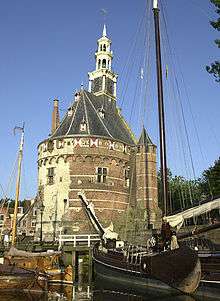
- The 15th-century Hoofdtoren, the old harbour control building
- A very fine line of 17th-century houses and original shop-fronts on the harbour edge at Hoofd
- 'T Wees Huys (1620) on Achterstraat
- The Claes Stapelhof (1682) on the Munnickenveld straat
- Maria or Kruittoren (1508), on the Achter de Vest, built in late gothic style as part of the city wall. Most of the wall has been taken down but this tower still stands.
Hoorn has notable modern buildings as well, for example:
- Schouwburg Het Park, a theatre and congress centre which was opened on 25 June 2004 by Queen Beatrix (since 2013 Princess Beatrix). They started building the theatre in 2000 but due to faulty construction work a part of the theatre (which was not yet finished) came crashing down in the night of 20 April 2001.
Neighbourhoods
Hoorn contains 13 neighbourhoods:
- Binnenstad
- Venenlaankwartier
- Hoorn-Noord
- Grote Waal
- Risdam-Zuid
- Risdam-Noord
- Nieuwe Steen
- Zwaag
- Westerblokker
- Kersenboogerd-Noord
- Kersenboogerd-Zuid
- Hoorn 80
- Bangert en Oosterpolder
Museums
- Museumstoomtram Hoorn-Medemblik
- Westfries Museum
- Museum van de 20e Eeuw on Oostereiland
Local government
The municipal council of Hoorn consists of 35 seats, which are divided as follows:
Railway connections
Hoorn is connected to the Dutch railway network, and has two stations: Hoorn and Hoorn Kersenboogerd. Also, it is the starting point of the historical railway between Hoorn and Medemblik.
Notable people
Born
This is a non-exhaustive list of notable people from Hoorn:
Public thinking & Public Service
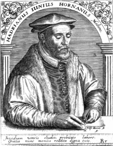
- Hadrianus Junius (1511–1575), humanist
- Cornelis Cort (ca.1533–ca.1578), engraver and draughtsman
- Rombout Hogerbeets (1561–1625), jurist
- Willem Schouten (ca.1567–1625), explorer
- Jonas Michaelius (1577–after 1638), clergyman
- Cornelius Jacobsen May (ca.1580–after 1624), explorer
- Willem Bontekoe (1587–1657), explorer
- Jan Pieterszoon Coen (1587–1629), colonial administrator
- Pieter Anthoniszoon Overtwater (ca.1610–1682), merchant
- Birgitta Durell (1619–1683), Swedish industrialist
- Martinus Houttuyn (1720–1798), botanist
- Adrianus Bleijs (1842–1912), architect
- Bart Bok (1906–1983), American astronomer
- Cees Renckens (born 1946), physician
- Ron Blaauw (1967-2019), chef, two Michelin stars
- Richard Tol (born 1969), economist
- Jan van Steenbergen (born 1970), linguist
The Arts
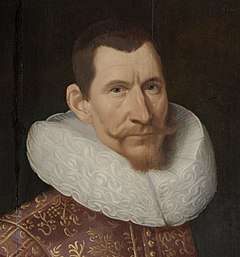
.jpg)
- Jacques Waben (ca.1590–ca.1634), painter
- Jan Albertsz Rotius (1624–1666), painter
- Jacob Rotius (1644–1681), painter
- Johan Messchaert (1857–1922), singer
- Aaf Bouber (1885–1974), actress
- Anton Quintana (1937–2017), writer
- Corine Rottschäfer (born 1938), model and Miss World 1959
- Martin Brozius (1941–2009), actor
- George Baker (born 1944), singer
- Joop van Wijk (born 1950), documentary film director
- Simone van der Vlugt (born 1966), writer
- Maria Barnas (born 1973), writer and poet
- Tim Knol (born 1989), singer-songwriter
Sport
- Johannes van Hoolwerff (1878–1962), Olympic sailor
- Frans Hoek (born 1956), football player
- Ruud Heus (born 1961), football player
- Stephan van den Berg (born 1962), Olympic gold medallist windsurfer
- Silvan Inia (born 1969), football player
- Frank de Boer (born 1970), football player
- Ronald de Boer (born 1970), football player
- Minouche Smit (born 1975), swimmer
- Marja Vis (born 1977), speed skater
- Marcelien de Koning (born 1978), Olympic sailor
- Vera Koedooder (born 1983), racing cyclist
- Coen de Koning (born 1983), Olympic sailor
- Tine Veenstra (born 1983), bobsledder
- Adrie Visser (born 1983), track cyclist
- Wil Besseling (born 1985), golfer
- Willemijn Karsten (born 1986), handball player
- Robert Krabbendam (born 1986), basketball player
- Pim Ligthart (born 1988), road cyclist
- Ruud Vormer (born 1988), football player
- Maikel van der Werff (born 1989), football player
- Roland Alberg (born 1990), football player
- Nadine Broersen (born 1990), track and field athlete
- Marco Bizot (born 1991), football player
- Lorenzo Ebecilio (born 1991), football player
- Nicole Koolhaas (born 1991), volleyball player
- Brandley Kuwas (born 1992), football player
- Sonny Stevens (born 1992), football player
- Paul Kok (born 1994), football player
- Bas Schouten (born 1994), racing driver
- Nadine Visser (born 1995), track athlete
- Inessa Kaagman (born 1996), football player
- Maaike Boogaard (born 1998), racing cyclist
- Dani de Wit (born 1998), football player
- Dagmar Boom (born 2000), volleyball player
- Kenzo Goudmijn (born 2001), football player
- Sontje Hansen (born 2002), football player
Residing
This is a non-exhaustive list of notable (former) residents of Hoorn:
- David Pietersz. de Vries (ca.1593–1655), explorer
- Andreas Cellarius (1596–1665), cartographer
- Jan Albertsz Rotius (1624–1666), painter
- Miep Gies (1909–2010), hid Anne Frank from the Nazis
- Edgar Vos (1931–2010), fashion designer
- Milly Scott (born 1933), first black Eurovision Song Contest entrant
- Ernesto Hoost (born 1965), kickboxer
- Sylvana Simons (born 1971), presenter and politician
Twin cities
The City of Hoorn has a twin city status with:
See also
References
- "Samenstelling" [Members] (in Dutch). Gemeente Hoorn. Archived from the original on 10 March 2014. Retrieved 10 March 2014.
- "Kerncijfers wijken en buurten" [Key figures for neighbourhoods]. CBS Statline (in Dutch). CBS. 2 July 2013. Retrieved 12 March 2014.
- "Postcodetool for 1625HV". Actueel Hoogtebestand Nederland (in Dutch). Het Waterschapshuis. Archived from the original on 21 September 2013. Retrieved 10 March 2014.
- "Bevolkingsontwikkeling; regio per maand" [Population growth; regions per month]. CBS Statline (in Dutch). CBS. 1 January 2019. Retrieved 1 January 2019.
- http://www.netherlands-tourism.com/hoorn/
- Neglected Churches Are Given New Use In the Netherlands, New York Times 10 March 1997
- "Malacca, a Dutch conquest forgotten". Malaysian Dutch Descendants Project. Archived from the original on 25 September 2015. Retrieved 9 July 2013.
- "Twin Cities plan will boost Malacca". New Straits Times. Retrieved 9 July 2013.
- "Bandar Kembar Melaka, Hoorne" (PDF) (in Malay). Pustaka Perdana Library. Archived from the original (PDF) on 25 September 2015. Retrieved 9 July 2013.
Literature
- Lourens, Piet; Lucassen, Jan (1997). Inwonertallen van Nederlandse steden ca. 1300–1800. Amsterdam: NEHA. ISBN 9057420082.CS1 maint: ref=harv (link)
External links
| Wikimedia Commons has media related to Hoorn, North Holland. |
| Wikisource has the text of the 1921 Collier's Encyclopedia article Hoorn. |
Places adjacent to Hoorn | |
|---|---|

| Authority control |
|---|