Hontheim
Hontheim is an Ortsgemeinde – a municipality belonging to a Verbandsgemeinde, a kind of collective municipality – in the Bernkastel-Wittlich district in Rhineland-Palatinate, Germany.
Hontheim | |
|---|---|
 Coat of arms | |
Location of Hontheim within Bernkastel-Wittlich district 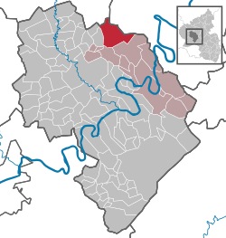 | |
 Hontheim  Hontheim | |
| Coordinates: 50°4′7.21″N 6°59′30.81″E | |
| Country | Germany |
| State | Rhineland-Palatinate |
| District | Bernkastel-Wittlich |
| Municipal assoc. | Traben-Trarbach |
| Subdivisions | 4 |
| Government | |
| • Mayor | Ilona Lauxen (WG Steffens) |
| Area | |
| • Total | 24.77 km2 (9.56 sq mi) |
| Elevation | 385 m (1,263 ft) |
| Population (2018-12-31)[1] | |
| • Total | 808 |
| • Density | 33/km2 (84/sq mi) |
| Time zone | CET/CEST (UTC+1/+2) |
| Postal codes | 54538 |
| Dialling codes | 02674 |
| Vehicle registration | WIL |
Geography
Location
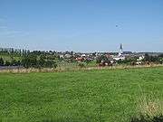
The municipality lies on a plateau in the southern Volcanic Eifel at the northern edge of the Kondelwald forest. The municipal area is 58.4% wooded. Hontheim belongs to the Verbandsgemeinde of Traben-Trarbach.
Constituent communities
Hontheim's Ortsteile, besides the main centre, are Wispelt, Krinkhof and Bonsbeuern.
History
Beginning in 1794, Hontheim lay under French rule. In 1814 it was assigned to the Kingdom of Prussia at the Congress of Vienna. Since 1947, it has been part of the then newly founded state of Rhineland-Palatinate.
Politics
Municipal council
The council is made up of 12 council members, who were elected by proportional representation at the municipal election held on 7 June 2009, and the honorary mayor as chairwoman.
The municipal election held on 7 June 2009 yielded the following results:[2]
| Steffens | Götten | Komes | Gellner | Total | |
| 2009 | 7 | 2 | 2 | 1 | 12 seats |
Economy and infrastructure
Through the municipality runs Bundesstraße 421. To the west runs the Autobahn A 1. In Ürzig is a railway station on the Koblenz-Trier railway line. The state spa town of Bad Bertrich, with Germany's only Glauber's salt (sodium sulphate decahydrate; Na2SO4•10H2O) hot spring, is only 3 km away.
References
- "Bevölkerungsstand 2018 - Gemeindeebene". Statistisches Landesamt Rheinland-Pfalz (in German). 2019.
- Kommunalwahl Rheinland-Pfalz 2009, Gemeinderat
- Hontheim’s arms
External links
- Hontheim (in German)
| Authority control |
|
|---|