Volcanic Eifel
The Volcanic Eifel or Vulkan Eifel (German: Vulkaneifel) is a region in the Eifel Mountains in Germany that is defined to a large extent by its volcanic geological history. Characteristic of this volcanic field are its typical explosion crater lakes or maars, and numerous other signs of volcanic activity such as volcanic tuffs, lava streams and volcanic craters like the Laacher See. The Volcanic Eifel is still volcanically active today. One sign of this activity is the escaping gases in the Laacher See.
Geographical location

The Volcanic Eifel stretches from the Rhine to the Wittlich Depression. It is bordered in the south and southwest by the South Eifel, in the west by Luxembourg and Belgian Ardennes and in the north by the North Eifel including the Hohes Venn. To the east the Rhine forms its geographical boundary, with no volcanicity immediately beyond it.
The Volcanic Eifel is divided into three natural regions:
- Volcanic West Eifel (Manderscheid, Daun, Gerolstein, Obere Kyll, Hillesheim (within the parish of Nohn),
- Volcanic High Eifel (Adenau, Kelberg, Ulmen and Nohn),
- Volcanic East Eifel (Brohltal, Vordereifel, Mendig, Pellenz)
The centre of the Volcanic Eifel is the region around Daun and Manderscheid and the areas within the Mayen-Koblenz district.
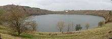
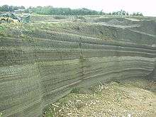
The landscape of the Volcanic Eifel is dominated by recent volcanism. Volcanic craters, thick pumice and basalt layers and maars create a diverse landscape that clearly witnesses to very recent events in geological terms.
The entire Volcanic Eifel covers an area of about 2000 km² and as of 2007 has a population of about 200,000.
Volcanoes
The following volcanoes belong to the Eifel, sorted by height in metres (m) above sea level (Normalhöhennull, NHN)[1]:
- Ernstberg (also: Erresberg; 699.8 m), county of Vulkaneifel – west
- Scharteberg (691.4 m), county of Vulkaneifel; with the Eifel Transmitter (SWR) – west
- Prümscheid (681 m), county of Vulkaneifel – not volcanic (eponymous quartzite ridge; other summits being the Scharteberg and Dietzenley)
- Hochkelberg (674.9 m), county of Vulkaneifel; with a transmission mast on its south summit – Tertiary
- Nerother Kopf (651.7 m), county of Vulkaneifel; with the castle ruins of the Freudenkoppe – west
- Dietzenley (617.6 m), county of Vulkaneifel; with a wooden observation tower – west
- Arensberg (ca. 590 m), county of Vulkaneifel – Tertiary
- Hochsimmer (587.9 m), county of Mayen-Koblenz – east
- Gänsehals (575.3 m), county of Mayen-Koblenz – east
- Engelner Kopf (575.1 m), county of Ahrweiler (near Kempenich-Engeln) – east
- Hochstein (563 m), county of Mayen-Koblenz – east
- Steineberger Ley (557.8 m), county of Vulkaneifel; with a Volcano Information Platform (observation tower) – Tertiary
- Rockeskyller Kopf (554.6 m), county of Vulkaneifel – west
- Hoher List (549.1 m), county of Vulkaneifel; with the Hoher List Observatory – west
- Wartgesberg (ca. 475 m), county of Vulkaneifel (near Strohn) – west
- Veitskopf (428.1 m), county of Ahrweiler; near Laacher See; with an observation tower, the Lydia Tower – east
- Ettringer Bellberg (427.5 m), county of Mayen-Koblenz (south of Ettringen) – east
- Karmelenberg (372.5 m), county of Mayen-Koblenz – east
- Mayener Bellberg (363.2 m), county of Mayen-Koblenz (north of Mayen) – east
- Korretsberg (295.0 m), county of Mayen-Koblenz (near Kruft) – east
→ See also: List of mountains and hills of the Eifel
Laacher See
Of particular note is the volcanic caldera known as Laacher See, the site of an eruption around 12,900 years ago that had an estimated VEI of 6.
Geopark and museums
- Vulkanland Eifel National Geopark
- Volcano Museum, Daun
- Volcano House, Strohn
- German Volcano Museum, Mendig
Future eruptions?
There is thought that future eruptions may occur in the Eifel, as:[2][3]
- Each year the Eifel rises by about a millimetre.
- Geophysicists found that crust under the Eifel is thinner than most continental crust, suggesting that under the Eifel is a hot zone where magma is rising.
- Persistent small earthquakes and underground heating.
- Map of flood lake that may happen if the Rhine is blocked by a voluminous eruption in the Eifel
References
- GeoViewer of the Federal Office of Geoscience and Resources (Bundesanstalt für Geowissenschaften und Rohstoffe)
- Is there still volcanic activity in the Eifel?
- Germany: a danger of volcanic eruptions?
Further reading
- Werner P. D’hein: Vulkanland Eifel. Natur- und Kulturführer, mit 26 Stationen der „Deutschen Vulkanstraße“. Gaasterland Verlag, Düsseldorf 2006, ISBN 3-935873-15-8, ISBN 978-3-935873-15-4
- Wilhelm Meyer: Geologie der Eifel. Schweizerbart’sche Verlagsbuchhandlung, Stuttgart 1986. ISBN 3-510-65127-8
- Hans-Ulrich Schmincke (2000). Vulkanismus. Darmstadt: Wissenschaftliche Buchgesellschaft. ISBN 978-3-534-17471-3.
External links
| Wikimedia Commons has media related to Eifel. |
- Homepage of Vulkaneifel district
- German Volcanological Society
- Smithsonian Institution's Global Volcanism Program: West Eifel Volcanic Field
| Authority control |
|
|---|