Hillhead (ward)
Hillhead (Ward 11) is one of the 23 wards of Glasgow City Council. On its creation in 2007 and in 2012 it returned four council members, using the single transferable vote system.[2] For the 2017 Glasgow City Council election, the boundaries were changed substantially, the ward slightly decreased in population and returned three members.
Hillhead
| |
|---|---|
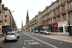 View looking west along Great Western Road which bisects the Hillhead ward | |
| Area | 2.92 km2 (1.13 sq mi) |
| Population | 25,411 (2015)[1] |
| • Density | 8,702.4/km2 (22,539/sq mi) |
| Council area | |
| Lieutenancy area |
|
| Country | Scotland |
| Sovereign state | United Kingdom |
| Post town | GLASGOW |
| Postcode district | G3, G4, G12, G20 |
| Dialling code | 0141 |
| Police | Scotland |
| Fire | Scottish |
| Ambulance | Scottish |
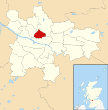
Boundaries
Situated to the west of Glasgow city centre, the core of the ward which has remained since its 2007 creation consists of Hillhead, Kelvinbridge, Gilmorehill (the University of Glasgow main campus), Woodlands and Woodside, with boundaries being the M8 motorway to the south-east and the Port Dundas branch of the Forth and Clyde Canal to the north-east.
Other aspects of the ward were substantially altered in 2017, with the Dowanhill and Hyndland neighbourhoods reassigned to a new Partick East/Kelvindale ward and Byres Road becoming the south-west boundndary; most of the North Kelvinside neighbourhood (streets to the east of Queen Margaret Drive, which became Hillhead's north-west boundary) was gained from the Canal ward, and the Park District (along with Kelvingrove Park itself) was gained from the Anderston/City ward, with the park's south entrances the new southern boundary of Hillhead.
Following these alterations, it was the smallest ward in physical size but the most densely populated, despite the park taking up a proportion of the territory.
Demographics
According to the 2011 census,[3] the ethnicity of the population was:
| Ethnicity | Proportion |
|---|---|
| White Scottish/British | 68.97% |
| White Irish | 3% |
| Other White | 8% |
| Mixed Ethnic Groups | 1.17% |
| Indian | 2.33% |
| Pakistani | 6.08% |
| Bangladeshi | 0.02% |
| Chinese | 4.89% |
| Other Asian | 1.61% |
| African | 1.81% |
| Caribbean or Black | 0.03% |
| Other Ethnic Group | 1.63% |
Councillors
| Election | Councillors | |||||||
|---|---|---|---|---|---|---|---|---|
| 2007 | Hanzala Malik (Labour) |
Kenneth Elder (Liberal Democrats) |
George A Roberts (SNP) |
Martha Wardrop (Green) | ||||
| 2011 by | Ken Andrew (SNP) | |||||||
| 2012 | Martin McElroy (Labour) |
Pauline McKeever (Labour) | ||||||
| 2017 | Hanzala Malik (Labour) |
3 seats | ||||||
Current representation
The three councillors representing the area since 4 May 2017 are:
- Martha Wardrop[4] (Scottish Greens)
- Ken Andrew[5] (Scottish National Party)
- Hanzala Malik[6] (Scottish Labour)
Election results
2007
2011 by-election
| |||||||||||||||||||||||||||||||||||||||||||||||||||||||||||||||||||||||||||||||||||||||||||||||||||||||||||||||||||||||||||||||||||||||||||||||||||||||||||||||||||||||||||||||||||||||||||||||||||||||||||||||||||||||||||||||||||||||||||||||||||||||||||||||||||||||||||
2012
| |||||||||||||||||||||||||||||||||||||||||||||||||||||||||||||||||||||||||||||||||||||||||||||||||||||||||||||||||||||||||||||||||||||||||||||||||||||||||||||||||||||||||||||||||||||||||||||||||||||||||||||||||||||||||||||||||||||||||||||||||||||||||||||||||||||||||||||||||
2017
| |||||||||||||||||||||||||||||||||||||||||||||||||||||||||||||||||||||||||||||||||||||||||||||||||||||||||
See also
References
- City Ward Factsheets 2017: Ward 11 - Hillhead, Glasgow City Council
- Teale, Andrew (27 December 2008). "Local Election Results 2007 (Glasgow)" (PDF). Local Elections Archive Project. Retrieved 4 May 2012.
- https://www.glasgow.gov.uk/CHttpHandler.ashx?id=9537&p=0
- Martha Wardrop
- Ken Andrew
- Hanzala Malik
- "Labour MSP under fire for double job". HeraldScotland. 29 September 2011. Retrieved 8 March 2020.
- http://www.glasgow.gov.uk/en/News/HillheadByElection.htm
- http://webarchive.nationalarchives.gov.uk/20121003152712/http://www.glasgow.gov.uk/en/YourCouncil/Elections_Voting/Election_Results/Hillhead_ByElection_2011/
- https://www.glasgow.gov.uk/index.aspx?articleid=21080
External links
- Listed Buildings in Hillhead Ward, Glasgow City at British Listed Buildings