Highway 77 (Israel)
Highway 77 is an east-west highway in northern Israel. It crosses the Lower Galilee in the region of the Beit Netofa Valley. The road leads from the Tel Qashish Interchange nearby Yokneam Illit to Tiberias. It is 48 km long. Its western section, from the Tel Qashish Interchange to the Golani Interchange is a freeway.
| |
|---|---|
| כביש 77 Kvish Shiv'im v'Sheva' | |
 | |
| Route information | |
| Length | 48 km (30 mi) |
| Major junctions | |
| West end | Tel Qashish Interchange |
| East end | Bank Leumi Junction |
| Location | |
| Major cities | Yokneam Illit, Tiberias |
| Highway system | |
| Roads in Israel Highways | |

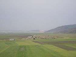
Highway 77 passes through the Beit Netofa Valley.
Junctions & Interchanges on the highway
| km | Name | Type | Meaning | Location | Intersecting routes |
|---|---|---|---|---|---|
| 0 | מחלף תל קשיש (Tel Qashish Interchange) |
named after adjacent archeological site |
Tel Qashish, Yokneam |
||
| 9 | Yishai Junction | Jesse | Ramat Yishai | ||
| Yishai Interchange | Planned[1] | ||||
| 12 | Zarzir Interchange | starling | Zarzir | Route 7626 | |
| 15.5 | HaMovil Interchange | aqueduct | HaSolelim | ||
| 27 | Beit Rimon Junction | house of pomegranate | Kafr Kanna | ||
| Beit Rimon Interchange | Planned | ||||
| 33 | Golani Interchange | named after Golani Brigade |
Ilaniya | ||
| 42 | Poriya Junction | fruitful | Tiberias, to Poria |
||
| 45 | Kfar Hittim Junction | village of wheat | Tiberias | Route 7717 | |
| 48 | Bank Leumi Junction | named for longstanding location of bank[2] |
Tiberias | ||
Places of interest on Highway 77
- HaSolelim forest nature reserve
- Monument to the Bedouin soldier
- Eshkol Reservoir
- The church and the grave of Rabban Shimon ben Gamliel in Kafr Kanna
- Memorial to the Golani Brigade at the Golani Interchange
- Lavi forest
- The Sea of Galilee
See also
- List of highways in Israel
- Lower Galilee
- Beit Netofa Valley
- "Highway 77 - Between Yishai Junction and Tel Qashish". National Roads Company of Israel. Archived from the original on 2013-10-21. Retrieved 2013-08-28.(in Hebrew)
- Bank Leumi Junction, Tiberias (Map). Google Maps. Retrieved 2013-08-28.
| Roads |
| ||||
|---|---|---|---|---|---|
| Bus operators | |||||
| Rail transport |
| ||||
| Sea ports | |||||
| Aviation |
| ||||
| Cable cars | |||||
| By city | |||||
| Smart cards | |||||
This article is issued from Wikipedia. The text is licensed under Creative Commons - Attribution - Sharealike. Additional terms may apply for the media files.