Guallatiri
Guallatiri is a 6,071-metre (19,918 ft) high volcano in Chile. It is located southwest of the Nevados de Quimsachata volcanic group and is sometimes considered to be part of that group. It is a stratovolcano with numerous fumaroles around the summit. The summit may be composed of either a lava dome or a pyroclastic cone, while the lower flanks of the volcano are covered by lava flows and lava domes. The volcano's eruptions have produced mostly dacite along with andesite and rhyolite.
| Guallatiri | |
|---|---|
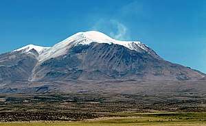 Fumarole activity in the crater of Guallatiri | |
| Highest point | |
| Elevation | 6,071 m (19,918 ft) [1] |
| Isolation | 25 km (16 mi) |
| Coordinates | 18°25′00″S 69°05′30″W [2] |
| Naming | |
| Native name | Wallatiri |
| Geography | |
 Guallatiri Location of Guallatiri in Chile | |
| Location | Putre, Parinacota Province, Arica y Parinacota, Chile[3] |
| Geology | |
| Age of rock | Pleistocene-Holocene |
| Mountain type | Volcano |
| Volcanic field | Nevados de Quimsachata |
| Last eruption | 1960 |
Guallatiri has been active in historical times with a number of eruptions, the latest in 1960. Fumarolic and seismic activity is ongoing and has resulted in the deposition of sulfur and other minerals on the volcano. The volcano is covered by an ice cap above 5,500 metres (18,000 ft) elevation. Guallatiri, along with several other volcanoes, is part of Lauca National Park.
Geography
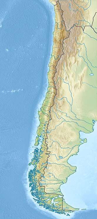
Guallatiri is located in the Putre commune of Parinacota province in the Arica y Parinacota Region of Chile. The towns of Putre, Socoroma and Zapahuira are closest to the volcano;[3] other nearby communities include Ancuta, Chachacomani, Chiriguaya, Jancoaque and Uncaliri.[4][5] The name of the volcano comes from Aymara Wallatiri, meaning "place of the wallata",[6][7] with wallata meaning Andean goose. The volcano is also known as Huallatiri, Huallatire, Guallatire and Punata.[1]
The volcano is located in the Lauca National Park, along with the two higher Pomerape and Parinacota volcanoes;[8] the volcanoes Parinacota, Quisiquisini, Guallatiri and Poquentica form the eastern limit of the Lauca basin.[9] Sometimes Guallatiri is considered to be part of the Nevados de Quimsachata volcanic chain, a 50 kilometres (31 mi) long chain of volcanoes.[10][4]
Other volcanoes with historical phreatic-phreatomagmatic activity in northern Chile include Irruputuncu, Isluga, Lascar and San Pedro. Further, fumarolic activity has been reported at Alitar, Lastarria, Olca, Ollague, Putana and Tacora.[11]
Geology
Guallatiri is a 6,071 metres (19,918 ft) high[4] complex volcano[1] formed mainly by lava flows[12] but also featuring dacitic[1] or andesitic lava domes, such as Domo Tinto on the southern flank.[13] The volcano is 19.3 kilometres (12.0 mi) wide[4] and 1,700-metre-high (5,600 ft) above the basement rocks. The total volume of the volcano cannot be known with certainty, as it varies, but it amounts to between 40-86 cubic kilometers. The volcano's foot covers a surface of about 292 square kilometres (113 sq mi).[4] The summit is formed by a pyroclastic cone;[1] alternative interpretations see it as a lava dome or a hydrothermally altered, scree-covered lava plug.[14] The vent lies south of the summit[15] and the summit crater is breached westwards and northwards.[16]
Lava flows radiate from the summit and lava domes dot its flanks. Some lava flows are up to 7 kilometres (4.3 mi) long and 100 metres (330 ft) high[13] and thick lava flows are particularly noticeable on the western and northern slope of the volcano.[15] "Breadcrust" lava bombs are found on the northern flanks, probably carried there by glaciers.[14] Other eruption products include ash flows and tephra layers. The former are particularly developed on the south-southwest flank and the tephras particularly on the southern-eastern flanks.[17]
Guallatiri is underpinned by the rocks of the Lauca Formation,[18] which has an age of 10–0.5 million years.[19] An older basement domain known as the Lupica Formation is exposed north, west and south of the volcano and contains sediments and volcanic rocks. It is of Oligocene-Miocene age.[13] Like other volcanoes in the area, it formed on top of the Chilean Altiplano.[8]
Guallatiri may have formed during the Pliocene, with a second stage of volcanic activity recommencing during the Pleistocene;[20] the volcano started forming about 710,000 years ago.[4] Two stages of volcanic activity in the Pleistocene-Holocene have been identified,[17] although a three-stage chronology of volcanic activity has been proposed as well; this proposal envisages two earlier lavic stages and a third stage characterized by the emission of pyroclastics and lava domes.[21] Volcanic activity in the Quimsachata volcanic chain migrated south from the now deeply eroded Acotango and Humarata volcano to the more recent Capurata and Guallatiri volcanoes. There is evidence indicating that lava flows forming Stage I of volcanic activity were erupted during the middle Pleistocene and the lava domes forming Stage II were erupted in the Pleistocene-Holocene.[13] The lava bombs on the northern flank suggest that eruptions which produced small amounts of rocks occurred in recent times.[14]
Glaciation and hydrology
Guallatiri has glaciers, including one on the summit[1] and an ice cap above 5,500 metres (18,000 ft) elevation.[4] It is the most southern volcano in the Central Andes with an ice cap[10] as south of Guallatiri tropical summer precipitation is insufficient to support glaciation; only south of 27° does winter precipitation become sufficient to support glaciers again.[22] Fumaroles have melted holes in the glaciers.[23] Thin moraines are preserved on the flanks at altitudes of 4,260 metres (13,980 ft).[24][20]
These glaciers drain towards the Chungara river.[9] A number of streams and dry valleys originate on Guallatiri. Parts of the western and southern flank drain into the Rio Lauca.[25]
Petrology
Guallatiri has erupted andesite, dacite and rhyolite, with dacite dominating.[1] Pyroxene andesites are found up to 4,800 metres (15,700 ft) of altitude.[14] Analysis of lava at Domo Tinto lava dome has indicated that phenocrysts include amphibole, biotite, pyroxene and some apatite. Mafic inclusions have also been found in Domo Tinto rocks. The Domo Tinto eruption may have been triggered by the injection of basaltic andesite into two magma chambers containing crystalline andesite.[13] Native deposits of sulfur are also found[20] and sulfur is the most common mineral in fumarolic deposits; but arsenic, boron, calcium and silicon are also found. Such fumarolic deposits at Guallatiri and the other Andean volcano Lastarria aside from pure sulfur also consist of anhydrite, auripigment, baryte, burkeite, cristobalite, galena, gypsum, magnetite, pyrite, quartz and sassolite.[21]
Domo Tinto rocks have been analyzed for isotope and chemical composition studies. They are potassium-rich calc-alkaline rocks as is typical for Andean volcanism in this area. On the basis of petrology, magma temperatures of the Tinto rocks have been estimated at 790 °C (1,450 °F) for the andesitic component and 890–930 °C (1,630–1,710 °F) for the basaltic andesite component.[13] SiO2 contents range from 58 to 75%, with dacites having a content of 63–70%.[1]
Eruptive activity
Solfataric activity is ongoing. In 1985 and 1987 yellow (sulfur-bearing) steam clouds were reported, reaching heights of 500 metres (1,600 ft) above the summit.[1] The fumaroles cluster in two places,[21] in the crater[2] and on the southern flank where they reach over 300 metres (980 ft) down. The fumaroles are reported to make "jet"-like noises[15] and temperatures range from 83.2–265 °C (181.8–509.0 °F),[5] ASTER imaging has indicated temperature anomalies of up to 8 kelvins.[26] Water vapour and carbon dioxide making up the bulk of the gases, other components are hydrogen chloride, hydrogen fluoride, hydrogen sulfide, methane and sulfur dioxide.[5] Mud pots have also been observed.[27]
Likewise, the volcano features ongoing seismic activity, including about two earthquakes per day and three seismic swarms in 2011–2012. Another earthquake swarm was associated with the 2001 Peru earthquake.[26][28] No deformation of the edifice has been observed, however.[29]
The lava dome Domo Tinto was K-Ar dated at 5,000 ± 3000 BP. Its eruption was probably a relatively tranquil effusive eruption.[13] Present day volcanic activity is generally poorly documented, with minor phreatic eruptions recorded.[21] Ash eruptions are reported in the first half of the 19th century. In 1913 and 1959, glow was observed in the summit crater, and a phreatic eruption was reported in 1960.[1] Activity is also reported for 1779, 1802, 1826–1831, 1850, 1859, 1864, 1864, 1870, 1902, 1904, 1908, 1912 and 1959.[25] Guallatiri is one of northern Chile's most active volcanoes.[17] In 2015 volcano alert levels on Guallatiri was temporarily raised due to deformation of the edifice and changes in the seismic activity.[15]
Threats and preparedness
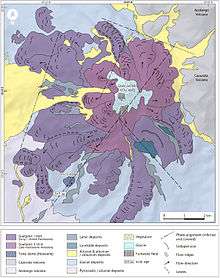
The Chilean National Geology and Mining Service keeps a record of regular reports of the activity status of Guallatiri,[3] which is considered to be Chile's 27th most dangerous volcano.[4] A hazard map exists of Guallatiri with three areas of different risk. The red zone occupies the areas interested by late activity of the volcano and river valleys, in total most of the upper parts of the volcano. The orange and yellow zones are areas threatened in the case of medium-large and large scale eruptive activity, respectively.[25]
Ash falls,[21] flank eruptions, lahars and pyroclastic flows are hazards associated with Guallatiri. The town of Guallatiri on its southern flank is especially threatened[1] as are the southern and eastern flanks in general.[4] Explosive activity with eruption columns of 20 kilometres (12 mi) height may result in ashfall in Arica and Putre depending on the season.[25] There are villages with hundreds of people,[5] including small villages in western Bolivia that may be impacted by Guallatiri tephra.[17]
Religious and archeological importance
Unlike on several other Andean summits, no Inka archeological sites are visible on Guallatiri, perhaps discouraged by the persistent volcanic activity.[30]
It is said that townsfolk living in the town of Guallatire worshipped the mountain from Capurata, a nearby mountain. Even today, churches in Ancuta and Guallatire point towards the volcano.[30]
See also
- List of volcanoes in Bolivia
- List of volcanoes in Chile
- Kuntur Ikiña
References
- Moreno, Hugo (10 January 2014). "Ficha ejecutiva: Volcán Guallatiri" (PDF). sernageomin.cl (in Spanish). SERNAGEOMIN. Archived from the original (PDF) on 30 September 2015. Retrieved 25 April 2016.
- Gliss, Jonas; Stebel, Kerstin; Thomas, Helen (2015). "SO2-flux measurements and BrO/SO2 ratios at Guallatiri volcano, Altiplano, northern Chile". Egu General Assembly Conference Abstracts. 17: 13466. Bibcode:2015EGUGA..1713466G.
- "Guallatiri". sernageomin.cl. SERNAGEOMIN. Archived from the original on 24 May 2016. Retrieved 25 April 2016.
- "Complejo Volcánico Guallatiri". SERNAGEOMIN (in Spanish). Retrieved 3 February 2019.
- Inostroza, Manuel; Aguilera, Felipe; Tassi, Franco; Capecchiacci, Francesco (September 2018). "Preliminary assessment of the origin and evolution of fluids discharged from Guallatiri volcano: Sampling plan, results and discussions" (PDF). ResearchGate. Naples, Italy. doi:10.13140/rg.2.2.32990.89925. Retrieved 2019-02-03.
- Bobylyova, E. S.; Сергеевна, Бобылева Елена (15 December 2016). "Structural-and-Semantic Analysis of Oronyms of Chile, Структурно-семантический анализ оронимов Чили". RUDN Journal of Language Studies, Semiotics and Semantics, Вестник Российского университета дружбы народов. Серия: Теория языка. Семиотика. Семантика (in Russian). 0 (2): 126. ISSN 2411-1236.
- Ministerio de Obras Pùblicas, Guía de diseño arquitectónico aymara para edificios y espacios públicos, Chile 2016
- Rundel, P.W.; Gibson, A.C.; Midgley, G.S.; Wand, S.J.E.; Palma, B.; Kleier, C.; Lambrinos, J. (2003). "Ecological and ecophysiological patterns in a pre-altiplano shrubland of the Andean Cordillera in northern Chile". Plant Ecology. 169 (2): 179–193. doi:10.1023/A:1026075721045.
- Sáez, A.; Valero-Garcés, B. L.; Moreno, A.; Bao, R.; Pueyo, J. J.; González-Sampériz, P.; Giralt, S.; Tabernier, C.; Herrera, C.; Gibert, R. O. (October 2007). "Lacustrine sedimentation in active volcanic settings: the Late Quaternary depositional evolution of Lake Chungará (northern Chile)". Sedimentology. 54 (5): 1191–1222. Bibcode:2007Sedim..54.1191S. doi:10.1111/j.1365-3091.2007.00878.x. hdl:2445/102006.
- Rundel, Philip W.; Palma, Beatriz (August 2000). "Preserving the Unique Puna Ecosystems of the Andean Altiplano". Mountain Research and Development. 20 (3): 262–271. doi:10.1659/0276-4741(2000)020[0262:PTUPEO]2.0.CO;2.
- Tassi, F.; Aguilera, F.; Darrah, T.; Vaselli, O.; Capaccioni, B.; Poreda, R.J.; Delgado Huertas, A. (April 2010). "Fluid geochemistry of hydrothermal systems in the Arica-Parinacota, Tarapacá and Antofagasta regions (northern Chile)". Journal of Volcanology and Geothermal Research. 192 (1–2): 1–15. Bibcode:2010JVGR..192....1T. doi:10.1016/j.jvolgeores.2010.02.006.
- Tilling, Roberto Scarpa, Robert I. (1996). "Satellite Monitoring of Volcanoes". Monitoring and Mitigation of Volcano Hazards. Berlin, Heidelberg: Springer Berlin Heidelberg. p. 266. doi:10.1007/978-3-642-80087-0_8. ISBN 978-3-642-80087-0.
- Watts, Robert B.; Clavero Ribes, Jorge; Sparks, R. Stephen J. (30 September 2014). "Origen y emplazamiento del Domo Tinto, volcán Guallatiri, Norte de Chile". Andean Geology. 41 (3). doi:10.5027/andgeoV41n3-a04. ISSN 0718-7106. Retrieved 26 April 2016.
- Wigger, edited by Klaus-Joachim Reutter, Ekkehard Scheuber, Peter J. (1994). "Large- and Fine-Scale Geochemical Variations Along the Andean Arc of Northern Chile (17.5°– 22°S)". Tectonics of the Southern Central Andes Structure and Evolution of an Active Continental Margin. Berlin, Heidelberg: Springer Berlin Heidelberg. pp. 81–82. doi:10.1007/978-3-642-77353-2_5. ISBN 978-3-642-77353-2.CS1 maint: extra text: authors list (link)
- "Guallatiri". Global Volcanism Program. Smithsonian Institution.
- Banks, Norman G. (10 January 1989). "Second annual report of the volcano early warning and disaster assistance program" (PDF). pdf.usaid.gov. United States Department of Interior U.S. Geological Survey. p. 38. Retrieved 26 April 2016.
- Teresa Moreno (Ph. D.); Wes Gibbons (2007). The Geology of Chile. Geological Society of London. p. 151. ISBN 978-1-86239-220-5.
- Charrier, Reynaldo; Chávez, Alvaro N.; Elgueta, Sara; Hérail, Gérard; Flynn, John J.; Croft, Darin A.; Wyss, André R.; Riquelme, Rodrigo; García, Marcelo (May 2005). "Rapid tectonic and paleogeographic evolution associated with the development of the Chucal anticline and the Chucal-Lauca Basin in the Altiplano of Arica, northern Chile". Journal of South American Earth Sciences. 19 (1): 35–54. Bibcode:2005JSAES..19...35C. doi:10.1016/j.jsames.2004.06.008.
- Charrier, Reynaldo; Hérail, Gérard; Pinto, Luisa; García, Marcelo; Riquelme, Rodrigo; Farías, Marcelo; Muñoz, Nelson (10 July 2012). "Cenozoic tectonic evolution in the Central Andes in northern Chile and west central Bolivia: implications for paleogeographic, magmatic and mountain building evolution". International Journal of Earth Sciences. 102 (1): 235–264. Bibcode:2013IJEaS.102..235C. doi:10.1007/s00531-012-0801-4.
- Groepper, H.; Calvo, M.; Crespo, H.; Bisso, C. R.; Cuadra, W. A; Dunkerley, P. M.; Aguirre, E. (1 October 1991). "The epithermal gold-silver deposit of Choquelimpie, northern Chile". Economic Geology. 86 (6): 1206–1221. doi:10.2113/gsecongeo.86.6.1206.
- "12° Encuentro Internacional Ciencias de la Tierra: Libro de Resúmenes" (PDF). Universidad Nacional de Cuyo (in Spanish). November 2017. Retrieved 3 February 2019.
- Ammann, Caspar; Jenny, Bettina; Kammer, Klaus; Messerli, Bruno (August 2001). "Late Quaternary Glacier response to humidity changes in the arid Andes of Chile (18–29°S)". Palaeogeography, Palaeoclimatology, Palaeoecology. 172 (3–4): 313–326. Bibcode:2001PPP...172..313A. doi:10.1016/S0031-0182(01)00306-6.
- Rivera, Andrés; Bown, Francisca; Casassa, Gino; Acuña, Cásar; Clavero, Jorge (December 2005). "Glacier shrinkage and negative mass balance in the Chilean Lake District (40°S) / Rétrécissement glaciaire et bilan massique négatif dans la Région des Lacs du Chili (40°S)". Hydrological Sciences Journal. 50 (6). doi:10.1623/hysj.2005.50.6.963.
- Ochsenius, Claudio (1986). "La Glaciación Puna durante el Wisconsin, Desglaciación y Máximo Lacustre en la Transición Wisconsin-Holoceno y Refugios de Megafauna Postglaciales en la Puna y Desierto de Atacama" (PDF). Revista de Geografía Norte Grande (in Spanish). 29–58 (13). Archived from the original (PDF) on 2016-03-04. Retrieved 13 September 2015.
- "Peligros volcánicos del volcán Guallatiri" (PDF). SERNAGEOMIN Home (in Spanish). SERNAGEOMIN. Archived from the original (PDF) on 22 October 2016. Retrieved 26 April 2016.
- Pritchard, M.E.; Henderson, S.T.; Jay, J.A.; Soler, V.; Krzesni, D.A.; Button, N.E.; Welch, M.D.; Semple, A.G.; Glass, B.; Sunagua, M.; Minaya, E.; Amigo, A.; Clavero, J. (June 2014). "Reconnaissance earthquake studies at nine volcanic areas of the central Andes with coincident satellite thermal and InSAR observations". Journal of Volcanology and Geothermal Research. 280: 90–103. Bibcode:2014JVGR..280...90P. doi:10.1016/j.jvolgeores.2014.05.004.
- "Summary of recent volcanic activity". Bulletin of Volcanology. 53 (7): 575–576. September 1991. Bibcode:1991BVol...53..575.. doi:10.1007/BF00298158.
- Henderson, Scott T.; Pritchard, Matthew E.; Jay, Jennifer A.; Welch, Mark; Mares, Peter J.; Mnich, Marissa E. (January 2012). "Searching for Activity in the Andean Central Volcan ic Zone: Thermal Anomalies, Seismicity, and Deformatio n Over a Timespan of 1–20 years" (PDF). biblioserver.sernageomin.cl. SERNAGEOMIN. Retrieved 25 April 2016.
- Pritchard, Matthew E.; Simons, Mark (11 July 2002). "A satellite geodetic survey of large-scale deformation of volcanic centres in the central Andes". Nature. 418 (6894): 167–171. Bibcode:2002Natur.418..167P. doi:10.1038/nature00872. PMID 12110886.
- Reinhard, Johan (January 2002). "A high altitude archaeological survey in Northern Chile". Chungará (Arica). 34 (1). doi:10.4067/S0717-73562002000100005.