Gojal
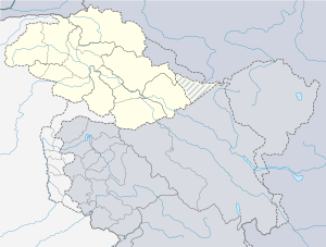
Gojal (Urdu: وادی گوجال) , also Called "Upper Hunza", is situated in the far north of Pakistan. It borders China at the Khunjerab Pass and Shimshal valley and Afghanistan at the Chipurson valley. In 2019, Gojal Valley became the second Sub-Division within the Hunza District. It is geographically the largest Sub-Division of the Gilgit-Baltistan region of Pakistan.
| Gojal | |
|---|---|
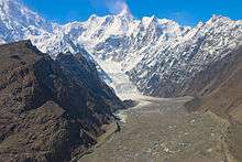
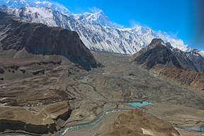 The Batura glacier, one of the longest outside the Polar region, is in Gojal. | |
 Gojal  Gojal | |
| Naming | |
| Native name | وادی گوجال (Urdu) |
| Geography | |
| Country | |
| State/Province | |
| District | Hunza District |
| Coordinates | 36.39°N 74.87°E |
Gojal, also known as Upper Hunza, is composed of a number of large and small valleys sharing borders with Central Hunza in the South, China in the north-east and Afghanistan in the north-west. Aeenabad is the first village of Gojal, Upper Hunza. Except for the Shimshal, Misgar and Chipursan valleys, all the villages of Gojal, Upper Hunza can be seen from the Karakorum Highway (KKH), which crosses Gojal, entering China at the Khunjerab Pass. The Gojal region has 20,000 Ismaili residents.[1]
History
The valleys and villages of Gojal were settled over time by people from surrounding regions. Kirghiz nomads initially used the areas in Upper Gojal as winter pastures. Wakhis migrated from Wakhan to this region, the Yishkuk (Chipursun) valley, the Avgarch area of Gircha and Sost villages were settled in the upper Gojal while in the lower Gojal Hussaini is considered an ancient settlement. When Hunza was under the Central Government of Gilgit the Ishkook settlement was wealthy and paid cattle and other dairy products to the Raja of Gilgit. As Hunza emerged as an independent state during the early 15th century so it can be inferred that different valleys in upper Gojal were inhabited by the Wakhi speaking migrants prior to the emergence of the Hunza state. Later, the oral history holds, a catastrophic flood destroyed the Ishkook settlement during the 18th century.
Since 2010, parts of the valley have been inundated by the 27 km long Attabad Lake
Shishkat
Shishkat is also known as Nazimabad Shishkat is the first village of Gojal valley which borders Gojal with Hunza. The total population of the village is 2,160 individuals living within 220 households. This is dominantly a Burushaski speaking village. However, a sizable population of Wakhi and Domaaki speakers also live in the village. The village was settled down in 1903 during the reign of Mir Nazim Khan. Before this the barren lands were used as grazing land of the Gulmit village. Some Wakhi households from Gulmit also permanently settled down in Shishkat while the Burushaski and Domaaki people migrated from Central Hunza. The village also has historical significance because this was the battle ground between the Wakhi population above Gulmit and the state of Nagar and Hunza.
Gulmit - The Sub-Division Headquarters
Gulmit is the administrative headquarters of the Gojal Sub-Division. Gulmit is a centuries-old historic town, with mountains, peaks and glaciers. It is a tourist spot and has many hotels, shops and a museum. It is located 2,408 meters (7,900 feet) above the sea level. Gulmit consists of small hamlets called Kamaris, Odver, Dalgiram, Laksh, Kalha, Shawaran, Khor Lakhsh, Chamangul and Goze. Gulmit is home to around 4,000 people, all of them Wakhi-speakers and followers of the Ismaili school of thought of Shia Islam.
Before 1974, when Hunza was a state, Gulmit used to be the Summer Capital of the state. After the abolition of the state it became the Tehsil's seat of government. The oldest intact house in Gulmit is more than six centuries old.
There are six Jama'at Khana or religious community centres in Gulmit. One notices their presence in every ward of the village. The old Summer Palace of Mir of Hunza stands at the northern edge of Gulmit's historic Polo Ground. Old mosques, now used as libraries, also adorn the beautiful physique of Gulmit valley.
Among new buildings constructed by the government in Gulmit are Tehsil Headquarters, Federal Government's Boys High School, Civil Hospital, Diamond Jubilee Girls Middle School and Government Girls Higher Secondary School.
Al- Amyn Model School, a community-based organization, has a beautiful building standing next to the Health Center of Aga Khan Health Services.
Settlement of Passu
Passu is located with 125 km from Gilgit on the KKH near the border of China and is surrounded by the mountains of the Karakoram range. Its neighbourhood also includes two large glaciers: Batura and Passu Glacier. It is one of the most dangerous places to live in due to the continuous threat of floods and has been flooded four times in the past. Passu is also one of the most ancient villages in the area. According to archeologists, the first human settlement in the area dates back to 3000 BC or 5000 BC. There are many ancient rock carvings of ibex and zebra on several rocks, showing that ibexes have been around in the valley for many millennia, but the area no longer houses zebras. the only other wildlife here are snow leopards and yaks. In the second settlement era, Chinese Buddhists lived here. The buddhists of Gandahara, Swat, Gilgit, and Passu travelled from via this valley to go to China. Records of this settlement and subsequent migration are found in Karga Gilgit and Khurramabad Passu. The third settlement in the history of this valley is the Islamic era. Islam came to this area in the ninth century when Arab soldiers and traders ventured to these parts of the world. Quranic verses were etched in the mountains around the valley during this era. The fourth era was also Islamic, which was settled here in the 18th century. This time, the area boasted a vibrant populace of 315 families. However, this village was destroyed by a natural disaster with a landslide and the nearby river was blocked. Only a few families remained safe by the landslide. This village was destroyed once again in 1964 when the population was forced into migration by the flooding of the Shimshal river and erosion around the river bank. This time around too, the village had some 300 houses. The majority of Passu's native population recognises its ancestor as a man named Quli, who had come from Wakhan in the 15th century. In his memory, the people of Passu are also known as Quli-kuts or kutor. The quli-kuts tribe has also inhabited Karimabad, Murtazabad and many other villages of central Hunza. The quli-kuts in central Hunza later adopted the Burushu way of life and now speak the Burushaski language. Most of the families migrated to chapurson and Khyber. Among the current inhabitants of Passu are seven families: the Alvi, Mughani, Dinali, Sakhi, Quba, and Hadab. The latest figures put the population of Passu around 1,000.
Ghulkin Gojal
Ghulkin Village is located in Gojal. It is reached by following the Karakoram Highway (KKH)
140 km north of Gilgit. This trip takes 3–4 hours by van. From a turn-off just beyond Gulmit, a winding jeep track leads upwards for 3 km, until the ground flattens out and the first houses of the village come into view.
Ghulkin occupies the site of an old glacier fed lake, which has been silted up by continuous sedimentation. Many of the 140 traditional dwellings that constitute Ghulkin village are arranged in a circular form, facing the one-time shores of the lake, creating a wonderfully communal atmosphere. The central area now supports several dwellings and fields, including a strip of land often used as a cricket pitch.
There is no accurate historical record of the origin of the village, though it is estimated to be around 700 years old. According to local folklore, there were settlements here while the lake was still in existence, this area being used as pastureland in summer. The name is derived from two words of the local Wakhi dialect, 'Ghulk', meaning 'well' and 'kin', meaning 'whose'. Being an area of low rainfall, the most vital requirement is water for irrigation, livestock, drinking and domestic use. Khawaja Ahmed, and Ismaili Muslims who came here with the Mir of Hunza, asked him for land. After the Mir agreed, Khawaja Ahmed mobilised the people of the area to construct a water-channel to irrigate the land. This made cultivation possible and the Ismaili settlement flourished. Now small scale health and educational institutions, electricity and water-sully facilities are available in the village. Through the involvement of capacity-building NGOs, there is also a handicraft production centre and opportunities for other vocational training. The Jama'at Khana, the central religious institution for all Ismaili Muslims, holds a strong position in the community. Apart from its religious functions, it provides a central location for community meetings, festivals, celebrations, resolution of disputes and other community activities. In Upper Hunza, winters are long and can become bitterly cold. Snowfall brings with it the Siberian ibex, descending in search of grass under the snow cover. Summers are hot in the north, though more pleasant than the harsh temperatures in summer are around 30 °C. In winter the temperature remains below freezing point, further dropping at night.
Hussaini

Hussaini village is one of the new settlements of the Wakhi people in the Gojal valley. Hussaini is surrounded by the Ghulkin Glacier and the Khunjarav River and the Karakorum Highway passes through the middle of the village.
People: The residents of Hussaini are ethnically Wakhi and speak Xikwor or Wakhi language. Most of the residents are from the passu village of Sahki family and few are from Broghil chitral known as Musofeer,s -
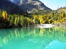
Religion: The people of Hussaini like all other people in Gojal are followers of the Ismaili school of thought in Islam. Tourist Attractions: Hussaini Suspension Bridge, Borith Lake Ghulkin, Zarabod and Sultan e Shahtalib (decades old shrine of a saint) are famous tourist attractions of the Hussaini village of Gojal valley.
Avgarch
One of the oldest strongholds of the Wakhis against the Kirghiz and other invaders is located in a valley starting at Murkhun. There are two forts, namely Pasth Qlha and Wuch Qlha, an Ismaili mosque and Watch towers in Avgarch. These historic sites are still in use. Baba Sufi is considered one of the first to settle in Gojal along with his wife. He settled by the spring of Gircha but abandoned it from the fear of looters, his clan later kept using Gircha as a fertile land and took the crops back to Avgarch. The settler of Shimshal, Mamu Singh also went through the Avgarch and Qorun Pass. Legends say his wife was also from Avegarch. Later Mir Silum Khan of Hunza convinced people to settle Gircha and use Avgarch for one season. During the invasion of the British the people from all lower Gojal and Hunza, took shelter in Avgarch. Later British came to Avgarch and asked people to go back to their home with assured safety.
Avgarch is one a tourist attraction with a 1.5 hour hike from the KKH, She offers beautiful pastures and hamlets, glaciers and peaks, yosinband, Old graves of Kirghiz, the oldest Juniper tree of Hunza the Baltar Yarz, Boibar valley, Priyar and the famous Qorun pass.
Gircha
A spring village, by the KKH is one of the first settled lands in Gojal. Settled by Wakhi legend Bobo e Sufi, his generation used this land to just to grow crops for long, then a fort was built in Gircha which became the centre of political activities for Mirs, sarai for travelers/explorers and Ismaili Missionaries. Gircha has a geographical significance as there are proofs that provide unique litho- and biofacies which has led to the term[2] Gircha has been flooded multiple times, woods etc can be seen in the sediments made visible by recent erosion.
A flood from Dilboy stopped the Khunjerav River which eroded the old village and fort. People relocated the fort but the erosion continued and people had settle new villages nearby, namely; Sost, Nazimabad, Murkun, Jamalabad and Ghalapan.
Residents include the Bobo Sufi clan, further divided into Rumi kutor, Posh kutor and Arbob kutor, some Wakhi later inhabited the place and are called khik kutor, in era of Mir Nazim Burushaski families were also settled.
Gircha remains a centre of interest for visitors around the world, there are various springs which run the villages activities, fossils, corals, sea shells, the oldest mosque and school of the region, historic houses, and traditions. The village is self sufficient due to its own electric power house, vocational center, and the first and only veterinary and trout fish farm are also found in here.
Sost
Sost is the last border town of Pakistan which leads the KKH to China through Khunjerab. Sost is the center of activities in upper Gojal with office of Assistant Magistrate, an established bazaar, a dry port, customs and other official setups. Sost is also an old village, with a diverse population. An old house related to Bobo e Sufi is visitable, a Shrine of Saint Baba Sheikh Farid, brother of Shah Shams and Shah Talib is a place of interest for visitor.
In 1985 a long tunnel was dug by locals with the supervision of AKRSP to irrigate the pasture of Sost, which was named Hussainabad. Sost comprises four settlements known as Nazimabad, Center Sost, Afiyatabad (Known as Sost Bazar) and Hussainabad.
Nazimabad
Nazimabad is a village in Sost settled in 1910. The initial settlement started with the orders of Mir of Hunza, Mir Nazim Khan and hence the name Nazimabad was emerged. This village is a diverse population of nearly 800 inhabitants including Burushaski and Wakhi speakers.
Chapursan (Wakhi: چپورسن; also spelt Chipurson, Chipurson, Chaporsan, Chupurson) is a valley containing some eight scattered villages within the Hunza District of Gilgit-Baltistan, Pakistan. It is the most Northern part of Pakistan, bordering Afghanistan and China. The majority of the people in the valley speak the Wakhi Language, but the villagers of Raminj speak the Burushaski language and belong to the Ismaili sect of Islam.[citation needed] Chipurson Valley hosts over 500 households with a population of 3,000.
Geography
Geographically Gojal, Upper Hunza is located between 70 latitude and 61 and is spread over an area of 10,873 km² of land, at an elevation ranging from 2,340m to 4,877m above sea level.
Gojal is a mountainous region forming the western part of the Karakoram and Eastern Pamir mountain range. This area also hosts the 56 km long Batura glacier the third longest of Pakistan (after Hispar and Biafo).
The region is home to lofty ice-capped peaks, roaring rivers, lush green pastures and long glaciers.
Villages
The main villages of this district include: Shishkat (now Nazeemabad, also called Trapur), Gulmit, Ghulkin, Husseini (older names Sisoni/Ghusani), Borith, Passu, Shimshal, Khyber, Ghalapan, Morkhoon, Jamalabad, Gircha, Sost, Khudaabad, Misgar, Yarzerech, Raminj, Kirmin, Khill, Rasht, Shersabz, Ispenj, Shitmerg and Zoodkhoon.
Administration
Gulmit, the winter-capital of the then Hunza state until 1974, is the main town (tehsil headquarters) and seat of government, while Sost is the border check-post and gateway for Pakistan-China overland trade. The entire region is governed by bureaucrats, sitting in Gilgit. Law and order is supported by two police stations and a magistrate.
Poets
Upper Hunza is home to some amazing poets. Among the poets are Nazir Ahmad Bulbul, Saif uddin Saif, Rehmat Ullah Mushfiq, Afzal Karim and many more. Most of these poets write in the Wakhi language.
Tourist sites
Shishkat
Shishkat is one of the beautiful places in Gojal. It is the first village of Gojal valley, coming from the South. The famous Attabad lake, also known as Gojal Lake is also located in Shishat and Gulmit village. The Attabad Lake came into being after the village of Attabad was destroyed by a massive landslide on 4th January 2010. The landslide blocked the Hunza River gorge and formed a lake which, at its peak, stretched from the Attabad barrier to Passu, almost 24 kilometers long. The people of Shishkat are also famous for their hospitality.
Lupghar Sar is 109th on the list of world tallest mountains. It is located in Shishkat village of the Gojal valley. It is part of the Momhail Sar cluster of mountains and has an elevation of 7,200 metres (23,622 ft) above sea level. In the Wakhi language Lupghar Sar translates as "the top of the big rock".
See also
References
- "National Geographic: Remote Gojal in N. Pakistan Where 20,000 Ismailis Live is Nothing Like You'd Expect". 2016-10-25.
- Gircha formation.