Goff, Kansas
Goff is a city in Nemaha County, Kansas, United States. As of the 2010 census, the city population was 126.[6]
Goff, Kansas | |
|---|---|
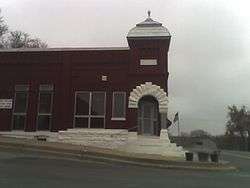 Goff National Bank (2008) | |
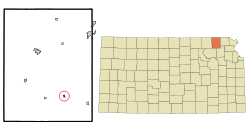 Location within Nemaha County and Kansas | |
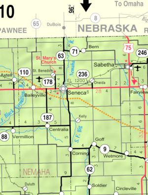 KDOT map of Nemaha County (legend) | |
| Coordinates: 39°39′57″N 95°55′54″W | |
| Country | United States |
| State | Kansas |
| County | Nemaha |
| Founded | 1880 |
| Incorporated | 1887 |
| Named for | Edward Goff |
| Area | |
| • Total | 0.21 sq mi (0.54 km2) |
| • Land | 0.21 sq mi (0.54 km2) |
| • Water | 0 sq mi (0 km2) |
| Elevation | 1,227 ft (374 m) |
| Population | |
| • Total | 126 |
| • Estimate (2016)[3] | 126 |
| • Density | 600/sq mi (230/km2) |
| Time zone | UTC-6 (CST) |
| • Summer (DST) | UTC-5 (CDT) |
| ZIP code | 66428 |
| Area code | 785 |
| FIPS code | 20-26775 [4] |
| GNIS ID | 0473225 [5] |
History
Goff had its start in the year 1880 by the building of the railroad through that territory.[7][8] It was named for Edward H. Goff, an official of the Central Branch Union Pacific Railroad.[9][10]
The name of the post office was officially spelled Goff's from 1880 until 1894.[11]
Geography
Goff is located at 39°39′57″N 95°55′54″W (39.665867, -95.931546).[12] According to the United States Census Bureau, the city has a total area of 0.21 square miles (0.54 km2), all of it land.[1]
Demographics
| Historical population | |||
|---|---|---|---|
| Census | Pop. | %± | |
| 1880 | 29 | — | |
| 1900 | 365 | — | |
| 1910 | 422 | 15.6% | |
| 1920 | 398 | −5.7% | |
| 1930 | 437 | 9.8% | |
| 1940 | 339 | −22.4% | |
| 1950 | 315 | −7.1% | |
| 1960 | 259 | −17.8% | |
| 1970 | 207 | −20.1% | |
| 1980 | 196 | −5.3% | |
| 1990 | 156 | −20.4% | |
| 2000 | 181 | 16.0% | |
| 2010 | 126 | −30.4% | |
| Est. 2016 | 126 | [3] | 0.0% |
| U.S. Decennial Census | |||
2010 census
As of the census[2] of 2010, there were 126 people, 49 households, and 34 families residing in the city. The population density was 600.0 inhabitants per square mile (231.7/km2). There were 62 housing units at an average density of 295.2 per square mile (114.0/km2). The racial makeup of the city was 90.5% White, 1.6% Native American, 0.8% Asian, and 7.1% from two or more races. Hispanic or Latino of any race were 0.8% of the population.
There were 49 households of which 40.8% had children under the age of 18 living with them, 46.9% were married couples living together, 12.2% had a female householder with no husband present, 10.2% had a male householder with no wife present, and 30.6% were non-families. 22.4% of all households were made up of individuals and 6.1% had someone living alone who was 65 years of age or older. The average household size was 2.57 and the average family size was 3.09.
The median age in the city was 33.3 years. 34.1% of residents were under the age of 18; 3.9% were between the ages of 18 and 24; 23.1% were from 25 to 44; 23.9% were from 45 to 64; and 15.1% were 65 years of age or older. The gender makeup of the city was 57.1% male and 42.9% female.
2000 census
As of the census[4] of 2000, there were 181 people, 60 households, and 43 families residing in the city. The population density was 855.4 people per square mile (332.8/km²). There were 72 housing units at an average density of 340.3 per square mile (132.4/km²). The racial makeup of the city was 91.16% White, 1.66% African American, 2.21% Native American, 0.55% Asian, and 4.42% from two or more races. Hispanic or Latino of any race were 2.76% of the population.
There were 60 households out of which 43.3% had children under the age of 18 living with them, 55.0% were married couples living together, 15.0% had a female householder with no husband present, and 26.7% were non-families. 25.0% of all households were made up of individuals and 13.3% had someone living alone who was 65 years of age or older. The average household size was 3.02 and the average family size was 3.66.
In the city, the population was spread out with 38.1% under the age of 18, 9.9% from 18 to 24, 24.9% from 25 to 44, 14.9% from 45 to 64, and 12.2% who were 65 years of age or older. The median age was 26 years. For every 100 females, there were 108.0 males. For every 100 females age 18 and over, there were 96.5 males.
The median income for a household in the city was $35,781, and the median income for a family was $36,667. Males had a median income of $27,500 versus $18,542 for females. The per capita income for the city was $13,028. None of the population or families were below the poverty line.
References
- "US Gazetteer files 2010". United States Census Bureau. Archived from the original on 2012-01-25. Retrieved 2012-07-06.
- "U.S. Census website". United States Census Bureau. Retrieved 2012-07-06.
- "Population and Housing Unit Estimates". Retrieved June 9, 2017.
- "U.S. Census website". United States Census Bureau. Retrieved 2008-01-31.
- "US Board on Geographic Names". United States Geological Survey. 2007-10-25. Retrieved 2008-01-31.
- "2010 City Population and Housing Occupancy Status". U.S. Census Bureau. Retrieved July 2, 2011.
- Blackmar, Frank Wilson (1912). Kansas: A Cyclopedia of State History, Embracing Events, Institutions, Industries, Counties, Cities, Towns, Prominent Persons, Etc. Standard Publishing Company. pp. 761.
- Kansas State Historical Society (1916). Biennial Report of the Board of Directors of the Kansas State Historical Society. Kansas State Printing Plant. pp. 249.
- Rydjord, John (1972). Kansas Place-Names. University of Oklahoma Press, Norman. p. 455. ISBN 0-8061-0994-7.
- Gannett, Henry (1905). The Origin of Certain Place Names in the United States. Govt. Print. Off. pp. 139.
- "Kansas Post Offices, 1828-1961 (archived)". Kansas Historical Society. Archived from the original on October 9, 2013. Retrieved 18 June 2014.
- "US Gazetteer files: 2010, 2000, and 1990". United States Census Bureau. 2011-02-12. Retrieved 2011-04-23.
External links
- City
- Schools
- USD 113, local school district
- Maps
- Goff City Map, KDOT
Municipalities and communities of Nemaha County, Kansas, United States | ||
|---|---|---|
| Cities |  Map of Kansas highlighting Nemaha County | |
| CDP | ||
| Unincorporated communities | ||
| Footnotes | ‡This populated place also has portions in an adjacent county or counties | |