Centralia, Kansas
Centralia is a city in Nemaha County, Kansas, United States. As of the 2010 census, the city's population was 512.[6]
Centralia, Kansas | |
|---|---|
 Location within Nemaha County and Kansas | |
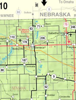 KDOT map of Nemaha County (legend) | |
| Coordinates: 39°43′27″N 96°7′52″W | |
| Country | United States |
| State | Kansas |
| County | Nemaha |
| Founded | 1859 |
| Incorporated | 1882 |
| Area | |
| • Total | 0.47 sq mi (1.22 km2) |
| • Land | 0.47 sq mi (1.22 km2) |
| • Water | 0 sq mi (0 km2) |
| Elevation | 1,273 ft (388 m) |
| Population | |
| • Total | 512 |
| • Estimate (2018)[3] | 517 |
| • Density | 1,100/sq mi (420/km2) |
| Time zone | UTC-6 (CST) |
| • Summer (DST) | UTC-5 (CDT) |
| ZIP code | 66415 |
| Area code | 785 |
| FIPS code | 20-12425 [4] |
| GNIS ID | 0473214 [5] |
| Website | cityofcentraliaks.org |
History
Centralia was founded in 1859, one mile north of the present town. When a railroad was built through the territory in 1867, Centralia was moved to the site.[7] Centralia was incorporated in 1882.[8] One of the early residents of Centralia was Floyd Perry Baker, a Kansas politician and newspaper editor, who moved there with his family from Andrew County, Missouri around 1860.
In 1901, Centralia was the scene of violent conflicts between whites and African Americans. By this time, Centralia had a sundown town policy forbidding blacks from living in the area.[9]
Geography
Centralia is located at 39°43′27″N 96°7′52″W (39.724032, -96.131079).[10] According to the United States Census Bureau, the city has a total area of 0.47 square miles (1.22 km2), all land.[1]
Climate
This climatic region is typified by large seasonal temperature differences, with warm to hot (and often humid) summers and cold (sometimes severely cold) winters. According to the Köppen Climate Classification system, Centralia has a humid continental climate, abbreviated "Dfa" on climate maps.[11]
| Climate data for Centralia, Kansas | |||||||||||||
|---|---|---|---|---|---|---|---|---|---|---|---|---|---|
| Month | Jan | Feb | Mar | Apr | May | Jun | Jul | Aug | Sep | Oct | Nov | Dec | Year |
| Average high °C (°F) | 3 (37) |
6 (43) |
12 (54) |
19 (66) |
24 (75) |
29 (85) |
32 (90) |
32 (89) |
27 (81) |
21 (69) |
12 (53) |
4 (40) |
18 (65) |
| Average low °C (°F) | −9 (16) |
−7 (20) |
−1 (30) |
5 (41) |
11 (51) |
16 (61) |
19 (66) |
18 (64) |
13 (56) |
7 (44) |
−1 (31) |
−7 (20) |
6 (42) |
| Average precipitation mm (inches) | 23 (0.9) |
28 (1.1) |
51 (2) |
74 (2.9) |
110 (4.4) |
130 (5.1) |
100 (4) |
100 (4) |
99 (3.9) |
64 (2.5) |
43 (1.7) |
25 (1) |
850 (33.5) |
| Source: Weatherbase [12] | |||||||||||||
Demographics
| Historical population | |||
|---|---|---|---|
| Census | Pop. | %± | |
| 1880 | 289 | — | |
| 1890 | 534 | 84.8% | |
| 1900 | 655 | 22.7% | |
| 1910 | 665 | 1.5% | |
| 1920 | 619 | −6.9% | |
| 1930 | 682 | 10.2% | |
| 1940 | 607 | −11.0% | |
| 1950 | 574 | −5.4% | |
| 1960 | 527 | −8.2% | |
| 1970 | 511 | −3.0% | |
| 1980 | 486 | −4.9% | |
| 1990 | 452 | −7.0% | |
| 2000 | 534 | 18.1% | |
| 2010 | 512 | −4.1% | |
| Est. 2018 | 517 | [3] | 1.0% |
| U.S. Decennial Census | |||
2010 census
As of the census[2] of 2010, there were 512 people, 201 households, and 123 families residing in the city. The population density was 1,089.4 inhabitants per square mile (420.6/km2). There were 238 housing units at an average density of 506.4 per square mile (195.5/km2). The racial makeup of the city was 94.5% White, 1.2% African American, 0.8% Native American, 0.8% Asian, 0.6% from other races, and 2.1% from two or more races. Hispanic or Latino of any race were 2.5% of the population.
There were 201 households of which 30.8% had children under the age of 18 living with them, 48.8% were married couples living together, 8.5% had a female householder with no husband present, 4.0% had a male householder with no wife present, and 38.8% were non-families. 35.3% of all households were made up of individuals and 19.9% had someone living alone who was 65 years of age or older. The average household size was 2.38 and the average family size was 3.02.
The median age in the city was 40.1 years. 25% of residents were under the age of 18; 5.7% were between the ages of 18 and 24; 25.4% were from 25 to 44; 22.8% were from 45 to 64; and 21.1% were 65 years of age or older. The gender makeup of the city was 50.6% male and 49.4% female.
2000 census
As of the census[4] of 2000, there were 534 people, 216 households, and 127 families residing in the city. The population density was 1,186.0 people per square mile (458.2/km²). There were 235 housing units at an average density of 521.9 per square mile (201.6/km²). The racial makeup of the city was 96.82% White, 0.19% African American, 0.94% Native American, 0.37% Pacific Islander, 0.19% from other races, and 1.50% from two or more races. Hispanic or Latino of any race were 2.81% of the population.
There were 216 households out of which 27.3% had children under the age of 18 living with them, 54.6% were married couples living together, 3.7% had a female householder with no husband present, and 41.2% were non-families. 38.9% of all households were made up of individuals and 28.7% had someone living alone who was 65 years of age or older. The average household size was 2.29 and the average family size was 3.13.
In the city, the population was spread out with 25.7% under the age of 18, 5.1% from 18 to 24, 21.7% from 25 to 44, 17.2% from 45 to 64, and 30.3% who were 65 years of age or older. The median age was 44 years. For every 100 females, there were 87.4 males. For every 100 females age 18 and over, there were 83.8 males.
The median income for a household in the city was $22,240, and the median income for a family was $32,625. Males had a median income of $22,500 versus $16,591 for females. The per capita income for the city was $14,813. About 8.0% of families and 14.5% of the population were below the poverty line, including 19.3% of those under age 18 and 16.6% of those age 65 or over.
Notable people
- Floyd Baker, Kansas politician, lawyer, newspaper editor
- John Riggins, NFL running back
References
- "US Gazetteer files 2010". United States Census Bureau. Archived from the original on 2012-01-25. Retrieved 2012-07-06.
- "U.S. Census website". United States Census Bureau. Retrieved 2012-07-06.
- "Population and Housing Unit Estimates". Retrieved March 17, 2020.
- "U.S. Census website". United States Census Bureau. Retrieved 2008-01-31.
- "US Board on Geographic Names". United States Geological Survey. 2007-10-25. Retrieved 2008-01-31.
- "2010 City Population and Housing Occupancy Status". U.S. Census Bureau. Retrieved July 2, 2011.
- Kansas State Historical Society (1916). Biennial Report of the Board of Directors of the Kansas State Historical Society. Kansas State Printing Plant. pp. 249.
- Blackmar, Frank Wilson (1912). Kansas: A Cyclopedia of State History, Embracing Events, Institutions, Industries, Counties, Cities, Towns, Prominent Persons, Etc. Standard Publishing Company. pp. 307.
- "Negroes Hold a Town". Ottawa County Index. Minneapolis, Kansas. October 3, 1901. p. 1 – via Newspapers.com.
The little town of Centralia, Kan., is in the hands of a mob of negroes. The cause of the trouble grew out of the action of a number of citizens of Centralia, making an attack on the home of a negro by the name of Whitmire and firing several shots through the roof of his house and finally destroying his home and compelling the negroes to flee in the night for safety. No negroes are allowed to live in the vicinity of Centralia. The negroes returned in large numbers and rode up and down the streets firing their guns at random, driving all the whites indoors.
- "US Gazetteer files: 2010, 2000, and 1990". United States Census Bureau. 2011-02-12. Retrieved 2011-04-23.
- Climate Summary for Centralia, Kansas
- "Weatherbase.com". Weatherbase. 2013. Retrieved on October 4, 2013.
External links
| Wikimedia Commons has media related to Centralia, Kansas. |
- City
- Schools
- USD 380, local school district
- Maps
- Centralia City Map, KDOT
Municipalities and communities of Nemaha County, Kansas, United States | ||
|---|---|---|
| Cities | 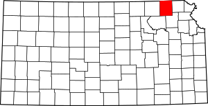 Map of Kansas highlighting Nemaha County | |
| CDP | ||
| Unincorporated communities | ||
| Footnotes | ‡This populated place also has portions in an adjacent county or counties | |